Property Record
7095 3Rd St Se, Turner, OR 97392
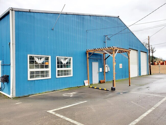

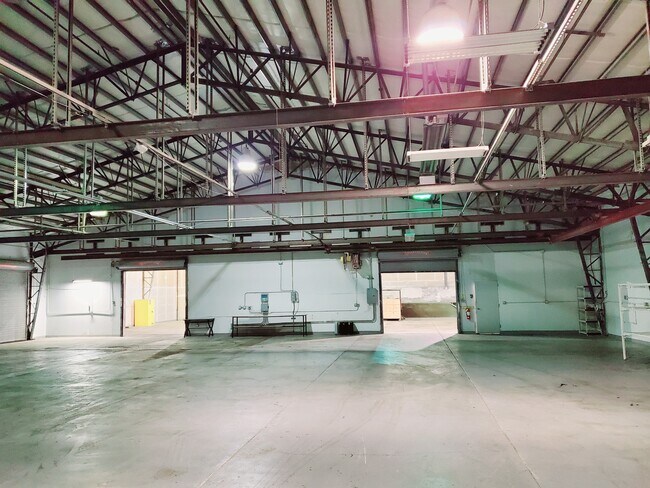

Property Detail
7095 3Rd St Se
530967
ACRES .45
Officebuilding
Marion
C-1
Oregon
AE The base floodplain where base flood elevations are provided. AE Zones are now used on new format FIRMs instead of A1-A30 Zones.
0.45 AC
2024
Marion County
2025
Portland
002701
Salem, OR
11,520 SF
NEARBY LISTINGS FOR SALE OR LEASE
DEMOGRAPHICS near 7095 3Rd St Se
1 mile
3 mile
5 mile
2025 Total Population
3,280
11,780
61,221
2030 Population
3,381
12,016
61,922
Pop Growth 2025-2030
+ 3.08%
+ 2.00%
+ 1.15%
Average Age
43
43
41
2025 Total Households
1,218
3,497
21,716
HH Growth 2025-2030
+ 3.20%
+ 2.23%
+ 1.25%
Median Household Inc
$104,334
$100,240
$88,096
Avg Household Size
2.70
2.60
2.60
2025 Avg HH Vehicles
2.00
2.00
2.00
Median Home Value
$661,840
$666,478
$461,440
Median Year Built
1990
1992
1990
Nearby Places
Map Layers
Map Styles
 Street
 Aerial
Layers
 Traffic
 Biking
Places
Listings with unknown addresses are not visible on the map
- Restaurants
- Banks
- Shops
- Fitness
- Groceries
PUBLIC TRANSPORTATION
COMMUTER RAIL
Drive
Walk
Distance
14 min
7.6 mi
SALE & LEASE HISTORY
LISTING DATE
SALE/LEASE

Mar 13, 2018
For Lease
Jun 17, 2021
For Sale
Nearby Properties
Address
Land Use
TOTAL SIZE
Lot Size
Zoning
Address
Land Use
TOTAL SIZE
Lot Size
Zoning
412,248 SF
27.80 AC
Address
Land Use
TOTAL SIZE
Lot Size
Zoning
193,237 SF
9.98 AC
IG
Address
Land Use
TOTAL SIZE
Lot Size
Zoning
310,408 SF
203.73 AC
PH; PE
Address
Land Use
TOTAL SIZE
Lot Size
Zoning
Address
Land Use
TOTAL SIZE
Lot Size
Zoning
118,239 SF
10.69 AC
IG
Address
Land Use
TOTAL SIZE
Lot Size
Zoning
174,632 SF
4.58 AC
CO
Address
Land Use
TOTAL SIZE
Lot Size
Zoning
51,473 SF
5.01 AC
CO
Address
Land Use
TOTAL SIZE
Lot Size
Zoning
127,442 SF
8.69 AC
R-11
Address
Land Use
TOTAL SIZE
Lot Size
Zoning
161,616 SF
6.74 AC
EC
Address
Land Use
TOTAL SIZE
Lot Size
Zoning
59,705 SF
10.08 AC
UT-10
Address
Land Use
TOTAL SIZE
Lot Size
Zoning
48,762 SF
8.78 AC
P-1; R-11
Address
Land Use
TOTAL SIZE
Lot Size
Zoning
74,519 SF
36.38 AC
R-2
Address
Land Use
TOTAL SIZE
Lot Size
Zoning
Address
Land Use
TOTAL SIZE
Lot Size
Zoning
Address
Land Use
TOTAL SIZE
Lot Size
Zoning
3,975 SF
10 AC
Address
Land Use
TOTAL SIZE
Lot Size
Zoning
30,320 SF
3.06 AC
R-11
Address
Land Use
TOTAL SIZE
Lot Size
Zoning
Address
Land Use
TOTAL SIZE
Lot Size
Zoning
1,234 SF
0.69 AC
CO; RA
Address
Land Use
TOTAL SIZE
Lot Size
Zoning
35.04 AC
EC
Address
Land Use
TOTAL SIZE
Lot Size
Zoning
58,560 SF
3.87 AC
IG
Address
Land Use
TOTAL SIZE
Lot Size
Zoning
45,740 SF
4.74 AC
IG-LU
Address
Land Use
TOTAL SIZE
Lot Size
Zoning
36,213 SF
C
Address
Land Use
TOTAL SIZE
Lot Size
Zoning
19,623 SF
1.91 AC
CO
Address
Land Use
TOTAL SIZE
Lot Size
Zoning
26.17 AC
EC
Address
Land Use
TOTAL SIZE
Lot Size
Zoning
39,316 SF
5.08 AC
IG
Address
Land Use
TOTAL SIZE
Lot Size
Zoning
Address
Land Use
TOTAL SIZE
Lot Size
Zoning
12,930 SF
1.79 AC
P-1
Address
Land Use
TOTAL SIZE
Lot Size
Zoning
36,720 SF
5 AC
M-1
Address
Land Use
TOTAL SIZE
Lot Size
Zoning
38,401 SF
19.74 AC
R-2
The World's #1 Commercial Real Estate Marketplace
Connect with us
© 2026 CoStar Group
The information above has been obtained from sources believed reliable. While we do not doubt its accuracy we have not verified it and make no guarantee, warranty or representation about it. It is your responsibility to independently confirm its accuracy and completeness. Any projections, opinions, assumptions, or estimates used are for example only and do not represent the current or future performance of the property. The value of this transaction to you depends on tax and other factors which should be evaluated by your tax, financial, and legal advisors. You and your advisors should conduct a careful, independent investigation of the property to determine to your satisfaction the suitability of the property for your needs.