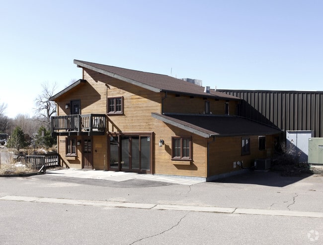
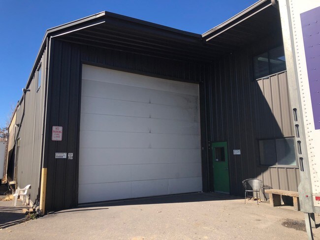
Property Record
7128 Reynolds Dr, Sedalia, CO 80135


Save to a Folder
{{folder.Name}}
{{folder.ListingIds.length}} Properties
{{folder.ListingIds.length}} Property
Create a New Folder
Property Detail
7128 Reynolds Dr
2353-030-02-018
LOT 18 REYNOLDS INDUSTRIAL PARK 1.898 AM/L
Multipleuses
Douglas
GI
Colorado
B and X Area of moderate flood hazard, usually the area between the limits of the 100-year and 500-year floods.
18
2024
1.90 AC
2026
Southwest C-470
014135
Denver
30,357 SF
Denver-Aurora-Centennial, CO
NEARBY LISTINGS FOR SALE OR LEASE
DEMOGRAPHICS near 7128 Reynolds Dr
1 mile
3 mile
5 mile
2025 Total Population
74
1,792
50,127
2030 Population
84
2,055
53,822
Pop Growth 2025-2030
+ 13.51%
+ 14.68%
+ 7.37%
Average Age
45
46
40
2025 Total Households
27
675
16,581
HH Growth 2025-2030
+ 14.81%
+ 15.41%
+ 7.82%
Median Household Inc
$175,000
$166,087
$185,224
Avg Household Size
2.70
2.60
3.00
2025 Avg HH Vehicles
3.00
3.00
2.00
Median Home Value
$1,065,625
$1,032,143
$851,493
Median Year Built
2010
2010
2003
Nearby Places
Map Layers
Map Styles
 Street
 Aerial
Layers
 Traffic
 Biking
Places
Listings with unknown addresses are not visible on the map
- Restaurants
- Banks
- Shops
- Fitness
- Groceries
PUBLIC TRANSPORTATION
AIRPORT
Denver International
Drive
Walk
Distance
Denver International
59 min
49.3 mi
SALE & LEASE HISTORY
LISTING DATE
SALE/LEASE

Nov 06, 2018
For Lease
Nearby Properties
Address
Land Use
TOTAL SIZE
Lot Size
Zoning
Address
Land Use
TOTAL SIZE
Lot Size
Zoning
41,888 SF
154.73 AC
PDNU
Address
Land Use
TOTAL SIZE
Lot Size
Zoning
26.07 AC
Address
Land Use
TOTAL SIZE
Lot Size
Zoning
29,950 SF
4.53 AC
GI
Address
Land Use
TOTAL SIZE
Lot Size
Zoning
2,338 SF
320 AC
A1
Address
Land Use
TOTAL SIZE
Lot Size
Zoning
5,000 SF
36.99 AC
PDU
Address
Land Use
TOTAL SIZE
Lot Size
Zoning
8,770 SF
40.75 AC
Address
Land Use
TOTAL SIZE
Lot Size
Zoning
22,595 SF
2.21 AC
GI
Address
Land Use
TOTAL SIZE
Lot Size
Zoning
48.11 AC
Address
Land Use
TOTAL SIZE
Lot Size
Zoning
31,428 SF
2.62 AC
GI
Address
Land Use
TOTAL SIZE
Lot Size
Zoning
20,732 SF
2.97 AC
GI
Address
Land Use
TOTAL SIZE
Lot Size
Zoning
20,000 SF
2.79 AC
GI
Address
Land Use
TOTAL SIZE
Lot Size
Zoning
29,949 SF
79.43 AC
GI
Address
Land Use
TOTAL SIZE
Lot Size
Zoning
11,300 SF
222.72 AC
Address
Land Use
TOTAL SIZE
Lot Size
Zoning
14,380 SF
3.11 AC
Address
Land Use
TOTAL SIZE
Lot Size
Zoning
12,000 SF
3.98 AC
GI
Address
Land Use
TOTAL SIZE
Lot Size
Zoning
171 SF
11.64 AC
Address
Land Use
TOTAL SIZE
Lot Size
Zoning
12,000 SF
1.52 AC
GI
Address
Land Use
TOTAL SIZE
Lot Size
Zoning
1 SF
35.31 AC
PDU
Address
Land Use
TOTAL SIZE
Lot Size
Zoning
8,820 SF
2.21 AC
GI
Address
Land Use
TOTAL SIZE
Lot Size
Zoning
16,830 SF
6.35 AC
GI
Address
Land Use
TOTAL SIZE
Lot Size
Zoning
8,611 SF
1.62 AC
GI
Address
Land Use
TOTAL SIZE
Lot Size
Zoning
8,480 SF
2.67 AC
GI
Address
Land Use
TOTAL SIZE
Lot Size
Zoning
9,869 SF
1.34 AC
GI
Address
Land Use
TOTAL SIZE
Lot Size
Zoning
4,250 SF
19.10 AC
GI
Address
Land Use
TOTAL SIZE
Lot Size
Zoning
8,400 SF
2.15 AC
GI
Address
Land Use
TOTAL SIZE
Lot Size
Zoning
23,014 SF
4.51 AC
RR
Address
Land Use
TOTAL SIZE
Lot Size
Zoning
6,768 SF
5.36 AC
GI
Address
Land Use
TOTAL SIZE
Lot Size
Zoning
12,300 SF
2.97 AC
GI
The World's #1 Commercial Real Estate Marketplace
Connect with us
© 2026 CoStar Group
The information above has been obtained from sources believed reliable. While we do not doubt its accuracy we have not verified it and make no guarantee, warranty or representation about it. It is your responsibility to independently confirm its accuracy and completeness. Any projections, opinions, assumptions, or estimates used are for example only and do not represent the current or future performance of the property. The value of this transaction to you depends on tax and other factors which should be evaluated by your tax, financial, and legal advisors. You and your advisors should conduct a careful, independent investigation of the property to determine to your satisfaction the suitability of the property for your needs.