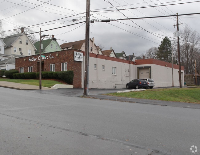
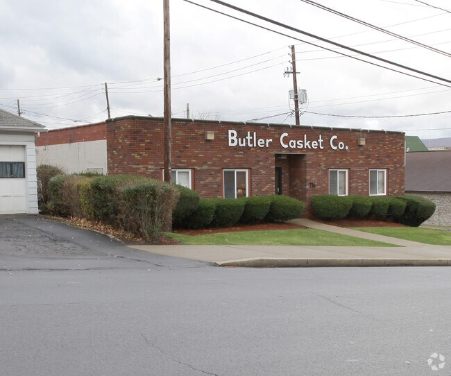
Property Record
716 Ash St, Scranton, PA 18510
NEARBY LISTINGS FOR SALE OR LEASE
Property Detail
716 Ash St
Scranton--Wilkes-Barre--Hazelton, PA
Kramer & Goodman
14662020001
70X110 BLDG & LAND W-09 B-0170 L-001B P-02800
Taxexempt
Lackawanna
X
Pennsylvania
42069C0217D
1b
2025
0.18 AC
2025
I-81 Corridor
100600
Philadelphia
DEMOGRAPHICS near 716 Ash St
1 Mile
3 Mile
5 Mile
2024 Total Population
24,613
91,482
117,854
2029 Population
24,513
90,736
116,798
Pop Growth 2024-2029
(0.41%)
(0.82%)
(0.90%)
Average Age
39
40
41
2024 Total Households
8,932
36,737
48,227
HH Growth 2024-2029
(0.30%)
(0.86%)
(0.93%)
Median Household Inc
$43,169
$50,785
$54,592
Avg Household Size
2.10
2.20
2.20
2024 Avg HH Vehicles
1.00
1.00
2.00
Median Home Value
$153,341
$139,464
$149,320
Median Year Built
1947
1947
1948
Nearby Places
Map Layers
Map Styles
 Street
 Aerial
- Restaurants
- Banks
- Shops
- Fitness
- Groceries
PUBLIC TRANSPORTATION
AIRPORT
Wilkes-Barre/Scranton International
DRIVE
WALK
Distance
Wilkes-Barre/Scranton International
17 min
9.7 mi
Nearby Properties
Address
Land Use
TOTAL SIZE
Lot Size
Zoning
Address
Land Use
TOTAL SIZE
Lot Size
Zoning
2.62 AC
Address
Land Use
TOTAL SIZE
Lot Size
Zoning
Address
Land Use
TOTAL SIZE
Lot Size
Zoning
Address
Land Use
TOTAL SIZE
Lot Size
Zoning
43.66 AC
Address
Land Use
TOTAL SIZE
Lot Size
Zoning
Address
Land Use
TOTAL SIZE
Lot Size
Zoning
2.40 AC
Address
Land Use
TOTAL SIZE
Lot Size
Zoning
2.30 AC
Address
Land Use
TOTAL SIZE
Lot Size
Zoning
4.20 AC
Address
Land Use
TOTAL SIZE
Lot Size
Zoning
15.50 AC
Address
Land Use
TOTAL SIZE
Lot Size
Zoning
3.86 AC
Address
Land Use
TOTAL SIZE
Lot Size
Zoning
0.99 AC
Address
Land Use
TOTAL SIZE
Lot Size
Zoning
12.88 AC
Address
Land Use
TOTAL SIZE
Lot Size
Zoning
7.81 AC
Address
Land Use
TOTAL SIZE
Lot Size
Zoning
43.52 AC
Address
Land Use
TOTAL SIZE
Lot Size
Zoning
Address
Land Use
TOTAL SIZE
Lot Size
Zoning
4.85 AC
Address
Land Use
TOTAL SIZE
Lot Size
Zoning
Address
Land Use
TOTAL SIZE
Lot Size
Zoning
Address
Land Use
TOTAL SIZE
Lot Size
Zoning
25.62 AC
Address
Land Use
TOTAL SIZE
Lot Size
Zoning
2.65 AC
Address
Land Use
TOTAL SIZE
Lot Size
Zoning
0.27 AC
Address
Land Use
TOTAL SIZE
Lot Size
Zoning
97.16 AC
Address
Land Use
TOTAL SIZE
Lot Size
Zoning
Address
Land Use
TOTAL SIZE
Lot Size
Zoning
5.35 AC
Address
Land Use
TOTAL SIZE
Lot Size
Zoning
Address
Land Use
TOTAL SIZE
Lot Size
Zoning
3.86 AC
Address
Land Use
TOTAL SIZE
Lot Size
Zoning
Address
Land Use
TOTAL SIZE
Lot Size
Zoning
Address
Land Use
TOTAL SIZE
Lot Size
Zoning
3.11 AC
Address
Land Use
TOTAL SIZE
Lot Size
Zoning
9.55 AC
The World's #1 Commercial Real Estate Marketplace
Connect with us
© 2025 CoStar Group
The information above has been obtained from sources believed reliable. While we do not doubt its accuracy we have not verified it and make no guarantee, warranty or representation about it. It is your responsibility to independently confirm its accuracy and completeness. Any projections, opinions, assumptions, or estimates used are for example only and do not represent the current or future performance of the property. The value of this transaction to you depends on tax and other factors which should be evaluated by your tax, financial, and legal advisors. You and your advisors should conduct a careful, independent investigation of the property to determine to your satisfaction the suitability of the property for your needs.