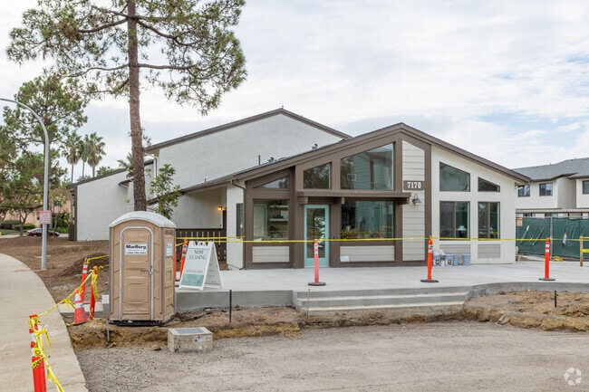
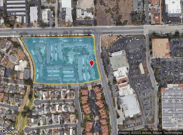
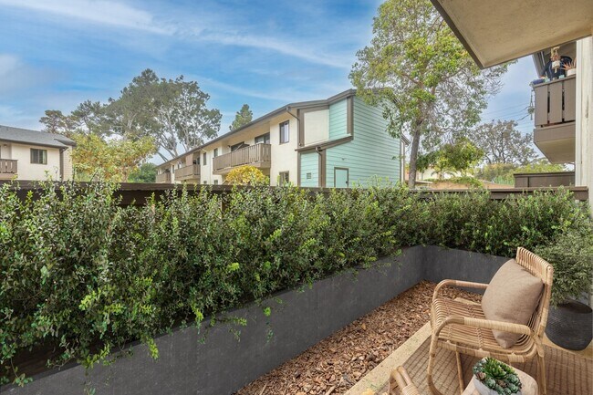
Property Record
7170 Davenport Rd, Goleta, CA 93117
NEARBY LISTINGS FOR SALE OR LEASE
Property Detail
7170 Davenport Rd
Santa Maria-Santa Barbara, CA
Santa Barbara
073-230-050
Santa Barbara
Apartment
California
AE
1
06083C1342H
8.22 AC
2024
West Santa Barbara
2025
Santa Barbara/Sta Maria/Goleta
002935
DEMOGRAPHICS near 7170 Davenport Rd
1 mile
3 mile
5 mile
2024 Total Population
15,539
43,520
65,206
2029 Population
15,438
43,166
64,612
Pop Growth 2024-2029
(0.65%)
(0.81%)
(0.91%)
Average Age
36
33
36
2024 Total Households
5,375
14,097
21,965
HH Growth 2024-2029
(0.63%)
(0.91%)
(0.98%)
Median Household Inc
$105,384
$76,032
$92,977
Avg Household Size
2.70
2.70
2.70
2024 Avg HH Vehicles
2.00
2.00
2.00
Median Home Value
$793,712
$823,047
$887,036
Median Year Built
1977
1975
1972
Nearby Places
Map Layers
Map Styles
 Street
 Aerial
Transit
 Traffic
 Biking
Places
Listings with unknown addresses are not visible on the map
- Restaurants
- Banks
- Shops
- Fitness
- Groceries
PUBLIC TRANSPORTATION
COMMUTER RAIL
Drive
Walk
Distance
6 min
2.7 mi
AIRPORT
Santa Barbara Municipal
Drive
Walk
Distance
Santa Barbara Municipal
18 min
4.1 mi
Freight Ports
The Port of Hueneme
Drive
Walk
Distance
The Port of Hueneme
68 min
51.3 mi
Nearby Properties
Address
Land Use
TOTAL SIZE
Lot Size
Zoning
Address
Land Use
TOTAL SIZE
Lot Size
Zoning
30.03 AC
Address
Land Use
TOTAL SIZE
Lot Size
Zoning
2.50 AC
SRH20
Address
Land Use
TOTAL SIZE
Lot Size
Zoning
1.90 AC
Address
Land Use
TOTAL SIZE
Lot Size
Zoning
13.08 AC
Address
Land Use
TOTAL SIZE
Lot Size
Zoning
39.17 AC
Address
Land Use
TOTAL SIZE
Lot Size
Zoning
8.82 AC
Address
Land Use
TOTAL SIZE
Lot Size
Zoning
4.25 AC
Address
Land Use
TOTAL SIZE
Lot Size
Zoning
2.42 AC
SRH20
Address
Land Use
TOTAL SIZE
Lot Size
Zoning
2.18 AC
Address
Land Use
TOTAL SIZE
Lot Size
Zoning
102,570 SF
14.03 AC
Address
Land Use
TOTAL SIZE
Lot Size
Zoning
3.05 AC
Address
Land Use
TOTAL SIZE
Lot Size
Zoning
37,584 SF
2 AC
SRH20
Address
Land Use
TOTAL SIZE
Lot Size
Zoning
3.81 AC
Address
Land Use
TOTAL SIZE
Lot Size
Zoning
85,052 SF
2.97 AC
SRH20
Address
Land Use
TOTAL SIZE
Lot Size
Zoning
7.18 AC
Address
Land Use
TOTAL SIZE
Lot Size
Zoning
7.99 AC
Address
Land Use
TOTAL SIZE
Lot Size
Zoning
0.87 AC
SRH20
Address
Land Use
TOTAL SIZE
Lot Size
Zoning
129,096 SF
11.56 AC
Address
Land Use
TOTAL SIZE
Lot Size
Zoning
13.74 AC
Address
Land Use
TOTAL SIZE
Lot Size
Zoning
6.90 AC
Address
Land Use
TOTAL SIZE
Lot Size
Zoning
0.38 AC
C2
Address
Land Use
TOTAL SIZE
Lot Size
Zoning
10.19 AC
Address
Land Use
TOTAL SIZE
Lot Size
Zoning
5.34 AC
Address
Land Use
TOTAL SIZE
Lot Size
Zoning
18.65 AC
Address
Land Use
TOTAL SIZE
Lot Size
Zoning
8.33 AC
Address
Land Use
TOTAL SIZE
Lot Size
Zoning
6.66 AC
Address
Land Use
TOTAL SIZE
Lot Size
Zoning
9.85 AC
Address
Land Use
TOTAL SIZE
Lot Size
Zoning
285,000 SF
4.91 AC
Address
Land Use
TOTAL SIZE
Lot Size
Zoning
1.60 AC
SRH20
Address
Land Use
TOTAL SIZE
Lot Size
Zoning
1.97 AC
SRH20
The World's #1 Commercial Real Estate Marketplace
Connect with us
© 2026 CoStar Group
The information above has been obtained from sources believed reliable. While we do not doubt its accuracy we have not verified it and make no guarantee, warranty or representation about it. It is your responsibility to independently confirm its accuracy and completeness. Any projections, opinions, assumptions, or estimates used are for example only and do not represent the current or future performance of the property. The value of this transaction to you depends on tax and other factors which should be evaluated by your tax, financial, and legal advisors. You and your advisors should conduct a careful, independent investigation of the property to determine to your satisfaction the suitability of the property for your needs.