Property Record
719 Cedar St, Newington, CT 06111
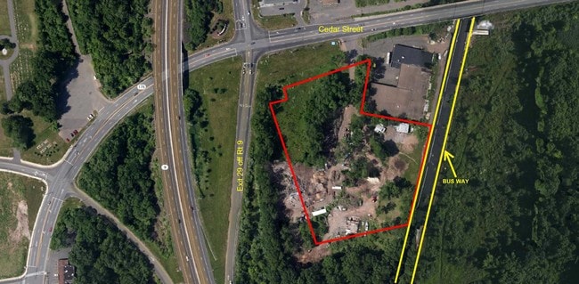

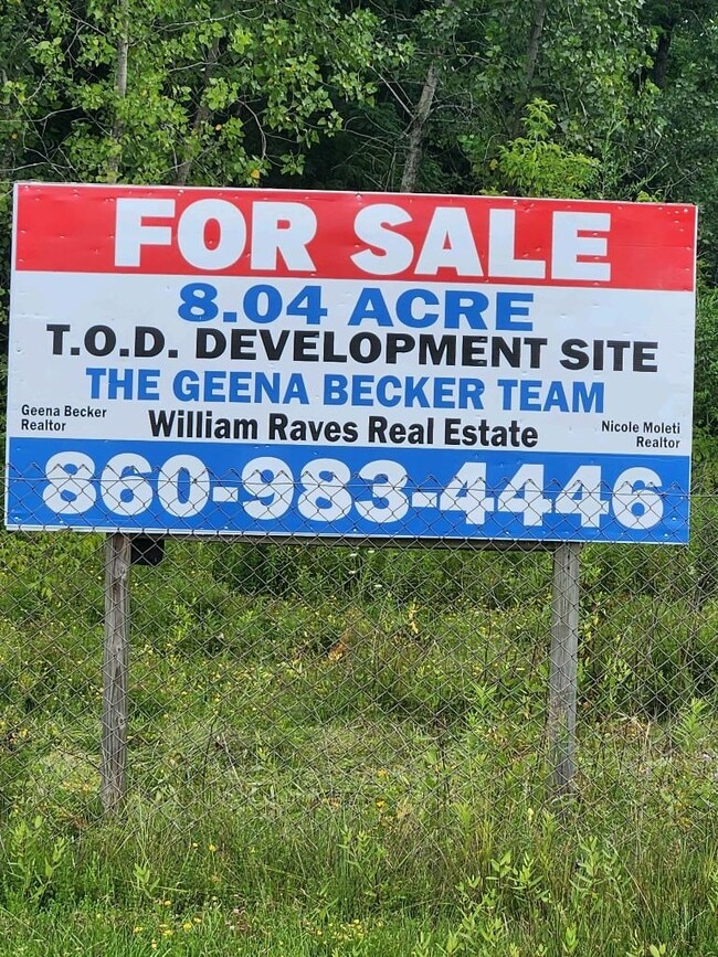
This Property Is For Sale
Property Detail
719 Cedar St
NEWI-000013-000003
HARTFORD
Commercialacreage
Connecticut
I
8.04 AC
B and X Area of moderate flood hazard, usually the area between the limits of the 100-year and 500-year floods.
Newington
2024
Hartford
2025
Hartford-West Hartford-East Hartford, CT
494300
NEARBY LISTINGS FOR SALE OR LEASE
DEMOGRAPHICS near 719 Cedar St
1 mile
3 mile
5 mile
2025 Total Population
8,115
99,919
211,451
2030 Population
8,241
100,966
213,914
Pop Growth 2025-2030
+ 1.55%
+ 1.05%
+ 1.16%
Average Age
36
40
41
2025 Total Households
2,577
40,082
84,407
HH Growth 2025-2030
+ 1.86%
+ 1.09%
+ 1.21%
Median Household Inc
$74,999
$69,791
$84,211
Avg Household Size
2.30
2.40
2.40
2025 Avg HH Vehicles
2.00
2.00
2.00
Median Home Value
$245,274
$267,411
$300,301
Median Year Built
1957
1958
1957
Nearby Places
Map Layers
Map Styles
 Street
 Aerial
Layers
 Traffic
 Biking
Places
Listings with unknown addresses are not visible on the map
- Restaurants
- Banks
- Shops
- Fitness
- Groceries
PUBLIC TRANSPORTATION
COMMUTER RAIL
Berlin (Hartford Line - CONN DOT)
Drive
Walk
Distance
Berlin (Hartford Line - CONN DOT)
9 min
5.2 mi
Berlin Amtrak (Amtrak Hartford Line - Amtrak, Northeast Regional - Amtrak, Valley Flyer - Amtrak)
Drive
Walk
Distance
Berlin Amtrak (Amtrak Hartford Line - Amtrak, Northeast Regional - Amtrak, Valley Flyer - Amtrak)
9 min
5.2 mi
AIRPORT
Bradley International
Drive
Walk
Distance
Bradley International
45 min
25.8 mi
Freight Ports
Port of New Haven
Drive
Walk
Distance
Port of New Haven
44 min
33.2 mi
Nearby Properties
Address
Land Use
TOTAL SIZE
Lot Size
Zoning
Address
Land Use
TOTAL SIZE
Lot Size
Zoning
146,740 SF
18.23 AC
TPC
Address
Land Use
TOTAL SIZE
Lot Size
Zoning
284,432 SF
32.12 AC
PL
Address
Land Use
TOTAL SIZE
Lot Size
Zoning
23.64 AC
S3
Address
Land Use
TOTAL SIZE
Lot Size
Zoning
261,072 SF
44.47 AC
PL
Address
Land Use
TOTAL SIZE
Lot Size
Zoning
54.95 AC
PDR
Address
Land Use
TOTAL SIZE
Lot Size
Zoning
20.61 AC
R-10,S
Address
Land Use
TOTAL SIZE
Lot Size
Zoning
131.09 AC
OP
Address
Land Use
TOTAL SIZE
Lot Size
Zoning
19.60 AC
S2
Address
Land Use
TOTAL SIZE
Lot Size
Zoning
2.07 AC
CBD
Address
Land Use
TOTAL SIZE
Lot Size
Zoning
23.62 AC
A3
Address
Land Use
TOTAL SIZE
Lot Size
Zoning
117,139 SF
6.77 AC
T
Address
Land Use
TOTAL SIZE
Lot Size
Zoning
90,625 SF
0.97 AC
CBD
Address
Land Use
TOTAL SIZE
Lot Size
Zoning
0.01 AC
PR
Address
Land Use
TOTAL SIZE
Lot Size
Zoning
96,238 SF
6.75 AC
T
Address
Land Use
TOTAL SIZE
Lot Size
Zoning
14.68 AC
SIF
Address
Land Use
TOTAL SIZE
Lot Size
Zoning
2.46 AC
CBD
Address
Land Use
TOTAL SIZE
Lot Size
Zoning
13.34 AC
PD
Address
Land Use
TOTAL SIZE
Lot Size
Zoning
78,109 SF
8.22 AC
T
Address
Land Use
TOTAL SIZE
Lot Size
Zoning
112,304 SF
10.39 AC
S3
Address
Land Use
TOTAL SIZE
Lot Size
Zoning
16.94 AC
C1
Address
Land Use
TOTAL SIZE
Lot Size
Zoning
215,215 SF
42 AC
R-10,R
Address
Land Use
TOTAL SIZE
Lot Size
Zoning
171,729 SF
80.59 AC
R-12/
Address
Land Use
TOTAL SIZE
Lot Size
Zoning
14,364 SF
2.72 AC
S3
Address
Land Use
TOTAL SIZE
Lot Size
Zoning
13.13 AC
SDD/BG
Address
Land Use
TOTAL SIZE
Lot Size
Zoning
111,532 SF
12.50 AC
R-12
Address
Land Use
TOTAL SIZE
Lot Size
Zoning
68 AC
R-20
Address
Land Use
TOTAL SIZE
Lot Size
Zoning
18.40 AC
PD
Address
Land Use
TOTAL SIZE
Lot Size
Zoning
78,132 SF
11.76 AC
S2
Address
Land Use
TOTAL SIZE
Lot Size
Zoning
5.20 AC
PD
Address
Land Use
TOTAL SIZE
Lot Size
Zoning
83,464 SF
13.96 AC
T
The World's #1 Commercial Real Estate Marketplace
Connect with us
© 2026 CoStar Group
The information above has been obtained from sources believed reliable. While we do not doubt its accuracy we have not verified it and make no guarantee, warranty or representation about it. It is your responsibility to independently confirm its accuracy and completeness. Any projections, opinions, assumptions, or estimates used are for example only and do not represent the current or future performance of the property. The value of this transaction to you depends on tax and other factors which should be evaluated by your tax, financial, and legal advisors. You and your advisors should conduct a careful, independent investigation of the property to determine to your satisfaction the suitability of the property for your needs.