Property Record
720 E Shady Ln, Neenah, WI 54956

Save to a Folder
{{folder.Name}}
{{folder.ListingIds.length}} Properties
{{folder.ListingIds.length}} Property
Create a New Folder
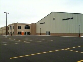
Property Detail
720 E Shady Ln
Oshkosh-Neenah, WI
PT SW SE & PT SE SW DESC AS LOT 2 OF CSM-4474 5.99 A.
121-0140-02
WINNEBAGO
Taxexempt
Wisconsin
B3
2
B and X Area of moderate flood hazard, usually the area between the limits of the 100-year and 500-year floods.
5.99 AC
0
Appleton/Oshkosh
2025
Other Market Areas
002402
NEARBY LISTINGS FOR SALE OR LEASE
DEMOGRAPHICS near 720 E Shady Ln
1 mile
3 mile
5 mile
2025 Total Population
4,338
42,972
128,263
2030 Population
4,356
43,534
130,376
Pop Growth 2025-2030
+ 0.41%
+ 1.31%
+ 1.65%
Average Age
40
41
40
2025 Total Households
1,831
18,771
54,275
HH Growth 2025-2030
+ 0.33%
+ 1.24%
+ 1.72%
Median Household Inc
$80,613
$68,254
$73,310
Avg Household Size
2.30
2.20
2.30
2025 Avg HH Vehicles
2.00
2.00
2.00
Median Home Value
$254,104
$219,744
$224,519
Median Year Built
1988
1976
1973
Nearby Places
Map Layers
Map Styles
 Street
 Aerial
Layers
 Traffic
 Biking
Places
Listings with unknown addresses are not visible on the map
- Restaurants
- Banks
- Shops
- Fitness
- Groceries
PUBLIC TRANSPORTATION
AIRPORT
Appleton International
Drive
Walk
Distance
Appleton International
10 min
4.1 mi
Green Bay/Austin Straubel International
Drive
Walk
Distance
Green Bay/Austin Straubel International
43 min
32.9 mi
Nearby Properties
Address
Land Use
TOTAL SIZE
Lot Size
Zoning
Address
Land Use
TOTAL SIZE
Lot Size
Zoning
645,392 SF
25.87 AC
Address
Land Use
TOTAL SIZE
Lot Size
Zoning
68.77 AC
Address
Land Use
TOTAL SIZE
Lot Size
Zoning
156.36 AC
M1
Address
Land Use
TOTAL SIZE
Lot Size
Zoning
120.73 AC
M2
Address
Land Use
TOTAL SIZE
Lot Size
Zoning
8.61 AC
R5
Address
Land Use
TOTAL SIZE
Lot Size
Zoning
11.99 AC
Address
Land Use
TOTAL SIZE
Lot Size
Zoning
46,300 SF
23.21 AC
M2
Address
Land Use
TOTAL SIZE
Lot Size
Zoning
11.22 AC
Address
Land Use
TOTAL SIZE
Lot Size
Zoning
267,069 SF
26.76 AC
Address
Land Use
TOTAL SIZE
Lot Size
Zoning
9.40 AC
Address
Land Use
TOTAL SIZE
Lot Size
Zoning
Address
Land Use
TOTAL SIZE
Lot Size
Zoning
194,738 SF
19.73 AC
Address
Land Use
TOTAL SIZE
Lot Size
Zoning
148,743 SF
17.58 AC
Address
Land Use
TOTAL SIZE
Lot Size
Zoning
249,444 SF
18.81 AC
Address
Land Use
TOTAL SIZE
Lot Size
Zoning
11,340 SF
0.92 AC
C2
Address
Land Use
TOTAL SIZE
Lot Size
Zoning
178,750 SF
C2
Address
Land Use
TOTAL SIZE
Lot Size
Zoning
81,252 SF
8.32 AC
Address
Land Use
TOTAL SIZE
Lot Size
Zoning
103,427 SF
PDD
Address
Land Use
TOTAL SIZE
Lot Size
Zoning
89,042 SF
2.83 AC
C2
Address
Land Use
TOTAL SIZE
Lot Size
Zoning
10.42 AC
Address
Land Use
TOTAL SIZE
Lot Size
Zoning
89,576 SF
1.03 AC
C2
Address
Land Use
TOTAL SIZE
Lot Size
Zoning
105,852 SF
0.39 AC
PDD
Address
Land Use
TOTAL SIZE
Lot Size
Zoning
15.73 AC
B5
Address
Land Use
TOTAL SIZE
Lot Size
Zoning
166,336 SF
8.94 AC
Address
Land Use
TOTAL SIZE
Lot Size
Zoning
86,455 SF
PDD
Address
Land Use
TOTAL SIZE
Lot Size
Zoning
23,134 SF
0.08 AC
Address
Land Use
TOTAL SIZE
Lot Size
Zoning
4.33 AC
Address
Land Use
TOTAL SIZE
Lot Size
Zoning
189,722 SF
21.52 AC
Address
Land Use
TOTAL SIZE
Lot Size
Zoning
20.92 AC
R5
Address
Land Use
TOTAL SIZE
Lot Size
Zoning
17.55 AC
A2
The World's #1 Commercial Real Estate Marketplace
Connect with us
© 2026 CoStar Group
The information above has been obtained from sources believed reliable. While we do not doubt its accuracy we have not verified it and make no guarantee, warranty or representation about it. It is your responsibility to independently confirm its accuracy and completeness. Any projections, opinions, assumptions, or estimates used are for example only and do not represent the current or future performance of the property. The value of this transaction to you depends on tax and other factors which should be evaluated by your tax, financial, and legal advisors. You and your advisors should conduct a careful, independent investigation of the property to determine to your satisfaction the suitability of the property for your needs.