Property Record
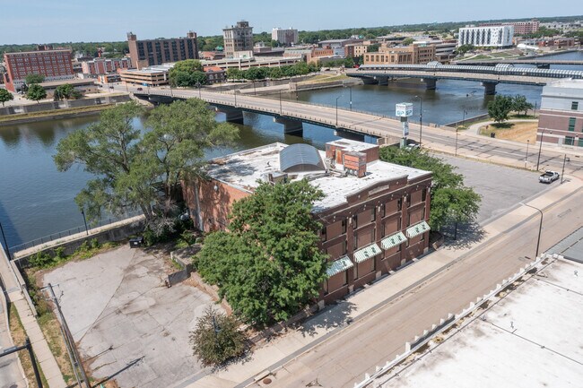
722 E Water St, Waterloo, IA 50703


Property Detail
722 E Water St
Waterloo-Cedar Falls, IA
ORIGINAL PLAT WATERLOO EAST PART NW SEC 25 T 89 R 13 ALSO REFERRED TO AS FRAC BLK OPPOSITE BLK 2 OF ORIG PLAT EAST LYING
8913-25-109-014
Black Hawk
Officebuilding
Iowa
2025
0.83 AC
2025
Downtown Waterloo
000100
Other Market Areas
24,457 SF
NEARBY LISTINGS FOR SALE OR LEASE
-
-
-
-
-
-
-
No Photo
-
View all Waterloo listings for sale on LoopNet.com
DEMOGRAPHICS near 722 E Water St
1 mile
3 mile
5 mile
2025 Total Population
10,991
57,209
80,148
2030 Population
11,360
58,205
81,433
Pop Growth 2025-2030
+ 3.36%
+ 1.74%
+ 1.60%
Average Age
37
39
40
2025 Total Households
4,655
24,488
34,689
HH Growth 2025-2030
+ 3.74%
+ 1.80%
+ 1.66%
Median Household Inc
$38,612
$50,958
$54,923
Avg Household Size
2.20
2.20
2.20
2025 Avg HH Vehicles
1.00
2.00
2.00
Median Home Value
$94,667
$144,927
$162,328
Median Year Built
1949
1957
1962
Nearby Places
Map Layers
Map Styles
 Street
 Aerial
Layers
 Traffic
 Biking
Places
Listings with unknown addresses are not visible on the map
- Restaurants
- Banks
- Shops
- Fitness
- Groceries
SALE & LEASE HISTORY
LISTING DATE
SALE/LEASE

Sep 25, 2016
For Lease
Sep 23, 2016
For Sale
Oct 28, 2016
For Lease
Mar 07, 2017
For Lease
Mar 07, 2017
For Sale
Jul 19, 2021
For Sale
Nearby Properties
Address
Land Use
TOTAL SIZE
Lot Size
Zoning
Address
Land Use
TOTAL SIZE
Lot Size
Zoning
596,653 SF
31.45 AC
Address
Land Use
TOTAL SIZE
Lot Size
Zoning
528,634 SF
13.33 AC
Address
Land Use
TOTAL SIZE
Lot Size
Zoning
108,671 SF
3.72 AC
Address
Land Use
TOTAL SIZE
Lot Size
Zoning
186,130 SF
10.89 AC
Address
Land Use
TOTAL SIZE
Lot Size
Zoning
622 SF
106.81 AC
Address
Land Use
TOTAL SIZE
Lot Size
Zoning
341 SF
1.83 AC
Address
Land Use
TOTAL SIZE
Lot Size
Zoning
37,364 SF
10.78 AC
Address
Land Use
TOTAL SIZE
Lot Size
Zoning
101,633 SF
7 AC
Address
Land Use
TOTAL SIZE
Lot Size
Zoning
110,177 SF
1.19 AC
Address
Land Use
TOTAL SIZE
Lot Size
Zoning
202,974 SF
19.11 AC
Address
Land Use
TOTAL SIZE
Lot Size
Zoning
279,063 SF
26.21 AC
Address
Land Use
TOTAL SIZE
Lot Size
Zoning
174,244 SF
34.27 AC
Address
Land Use
TOTAL SIZE
Lot Size
Zoning
1,473 SF
25.70 AC
Address
Land Use
TOTAL SIZE
Lot Size
Zoning
7,140 SF
25.91 AC
Address
Land Use
TOTAL SIZE
Lot Size
Zoning
59,565 SF
0.28 AC
Address
Land Use
TOTAL SIZE
Lot Size
Zoning
205,163 SF
15 AC
Address
Land Use
TOTAL SIZE
Lot Size
Zoning
115,819 SF
2.07 AC
Address
Land Use
TOTAL SIZE
Lot Size
Zoning
129,863 SF
11.40 AC
Address
Land Use
TOTAL SIZE
Lot Size
Zoning
125,340 SF
0.80 AC
Address
Land Use
TOTAL SIZE
Lot Size
Zoning
97,401 SF
21.83 AC
Address
Land Use
TOTAL SIZE
Lot Size
Zoning
60,496 SF
4.96 AC
Address
Land Use
TOTAL SIZE
Lot Size
Zoning
197,968 SF
6.10 AC
Address
Land Use
TOTAL SIZE
Lot Size
Zoning
82,449 SF
10.62 AC
Address
Land Use
TOTAL SIZE
Lot Size
Zoning
41,999 SF
10.74 AC
Address
Land Use
TOTAL SIZE
Lot Size
Zoning
157,119 SF
15.78 AC
Address
Land Use
TOTAL SIZE
Lot Size
Zoning
77,366 SF
38.51 AC
Address
Land Use
TOTAL SIZE
Lot Size
Zoning
70,933 SF
27.58 AC
Address
Land Use
TOTAL SIZE
Lot Size
Zoning
102,131 SF
9.16 AC
Address
Land Use
TOTAL SIZE
Lot Size
Zoning
18,000 SF
141.74 AC
Address
Land Use
TOTAL SIZE
Lot Size
Zoning
1,600 SF
9.51 AC
The World's #1 Commercial Real Estate Marketplace
Connect with us
© 2026 CoStar Group
The information above has been obtained from sources believed reliable. While we do not doubt its accuracy we have not verified it and make no guarantee, warranty or representation about it. It is your responsibility to independently confirm its accuracy and completeness. Any projections, opinions, assumptions, or estimates used are for example only and do not represent the current or future performance of the property. The value of this transaction to you depends on tax and other factors which should be evaluated by your tax, financial, and legal advisors. You and your advisors should conduct a careful, independent investigation of the property to determine to your satisfaction the suitability of the property for your needs.