Property Record
7220 Balboa Blvd, Van Nuys, CA 91406


Save to a Folder
{{folder.Name}}
{{folder.ListingIds.length}} Properties
{{folder.ListingIds.length}} Property
Create a New Folder
Property Detail
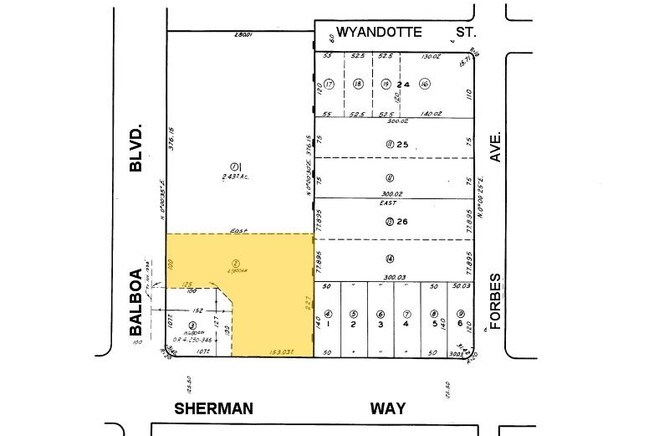
7220 Balboa Blvd
2226-031-002
TRACT # 18148 LOT COM AT INTERSECTION OF N LINE OF SHERMAN WAY WITH E LINE OF LOT 1 TH W ON SD N LINE TO A LINE PARALLEL WITH AND DIST E AT R/A 152 FT FROM W LINE OF LOT 57 TR # 1338 TH N 100 FT TH FT TH S 227 FT TO BEG PART OF LOT 1
Restaurantdrivein
Los Angeles
LAC2
California
B and X Area of moderate flood hazard, usually the area between the limits of the 100-year and 500-year floods.
1
2025
1.10 AC
2025
Western SFV
132102
Los Angeles
3,237 SF
Los Angeles-Long Beach-Glendale, CA
NEARBY LISTINGS FOR SALE OR LEASE
DEMOGRAPHICS near 7220 Balboa Blvd
1 mile
3 mile
5 mile
2025 Total Population
21,928
272,187
688,737
2030 Population
21,876
273,003
688,271
Pop Growth 2025-2030
(0.24%)
+ 0.30%
(0.07%)
Average Age
41
40
40
2025 Total Households
7,460
90,728
230,185
HH Growth 2025-2030
(0.39%)
+ 0.07%
(0.28%)
Median Household Inc
$100,293
$74,870
$83,466
Avg Household Size
2.90
2.90
2.90
2025 Avg HH Vehicles
2.00
2.00
2.00
Median Home Value
$767,764
$777,417
$826,832
Median Year Built
1961
1970
1968
Nearby Places
Map Layers
Map Styles
 Street
 Aerial
Layers
 Traffic
 Biking
Places
Listings with unknown addresses are not visible on the map
- Restaurants
- Banks
- Shops
- Fitness
- Groceries
PUBLIC TRANSPORTATION
COMMUTER RAIL
Van Nuys (Ventura County Line - Southern California Regional Rail Authority (Metrolink))
Drive
Walk
Distance
Van Nuys (Ventura County Line - Southern California Regional Rail Authority (Metrolink))
11 min
4.2 mi
Northridge (Ventura County Line - Southern California Regional Rail Authority (Metrolink))
Drive
Walk
Distance
Northridge (Ventura County Line - Southern California Regional Rail Authority (Metrolink))
11 min
4.5 mi
AIRPORT
Bob Hope
Drive
Walk
Distance
Bob Hope
18 min
8.3 mi
Los Angeles International
Drive
Walk
Distance
Los Angeles International
32 min
22.2 mi
Long Beach (Daugherty Field)
Drive
Walk
Distance
Long Beach (Daugherty Field)
51 min
39.6 mi
Freight Ports
Port of Long Beach
Drive
Walk
Distance
Port of Long Beach
54 min
41.5 mi
Nearby Properties
Address
Land Use
TOTAL SIZE
Lot Size
Zoning
Address
Land Use
TOTAL SIZE
Lot Size
Zoning
461,531 SF
11.22 AC
LAC2
Address
Land Use
TOTAL SIZE
Lot Size
Zoning
393,032 SF
70.93 AC
LAM2
Address
Land Use
TOTAL SIZE
Lot Size
Zoning
300,266 SF
7.29 AC
LAR4
Address
Land Use
TOTAL SIZE
Lot Size
Zoning
580,686 SF
8.46 AC
LAR1
Address
Land Use
TOTAL SIZE
Lot Size
Zoning
439,930 SF
22.16 AC
LAM2
Address
Land Use
TOTAL SIZE
Lot Size
Zoning
376,716 SF
3.72 AC
LAC4
Address
Land Use
TOTAL SIZE
Lot Size
Zoning
333,677 SF
3.89 AC
LARAS3
Address
Land Use
TOTAL SIZE
Lot Size
Zoning
257,873 SF
2.52 AC
Address
Land Use
TOTAL SIZE
Lot Size
Zoning
191,058 SF
5.31 AC
LAR3
Address
Land Use
TOTAL SIZE
Lot Size
Zoning
273,911 SF
8.40 AC
LARA
Address
Land Use
TOTAL SIZE
Lot Size
Zoning
396,109 SF
3.45 AC
LAM1
Address
Land Use
TOTAL SIZE
Lot Size
Zoning
318,083 SF
2.36 AC
LAC2
Address
Land Use
TOTAL SIZE
Lot Size
Zoning
149,385 SF
1.29 AC
LAR3
Address
Land Use
TOTAL SIZE
Lot Size
Zoning
168,271 SF
1.23 AC
LAR4
Address
Land Use
TOTAL SIZE
Lot Size
Zoning
210,268 SF
3.82 AC
LAP
Address
Land Use
TOTAL SIZE
Lot Size
Zoning
290,244 SF
5.77 AC
LAR3
Address
Land Use
TOTAL SIZE
Lot Size
Zoning
116,961 SF
3.60 AC
LAR3
Address
Land Use
TOTAL SIZE
Lot Size
Zoning
117,604 SF
2.65 AC
LAR3
Address
Land Use
TOTAL SIZE
Lot Size
Zoning
173,231 SF
1.58 AC
LAR3
Address
Land Use
TOTAL SIZE
Lot Size
Zoning
290,254 SF
11.53 AC
LAM2
Address
Land Use
TOTAL SIZE
Lot Size
Zoning
221,153 SF
2 AC
LAC4
Address
Land Use
TOTAL SIZE
Lot Size
Zoning
408,735 SF
LAC2
Address
Land Use
TOTAL SIZE
Lot Size
Zoning
138,260 SF
1.29 AC
LAC2
Address
Land Use
TOTAL SIZE
Lot Size
Zoning
250,462 SF
1.85 AC
LAP
Address
Land Use
TOTAL SIZE
Lot Size
Zoning
124,534 SF
7.47 AC
LAC2
Address
Land Use
TOTAL SIZE
Lot Size
Zoning
428,845 SF
4.15 AC
LACM
Address
Land Use
TOTAL SIZE
Lot Size
Zoning
95,584 SF
4.27 AC
LAM1
Address
Land Use
TOTAL SIZE
Lot Size
Zoning
134,103 SF
1 AC
LAC2
Address
Land Use
TOTAL SIZE
Lot Size
Zoning
146,790 SF
1.85 AC
LAR3
Address
Land Use
TOTAL SIZE
Lot Size
Zoning
155,748 SF
1.33 AC
LAR3
The World's #1 Commercial Real Estate Marketplace
Connect with us
© 2026 CoStar Group
The information above has been obtained from sources believed reliable. While we do not doubt its accuracy we have not verified it and make no guarantee, warranty or representation about it. It is your responsibility to independently confirm its accuracy and completeness. Any projections, opinions, assumptions, or estimates used are for example only and do not represent the current or future performance of the property. The value of this transaction to you depends on tax and other factors which should be evaluated by your tax, financial, and legal advisors. You and your advisors should conduct a careful, independent investigation of the property to determine to your satisfaction the suitability of the property for your needs.