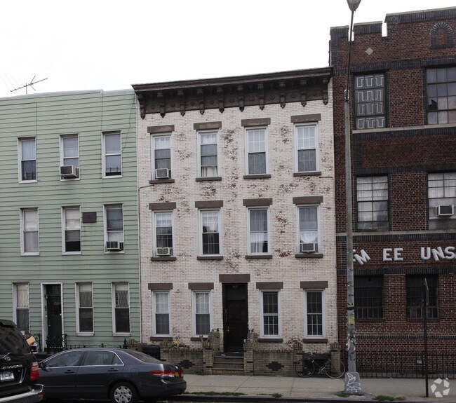
Property Record
724 Metropolitan Ave, Brooklyn, NY 11211

Property Detail
724 Metropolitan Ave
02764-0019
DOCID-2023061300257001
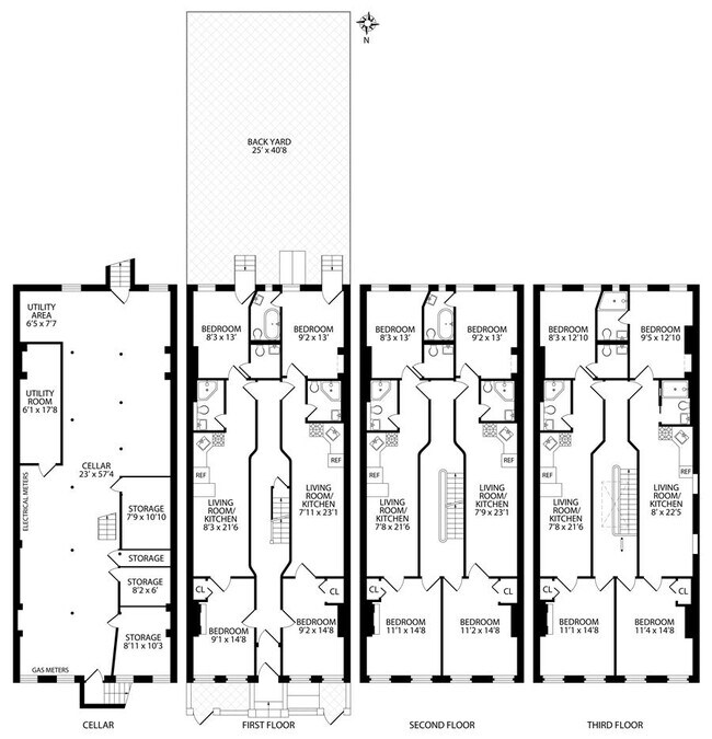
Multifamilydwelling
Kings
R7A
New York
B and X Area of moderate flood hazard, usually the area between the limits of the 100-year and 500-year floods.
19
2025
0.06 AC
2026
Williamsburg
049700
Long Island (New York)
5,700 SF
New York-Jersey City-White Plains, NY-NJ
NEARBY LISTINGS FOR SALE OR LEASE
DEMOGRAPHICS near 724 Metropolitan Ave
1 mile
3 mile
5 mile
2025 Total Population
146,465
1,319,450
3,354,353
2030 Population
148,757
1,342,810
3,402,625
Pop Growth 2025-2030
+ 1.56%
+ 1.77%
+ 1.44%
Average Age
36
38
40
2025 Total Households
61,091
561,219
1,422,624
HH Growth 2025-2030
+ 1.23%
+ 1.94%
+ 1.89%
Median Household Inc
$101,355
$98,276
$100,755
Avg Household Size
2.30
2.20
2.20
2025 Avg HH Vehicles
.00
.00
.00
Median Home Value
$1,043,952
$963,077
$934,729
Median Year Built
1959
1951
1952
Nearby Places
Map Layers
Map Styles
 Street
 Aerial
Layers
 Traffic
 Biking
Places
Listings with unknown addresses are not visible on the map
- Restaurants
- Banks
- Shops
- Fitness
- Groceries
PUBLIC TRANSPORTATION
COMMUTER RAIL
Hunterspoint Avenue Station (Hempstead Branch - Long Island Rail Road, Oyster Bay Branch - Long Island Rail Road)
Drive
Walk
Distance
Hunterspoint Avenue Station (Hempstead Branch - Long Island Rail Road, Oyster Bay Branch - Long Island Rail Road)
8 min
2.4 mi
Long Island City Station (Hempstead Branch - Long Island Rail Road)
Drive
Walk
Distance
Long Island City Station (Hempstead Branch - Long Island Rail Road)
9 min
2.6 mi
AIRPORT
LaGuardia
Drive
Walk
Distance
LaGuardia
14 min
7.1 mi
John F Kennedy International
Drive
Walk
Distance
John F Kennedy International
24 min
14.4 mi
Newark Liberty International
Drive
Walk
Distance
Newark Liberty International
27 min
15.3 mi
Freight Ports
NY - Red Hook Container Terminal
Drive
Walk
Distance
NY - Red Hook Container Terminal
10 min
5.0 mi
SALE & LEASE HISTORY
LISTING DATE
SALE/LEASE

Jun 23, 2022
For Sale
Nearby Properties
Address
Land Use
TOTAL SIZE
Lot Size
Zoning
Address
Land Use
TOTAL SIZE
Lot Size
Zoning
8,462,176 SF
61.41 AC
R7-2
Address
Land Use
TOTAL SIZE
Lot Size
Zoning
940,000 SF
1.44 AC
C6-2
Address
Land Use
TOTAL SIZE
Lot Size
Zoning
2,812,739 SF
2.10 AC
C5-3
Address
Land Use
TOTAL SIZE
Lot Size
Zoning
2,400,000 SF
15.14 AC
C5-2
Address
Land Use
TOTAL SIZE
Lot Size
Zoning
2,124,441 SF
17.29 AC
R8
Address
Land Use
TOTAL SIZE
Lot Size
Zoning
1,233,394 SF
1.78 AC
C5-3
Address
Land Use
TOTAL SIZE
Lot Size
Zoning
1,104,505 SF
2.32 AC
C4-7
Address
Land Use
TOTAL SIZE
Lot Size
Zoning
7,058,736 SF
147.61 AC
M3-1
Address
Land Use
TOTAL SIZE
Lot Size
Zoning
910,736 SF
1.44 AC
C6-2
Address
Land Use
TOTAL SIZE
Lot Size
Zoning
1,166,710 SF
4.22 AC
C1-7
Address
Land Use
TOTAL SIZE
Lot Size
Zoning
3,122,165 SF
19.02 AC
R7-2
Address
Land Use
TOTAL SIZE
Lot Size
Zoning
1,385,425 SF
6.43 AC
R8
Address
Land Use
TOTAL SIZE
Lot Size
Zoning
1,065,915 SF
2.13 AC
M16R10
Address
Land Use
TOTAL SIZE
Lot Size
Zoning
1,503,235 SF
5.28 AC
C2-7
Address
Land Use
TOTAL SIZE
Lot Size
Zoning
840,000 SF
1.04 AC
C4-6
Address
Land Use
TOTAL SIZE
Lot Size
Zoning
805,287 SF
1 AC
R10
Address
Land Use
TOTAL SIZE
Lot Size
Zoning
666,376 SF
0.80 AC
C5-3
Address
Land Use
TOTAL SIZE
Lot Size
Zoning
879,916 SF
1.35 AC
C6-4
Address
Land Use
TOTAL SIZE
Lot Size
Zoning
1,159,795 SF
1.93 AC
C5-3
Address
Land Use
TOTAL SIZE
Lot Size
Zoning
898,734 SF
1.11 AC
C5-3
Address
Land Use
TOTAL SIZE
Lot Size
Zoning
984,760 SF
2.04 AC
M3-1
Address
Land Use
TOTAL SIZE
Lot Size
Zoning
2,948,300 SF
27.71 AC
R7-2
Address
Land Use
TOTAL SIZE
Lot Size
Zoning
986,431 SF
1.06 AC
C52.5
Address
Land Use
TOTAL SIZE
Lot Size
Zoning
890,142 SF
2.22 AC
R7-1
Address
Land Use
TOTAL SIZE
Lot Size
Zoning
818,726 SF
1.65 AC
C1-9
Address
Land Use
TOTAL SIZE
Lot Size
Zoning
385,831 SF
0.83 AC
C6-3
Address
Land Use
TOTAL SIZE
Lot Size
Zoning
450,727 SF
0.45 AC
C5-3
Address
Land Use
TOTAL SIZE
Lot Size
Zoning
722,817 SF
3.26 AC
R8
Address
Land Use
TOTAL SIZE
Lot Size
Zoning
842,881 SF
0.93 AC
C5-2
Address
Land Use
TOTAL SIZE
Lot Size
Zoning
383,780 SF
C6-2
The World's #1 Commercial Real Estate Marketplace
Connect with us
© 2026 CoStar Group
The information above has been obtained from sources believed reliable. While we do not doubt its accuracy we have not verified it and make no guarantee, warranty or representation about it. It is your responsibility to independently confirm its accuracy and completeness. Any projections, opinions, assumptions, or estimates used are for example only and do not represent the current or future performance of the property. The value of this transaction to you depends on tax and other factors which should be evaluated by your tax, financial, and legal advisors. You and your advisors should conduct a careful, independent investigation of the property to determine to your satisfaction the suitability of the property for your needs.