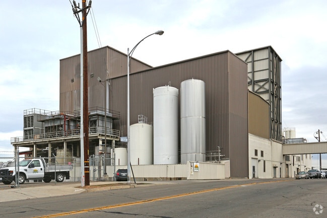
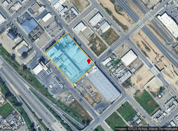
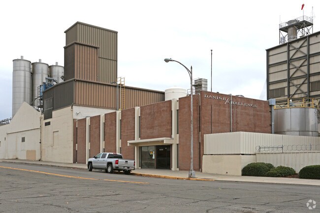
Property Record
725 F St, Fresno, CA 93706
NEARBY LISTINGS FOR SALE OR LEASE
Property Detail
725 F St
467-076-17
City/Fresno
Lightindustrial
3.37 AC & POR RD BLK 36 & ABD ST & ALLEY FRS CITY
X
Fresno
06019C2110H
California
2025
3.37 AC
2025
Downtown
000300
Fresno
101,510 SF
Fresno, CA
DEMOGRAPHICS near 725 F St
1 Mile
3 Mile
5 Mile
2024 Total Population
15,055
117,157
280,318
2029 Population
15,250
119,132
285,230
Pop Growth 2024-2029
+ 1.30%
+ 1.69%
+ 1.75%
Average Age
34
34
34
2024 Total Households
3,788
33,554
83,886
HH Growth 2024-2029
+ 1.48%
+ 1.72%
+ 1.78%
Median Household Inc
$25,996
$35,161
$42,240
Avg Household Size
3.00
3.20
3.20
2024 Avg HH Vehicles
1.00
2.00
2.00
Median Home Value
$224,903
$204,019
$239,200
Median Year Built
1967
1960
1963
Nearby Places
Map Layers
Map Styles
 Street
 Aerial
- Restaurants
- Banks
- Shops
- Fitness
- Groceries
PUBLIC TRANSPORTATION
COMMUTER RAIL
Fresno (San Joaquins - Amtrak)
DRIVE
WALK
Distance
Fresno (San Joaquins - Amtrak)
3 min
1.2 mi
AIRPORT
Fresno Yosemite International
DRIVE
WALK
Distance
Fresno Yosemite International
12 min
7.0 mi
Freight Ports
Port of Stockton
DRIVE
WALK
Distance
Port of Stockton
150 min
127.8 mi
Nearby Properties
Address
Land Use
TOTAL SIZE
Lot Size
Zoning
Address
Land Use
TOTAL SIZE
Lot Size
Zoning
226,597 SF
12.80 AC
M3
Address
Land Use
TOTAL SIZE
Lot Size
Zoning
534,993 SF
5.23 AC
CP
Address
Land Use
TOTAL SIZE
Lot Size
Zoning
0.01 AC
P
Address
Land Use
TOTAL SIZE
Lot Size
Zoning
288,597 SF
1.18 AC
C4
Address
Land Use
TOTAL SIZE
Lot Size
Zoning
147,101 SF
6.31 AC
SPLIT
Address
Land Use
TOTAL SIZE
Lot Size
Zoning
184,130 SF
1.87 AC
PI
Address
Land Use
TOTAL SIZE
Lot Size
Zoning
141,959 SF
35.39 AC
SPLIT
Address
Land Use
TOTAL SIZE
Lot Size
Zoning
176,926 SF
9.79 AC
IH
Address
Land Use
TOTAL SIZE
Lot Size
Zoning
291,527 SF
28.85 AC
M3
Address
Land Use
TOTAL SIZE
Lot Size
Zoning
193,440 SF
16.82 AC
Address
Land Use
TOTAL SIZE
Lot Size
Zoning
238,160 SF
18.77 AC
M3
Address
Land Use
TOTAL SIZE
Lot Size
Zoning
471,760 SF
1.98 AC
CP
Address
Land Use
TOTAL SIZE
Lot Size
Zoning
213,874 SF
4.17 AC
SPLIT
Address
Land Use
TOTAL SIZE
Lot Size
Zoning
206,766 SF
17.11 AC
R2
Address
Land Use
TOTAL SIZE
Lot Size
Zoning
259,852 SF
56.49 AC
AE20
Address
Land Use
TOTAL SIZE
Lot Size
Zoning
61,575 SF
3.50 AC
SPLIT
Address
Land Use
TOTAL SIZE
Lot Size
Zoning
198,436 SF
20.85 AC
M3
Address
Land Use
TOTAL SIZE
Lot Size
Zoning
79,518 SF
2.03 AC
R4
Address
Land Use
TOTAL SIZE
Lot Size
Zoning
409,374 SF
24.73 AC
SPLIT
Address
Land Use
TOTAL SIZE
Lot Size
Zoning
480,570 SF
2.98 AC
P
Address
Land Use
TOTAL SIZE
Lot Size
Zoning
90,500 SF
1.29 AC
CM
Address
Land Use
TOTAL SIZE
Lot Size
Zoning
54,526 SF
5.88 AC
M3
Address
Land Use
TOTAL SIZE
Lot Size
Zoning
314,915 SF
14.12 AC
M2
Address
Land Use
TOTAL SIZE
Lot Size
Zoning
569,220 SF
23.46 AC
SPLIT
Address
Land Use
TOTAL SIZE
Lot Size
Zoning
55,200 SF
14.94 AC
M3
Address
Land Use
TOTAL SIZE
Lot Size
Zoning
96,012 SF
1.33 AC
C4
Address
Land Use
TOTAL SIZE
Lot Size
Zoning
82,096 SF
0.26 AC
C4
Address
Land Use
TOTAL SIZE
Lot Size
Zoning
104,036 SF
6.73 AC
M3
Address
Land Use
TOTAL SIZE
Lot Size
Zoning
96,012 SF
0.60 AC
C4
The World's #1 Commercial Real Estate Marketplace
Connect with us
© 2025 CoStar Group
The information above has been obtained from sources believed reliable. While we do not doubt its accuracy we have not verified it and make no guarantee, warranty or representation about it. It is your responsibility to independently confirm its accuracy and completeness. Any projections, opinions, assumptions, or estimates used are for example only and do not represent the current or future performance of the property. The value of this transaction to you depends on tax and other factors which should be evaluated by your tax, financial, and legal advisors. You and your advisors should conduct a careful, independent investigation of the property to determine to your satisfaction the suitability of the property for your needs.