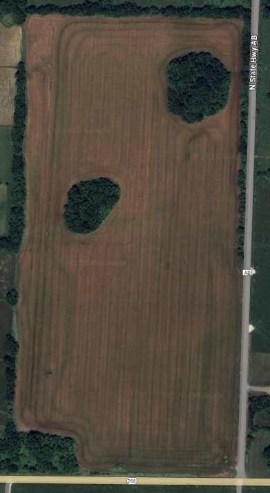
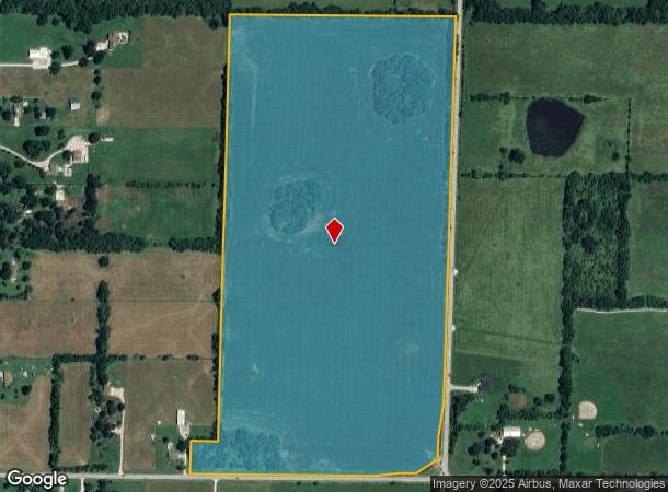
Property Record
7265 W State Highway 266, Springfield, MO 65802
NEARBY LISTINGS FOR SALE OR LEASE
-
-
-
-
-
-
-
West Chestnut Expressway @ Chestnut Expressway and I-44
Springfield, MO 65802
Rent Upon Request
2.10 - 8.80 AC Lot
Land
-
View all Springfield listings for lease on LoopNet.com
Property Detail
7265 W State Highway 266
Springfield, MO
Greene
14-15-300-001
Missouri
Sfr
79.63 AC
X
Outlying Greene County
29077C0308E
Springfield
1,092 SF
DEMOGRAPHICS near 7265 W State Highway 266
1 Mile
3 Mile
5 Mile
2024 Total Population
459
5,146
22,474
2029 Population
472
5,296
23,072
Pop Growth 2024-2029
+ 2.83%
+ 2.91%
+ 2.66%
Average Age
42
40
39
2024 Total Households
170
1,925
8,673
HH Growth 2024-2029
+ 2.94%
+ 3.06%
+ 2.80%
Median Household Inc
$76,786
$84,174
$66,937
Avg Household Size
2.60
2.60
2.50
2024 Avg HH Vehicles
3.00
2.00
2.00
Median Home Value
$229,452
$208,474
$178,109
Median Year Built
1984
1990
1994
Nearby Places
Map Layers
Map Styles
 Street
 Aerial
- Restaurants
- Banks
- Shops
- Fitness
- Groceries
PUBLIC TRANSPORTATION
AIRPORT
Springfield-Branson Ntl
DRIVE
WALK
Distance
Springfield-Branson Ntl
15 min
6.5 mi
Freight Ports
Tulsa Port of Inola
DRIVE
WALK
Distance
Tulsa Port of Inola
182 min
164.7 mi
SALE & LEASE HISTORY
LISTING DATE
SALE/LEASE

Jul 15, 2024
For Lease
Nearby Properties
Address
Land Use
TOTAL SIZE
Lot Size
Zoning
Address
Land Use
TOTAL SIZE
Lot Size
Zoning
82.16 AC
Address
Land Use
TOTAL SIZE
Lot Size
Zoning
154,470 SF
16.97 AC
INC
Address
Land Use
TOTAL SIZE
Lot Size
Zoning
8.12 AC
INC
Address
Land Use
TOTAL SIZE
Lot Size
Zoning
28.99 AC
Address
Land Use
TOTAL SIZE
Lot Size
Zoning
7.95 AC
INC
Address
Land Use
TOTAL SIZE
Lot Size
Zoning
13.80 AC
C-2
Address
Land Use
TOTAL SIZE
Lot Size
Zoning
Address
Land Use
TOTAL SIZE
Lot Size
Zoning
11.87 AC
INC
Address
Land Use
TOTAL SIZE
Lot Size
Zoning
12.44 AC
Address
Land Use
TOTAL SIZE
Lot Size
Zoning
Address
Land Use
TOTAL SIZE
Lot Size
Zoning
13.42 AC
INC
Address
Land Use
TOTAL SIZE
Lot Size
Zoning
3.12 AC
INC
Address
Land Use
TOTAL SIZE
Lot Size
Zoning
7.19 AC
O-2
Address
Land Use
TOTAL SIZE
Lot Size
Zoning
54.58 AC
INC
Address
Land Use
TOTAL SIZE
Lot Size
Zoning
42,650 SF
19.04 AC
M-2
Address
Land Use
TOTAL SIZE
Lot Size
Zoning
44,522 SF
12 AC
INC
Address
Land Use
TOTAL SIZE
Lot Size
Zoning
99,756 SF
10.60 AC
M-1
Address
Land Use
TOTAL SIZE
Lot Size
Zoning
5.45 AC
INC
Address
Land Use
TOTAL SIZE
Lot Size
Zoning
1,667 SF
27.19 AC
M-1
Address
Land Use
TOTAL SIZE
Lot Size
Zoning
25,260 SF
9.09 AC
INC
Address
Land Use
TOTAL SIZE
Lot Size
Zoning
8.98 AC
INC
Address
Land Use
TOTAL SIZE
Lot Size
Zoning
14.67 AC
PAD
Address
Land Use
TOTAL SIZE
Lot Size
Zoning
3.64 AC
M-1
Address
Land Use
TOTAL SIZE
Lot Size
Zoning
128.07 AC
INC
Address
Land Use
TOTAL SIZE
Lot Size
Zoning
3.60 AC
INC
Address
Land Use
TOTAL SIZE
Lot Size
Zoning
Address
Land Use
TOTAL SIZE
Lot Size
Zoning
11,280 SF
4.75 AC
O-2
Address
Land Use
TOTAL SIZE
Lot Size
Zoning
Address
Land Use
TOTAL SIZE
Lot Size
Zoning
33,900 SF
4.60 AC
M-1
Address
Land Use
TOTAL SIZE
Lot Size
Zoning
20.79 AC
INC
The World's #1 Commercial Real Estate Marketplace
Connect with us
© 2025 CoStar Group
The information above has been obtained from sources believed reliable. While we do not doubt its accuracy we have not verified it and make no guarantee, warranty or representation about it. It is your responsibility to independently confirm its accuracy and completeness. Any projections, opinions, assumptions, or estimates used are for example only and do not represent the current or future performance of the property. The value of this transaction to you depends on tax and other factors which should be evaluated by your tax, financial, and legal advisors. You and your advisors should conduct a careful, independent investigation of the property to determine to your satisfaction the suitability of the property for your needs.