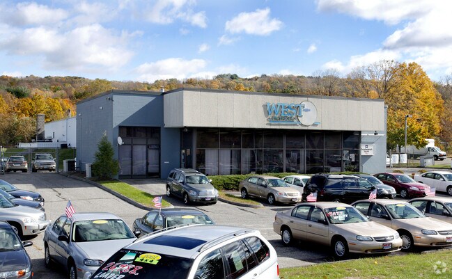
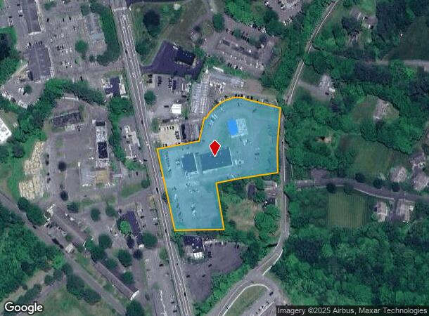
Property Record
729 Main St S, Woodbury, CT 06798
NEARBY LISTINGS FOR SALE OR LEASE
Property Detail
729 Main St S
Torrington, CT
Litchfield
WOOD M:102 B:041A L:A&B&C
Connecticut
Commercialnec
a,b,c
2025
3.87 AC
2025
New Milford/SW Litchfield
362101
Hartford
DEMOGRAPHICS near 729 Main St S
1 Mile
3 Mile
5 Mile
2024 Total Population
1,215
11,435
29,120
2029 Population
1,199
11,309
28,975
Pop Growth 2024-2029
(1.32%)
(1.10%)
(0.50%)
Average Age
46
48
49
2024 Total Households
592
5,193
12,504
HH Growth 2024-2029
(1.35%)
(1.31%)
(0.80%)
Median Household Inc
$76,302
$94,846
$104,987
Avg Household Size
2.10
2.20
2.30
2024 Avg HH Vehicles
2.00
2.00
2.00
Median Home Value
$402,326
$406,676
$395,944
Median Year Built
1974
1975
1976
Nearby Places
Map Layers
Map Styles
 Street
 Aerial
- Restaurants
- Banks
- Shops
- Fitness
- Groceries
PUBLIC TRANSPORTATION
AIRPORT
Tweed/New Haven
DRIVE
WALK
Distance
Tweed/New Haven
53 min
29.8 mi
Freight Ports
Port of New Haven
DRIVE
WALK
Distance
Port of New Haven
48 min
27.0 mi
Nearby Properties
Address
Land Use
TOTAL SIZE
Lot Size
Zoning
Address
Land Use
TOTAL SIZE
Lot Size
Zoning
102.26 AC
OS60
Address
Land Use
TOTAL SIZE
Lot Size
Zoning
207,001 SF
60.66 AC
M-2
Address
Land Use
TOTAL SIZE
Lot Size
Zoning
185,641 SF
22.35 AC
PDD
Address
Land Use
TOTAL SIZE
Lot Size
Zoning
102,487 SF
22 AC
R40
Address
Land Use
TOTAL SIZE
Lot Size
Zoning
36.62 AC
L200
Address
Land Use
TOTAL SIZE
Lot Size
Zoning
3,744 SF
23.33 AC
OS60
Address
Land Use
TOTAL SIZE
Lot Size
Zoning
227.23 AC
EE
Address
Land Use
TOTAL SIZE
Lot Size
Zoning
59,250 SF
9.30 AC
R40
Address
Land Use
TOTAL SIZE
Lot Size
Zoning
2,520 SF
92.96 AC
EE
Address
Land Use
TOTAL SIZE
Lot Size
Zoning
142,146 SF
6.63 AC
B-2
Address
Land Use
TOTAL SIZE
Lot Size
Zoning
5.51 AC
MSD
Address
Land Use
TOTAL SIZE
Lot Size
Zoning
68,970 SF
10.50 AC
R-60
Address
Land Use
TOTAL SIZE
Lot Size
Zoning
32,264 SF
15.92 AC
R-60
Address
Land Use
TOTAL SIZE
Lot Size
Zoning
21,762 SF
1.76 AC
MSD
Address
Land Use
TOTAL SIZE
Lot Size
Zoning
86,000 SF
7.19 AC
B-3
Address
Land Use
TOTAL SIZE
Lot Size
Zoning
5.51 AC
R40
Address
Land Use
TOTAL SIZE
Lot Size
Zoning
3.73 AC
R-60
Address
Land Use
TOTAL SIZE
Lot Size
Zoning
7,088 SF
30.67 AC
R80
Address
Land Use
TOTAL SIZE
Lot Size
Zoning
12.31 AC
GA
Address
Land Use
TOTAL SIZE
Lot Size
Zoning
19.53 AC
Address
Land Use
TOTAL SIZE
Lot Size
Zoning
6.81 AC
MSD
Address
Land Use
TOTAL SIZE
Lot Size
Zoning
50,937 SF
7.25 AC
GI40
Address
Land Use
TOTAL SIZE
Lot Size
Zoning
7.18 AC
PDD17
Address
Land Use
TOTAL SIZE
Lot Size
Zoning
7.85 AC
OS60
Address
Land Use
TOTAL SIZE
Lot Size
Zoning
22,696 SF
4.86 AC
R-60
Address
Land Use
TOTAL SIZE
Lot Size
Zoning
29,630 SF
3.28 AC
PI
Address
Land Use
TOTAL SIZE
Lot Size
Zoning
2.74 AC
MSD
Address
Land Use
TOTAL SIZE
Lot Size
Zoning
16,819 SF
4.10 AC
MSD
Address
Land Use
TOTAL SIZE
Lot Size
Zoning
3.87 AC
MQ
Address
Land Use
TOTAL SIZE
Lot Size
Zoning
32,260 SF
6.91 AC
GI40
The World's #1 Commercial Real Estate Marketplace
Connect with us
© 2025 CoStar Group
The information above has been obtained from sources believed reliable. While we do not doubt its accuracy we have not verified it and make no guarantee, warranty or representation about it. It is your responsibility to independently confirm its accuracy and completeness. Any projections, opinions, assumptions, or estimates used are for example only and do not represent the current or future performance of the property. The value of this transaction to you depends on tax and other factors which should be evaluated by your tax, financial, and legal advisors. You and your advisors should conduct a careful, independent investigation of the property to determine to your satisfaction the suitability of the property for your needs.