Property Record
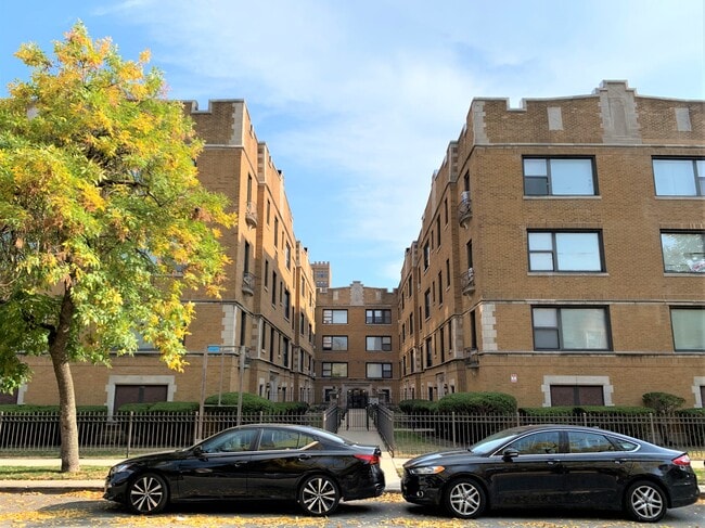
7331 S Coles Ave, Chicago, IL 60649

NEARBY LISTINGS FOR SALE OR LEASE
Property Detail
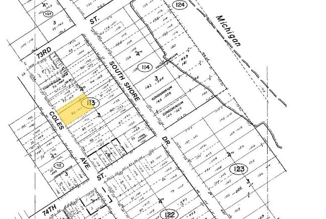
7331 S Coles Ave
Chicago-Naperville-Elgin, IL-IN
South Shore
21-30-113-010-0000
(SOUTH)(SHORE) SUB OF N FRACL HALF OF FRACL OF TOGETH ER WITH A RESUB OF LTS 1 2 4 64 66 126-127 DIV 1 OF WESTFALLS SUB OF 20
Apartment
Cook
X
Illinois
17031C0543K
1
2023
0.44 AC
2025
South Shore
431400
Chicago
26,706 SF
DEMOGRAPHICS near 7331 S Coles Ave
1 Mile
3 Mile
5 Mile
2024 Total Population
42,013
179,786
379,220
2029 Population
41,405
174,851
367,888
Pop Growth 2024-2029
(1.45%)
(2.74%)
(2.99%)
Average Age
40
40
40
2024 Total Households
20,143
80,570
163,295
HH Growth 2024-2029
(1.77%)
(3.01%)
(3.25%)
Median Household Inc
$36,107
$39,008
$39,257
Avg Household Size
2.00
2.10
2.20
2024 Avg HH Vehicles
1.00
1.00
1.00
Median Home Value
$201,639
$202,278
$187,842
Median Year Built
1947
1947
1948
Nearby Places
Map Layers
Map Styles
 Street
 Aerial
- Restaurants
- Banks
- Shops
- Fitness
- Groceries
PUBLIC TRANSPORTATION
COMMUTER RAIL
South Shore Station (Metra Electric Line - Northeast Illinois Regional Commuter Railroad (Metra))
DRIVE
WALK
Distance
South Shore Station (Metra Electric Line - Northeast Illinois Regional Commuter Railroad (Metra))
1 min
7 min
0.4 mi
Windsor Park Station (Metra Electric Line - Northeast Illinois Regional Commuter Railroad (Metra))
DRIVE
WALK
Distance
Windsor Park Station (Metra Electric Line - Northeast Illinois Regional Commuter Railroad (Metra))
1 min
7 min
0.4 mi
AIRPORT
Chicago Midway International
DRIVE
WALK
Distance
Chicago Midway International
22 min
11.8 mi
Chicago O'Hare International
DRIVE
WALK
Distance
Chicago O'Hare International
44 min
28.0 mi
Freight Ports
Port Milwaukee
DRIVE
WALK
Distance
Port Milwaukee
122 min
96.2 mi
SALE & LEASE HISTORY
LISTING DATE
SALE/LEASE

Nov 01, 2016
For Sale
Mar 28, 2023
For Sale
Nearby Properties
Address
Land Use
TOTAL SIZE
Lot Size
Zoning
Address
Land Use
TOTAL SIZE
Lot Size
Zoning
0.49 AC
SLI
Address
Land Use
TOTAL SIZE
Lot Size
Zoning
Address
Land Use
TOTAL SIZE
Lot Size
Zoning
0.28 AC
PD 38
Address
Land Use
TOTAL SIZE
Lot Size
Zoning
109,145 SF
0.46 AC
RM-5
Address
Land Use
TOTAL SIZE
Lot Size
Zoning
115,000 SF
1.97 AC
C1-2
Address
Land Use
TOTAL SIZE
Lot Size
Zoning
Address
Land Use
TOTAL SIZE
Lot Size
Zoning
62,216 SF
0.65 AC
RM-5
Address
Land Use
TOTAL SIZE
Lot Size
Zoning
2.65 AC
PD 38
Address
Land Use
TOTAL SIZE
Lot Size
Zoning
115,000 SF
1.12 AC
C1-2
Address
Land Use
TOTAL SIZE
Lot Size
Zoning
156,800 SF
2.65 AC
PD 38
Address
Land Use
TOTAL SIZE
Lot Size
Zoning
PD 43
Address
Land Use
TOTAL SIZE
Lot Size
Zoning
Address
Land Use
TOTAL SIZE
Lot Size
Zoning
451,349 SF
1.62 AC
PD 1062
Address
Land Use
TOTAL SIZE
Lot Size
Zoning
PD 43
Address
Land Use
TOTAL SIZE
Lot Size
Zoning
769,600 SF
PD 282
Address
Land Use
TOTAL SIZE
Lot Size
Zoning
78,000 SF
0.62 AC
RM-5
Address
Land Use
TOTAL SIZE
Lot Size
Zoning
117,557 SF
2.69 AC
B3-3
Address
Land Use
TOTAL SIZE
Lot Size
Zoning
36,365 SF
Address
Land Use
TOTAL SIZE
Lot Size
Zoning
23,799 SF
0.91 AC
PD 571
Address
Land Use
TOTAL SIZE
Lot Size
Zoning
0.84 AC
RM-5
Address
Land Use
TOTAL SIZE
Lot Size
Zoning
156,249 SF
0.57 AC
B3-5
Address
Land Use
TOTAL SIZE
Lot Size
Zoning
293,461 SF
1.19 AC
PD 282
Address
Land Use
TOTAL SIZE
Lot Size
Zoning
15,052 SF
1.03 AC
PQ
Address
Land Use
TOTAL SIZE
Lot Size
Zoning
3.61 AC
B3-3
Address
Land Use
TOTAL SIZE
Lot Size
Zoning
Address
Land Use
TOTAL SIZE
Lot Size
Zoning
145,291 SF
7.85 AC
B3-2
Address
Land Use
TOTAL SIZE
Lot Size
Zoning
289,850 SF
1.46 AC
RM-6
Address
Land Use
TOTAL SIZE
Lot Size
Zoning
25,977 SF
0.46 AC
RM-5
Address
Land Use
TOTAL SIZE
Lot Size
Zoning
184,487 SF
0.66 AC
RM-5,RS-3
Address
Land Use
TOTAL SIZE
Lot Size
Zoning
743,663 SF
7.14 AC
RT-4
The World's #1 Commercial Real Estate Marketplace
Connect with us
© 2026 CoStar Group
The information above has been obtained from sources believed reliable. While we do not doubt its accuracy we have not verified it and make no guarantee, warranty or representation about it. It is your responsibility to independently confirm its accuracy and completeness. Any projections, opinions, assumptions, or estimates used are for example only and do not represent the current or future performance of the property. The value of this transaction to you depends on tax and other factors which should be evaluated by your tax, financial, and legal advisors. You and your advisors should conduct a careful, independent investigation of the property to determine to your satisfaction the suitability of the property for your needs.