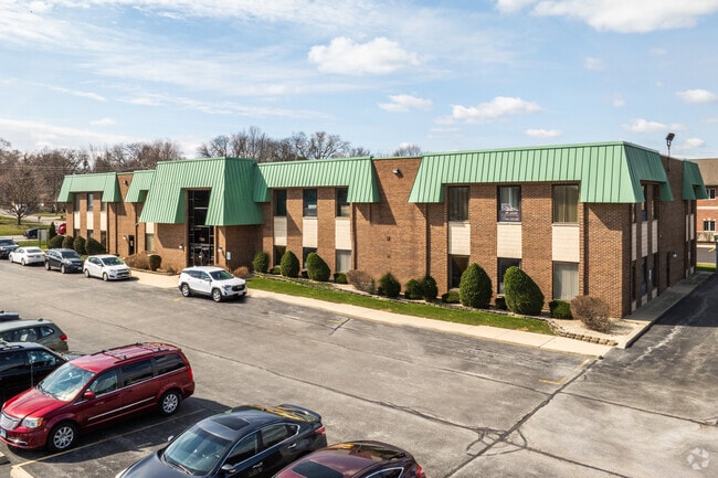
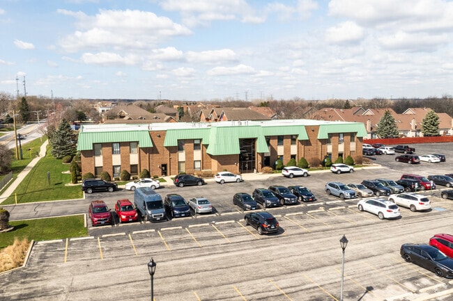
Property Record
7350 W College Dr, Palos Heights, IL 60463

Current Lease Availabilities
NEARBY LISTINGS FOR SALE OR LEASE
Property Detail
7350 W College Dr
23-24-406-015-0000
College Drive & 74Th Ave Su
Storebuilding
Cook
X
Illinois
17031C0616J
2
2023
1.76 AC
2024
South Route 45
823903
Chicago
25,196 SF
Chicago-Naperville-Elgin, IL-IN-WI
DEMOGRAPHICS near 7350 W College Dr
1 Mile
3 Mile
5 Mile
2024 Total Population
8,367
82,264
259,576
2029 Population
8,128
80,208
252,811
Pop Growth 2024-2029
(2.86%)
(2.50%)
(2.61%)
Average Age
45
43
42
2024 Total Households
3,126
32,516
99,240
HH Growth 2024-2029
(3.20%)
(2.72%)
(2.88%)
Median Household Inc
$88,040
$72,188
$73,241
Avg Household Size
2.50
2.50
2.50
2024 Avg HH Vehicles
2.00
2.00
2.00
Median Home Value
$280,270
$258,754
$251,378
Median Year Built
1964
1975
1973
Nearby Places
Map Layers
Map Styles
 Street
 Aerial
- Restaurants
- Banks
- Shops
- Fitness
- Groceries
PUBLIC TRANSPORTATION
COMMUTER RAIL
Palos Park Station (SouthWest Service - Northeast Illinois Regional Commuter Railroad (Metra))
DRIVE
WALK
Distance
Palos Park Station (SouthWest Service - Northeast Illinois Regional Commuter Railroad (Metra))
4 min
1.4 mi
Worth Station (SouthWest Service - Northeast Illinois Regional Commuter Railroad (Metra))
DRIVE
WALK
Distance
Worth Station (SouthWest Service - Northeast Illinois Regional Commuter Railroad (Metra))
3 min
1.5 mi
AIRPORT
Chicago Midway International
DRIVE
WALK
Distance
Chicago Midway International
19 min
10.9 mi
Chicago O'Hare International
DRIVE
WALK
Distance
Chicago O'Hare International
42 min
29.7 mi
Nearby Properties
Address
Land Use
TOTAL SIZE
Lot Size
Zoning
Address
Land Use
TOTAL SIZE
Lot Size
Zoning
Address
Land Use
TOTAL SIZE
Lot Size
Zoning
23.81 AC
Address
Land Use
TOTAL SIZE
Lot Size
Zoning
191,763 SF
15.63 AC
Address
Land Use
TOTAL SIZE
Lot Size
Zoning
495,815 SF
20.78 AC
Address
Land Use
TOTAL SIZE
Lot Size
Zoning
401,021 SF
27.42 AC
Address
Land Use
TOTAL SIZE
Lot Size
Zoning
510,332 SF
23.97 AC
Address
Land Use
TOTAL SIZE
Lot Size
Zoning
34,970 SF
3.87 AC
Address
Land Use
TOTAL SIZE
Lot Size
Zoning
96,469 SF
6.77 AC
Address
Land Use
TOTAL SIZE
Lot Size
Zoning
61,388 SF
2 AC
Address
Land Use
TOTAL SIZE
Lot Size
Zoning
Address
Land Use
TOTAL SIZE
Lot Size
Zoning
869,275 SF
24.34 AC
Address
Land Use
TOTAL SIZE
Lot Size
Zoning
283,947 SF
13.27 AC
Address
Land Use
TOTAL SIZE
Lot Size
Zoning
320,038 SF
13.04 AC
Address
Land Use
TOTAL SIZE
Lot Size
Zoning
127,984 SF
12.76 AC
Address
Land Use
TOTAL SIZE
Lot Size
Zoning
67,488 SF
10 AC
Address
Land Use
TOTAL SIZE
Lot Size
Zoning
261,520 SF
13.59 AC
Address
Land Use
TOTAL SIZE
Lot Size
Zoning
567,900 SF
15.07 AC
Address
Land Use
TOTAL SIZE
Lot Size
Zoning
43,271 SF
2.09 AC
Address
Land Use
TOTAL SIZE
Lot Size
Zoning
115,850 SF
10.08 AC
Address
Land Use
TOTAL SIZE
Lot Size
Zoning
137,386 SF
4.96 AC
Address
Land Use
TOTAL SIZE
Lot Size
Zoning
Address
Land Use
TOTAL SIZE
Lot Size
Zoning
465,003 SF
27.21 AC
Address
Land Use
TOTAL SIZE
Lot Size
Zoning
50,151 SF
2.85 AC
Address
Land Use
TOTAL SIZE
Lot Size
Zoning
171,624 SF
23.56 AC
Address
Land Use
TOTAL SIZE
Lot Size
Zoning
228,900 SF
20 AC
Address
Land Use
TOTAL SIZE
Lot Size
Zoning
169,100 SF
4.43 AC
Address
Land Use
TOTAL SIZE
Lot Size
Zoning
215,769 SF
9.96 AC
Address
Land Use
TOTAL SIZE
Lot Size
Zoning
122,619 SF
18.30 AC
Address
Land Use
TOTAL SIZE
Lot Size
Zoning
76,891 SF
4.69 AC
Address
Land Use
TOTAL SIZE
Lot Size
Zoning
144,653 SF
6.66 AC
The World's #1 Commercial Real Estate Marketplace
Connect with us
© 2025 CoStar Group
The information above has been obtained from sources believed reliable. While we do not doubt its accuracy we have not verified it and make no guarantee, warranty or representation about it. It is your responsibility to independently confirm its accuracy and completeness. Any projections, opinions, assumptions, or estimates used are for example only and do not represent the current or future performance of the property. The value of this transaction to you depends on tax and other factors which should be evaluated by your tax, financial, and legal advisors. You and your advisors should conduct a careful, independent investigation of the property to determine to your satisfaction the suitability of the property for your needs.