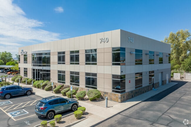
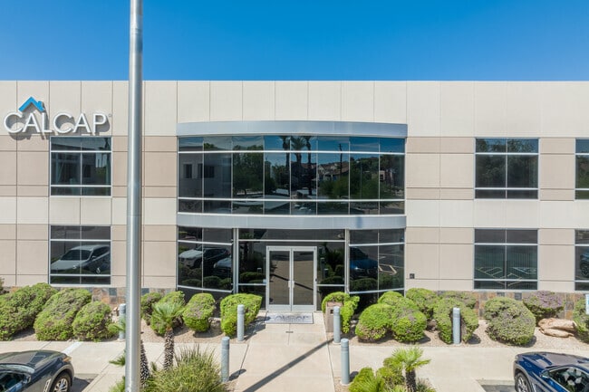
Property Record
740 N 52Nd St, Phoenix, AZ 85008

Save to a Folder
{{folder.Name}}
{{folder.ListingIds.length}} Properties
{{folder.ListingIds.length}} Property
Create a New Folder
Property Detail
740 N 52Nd St
125-06-068
PAPAGO COMMERCE PARK MCR 592-01
Officebuilding
Maricopa
C-O
Arizona
C and X Area of minimal flood hazard, usually depicted on FIRMs as above the 500-year flood level.
1
2025
1.21 AC
2025
44th Street Corridor
111202
Phoenix
14,840 SF
Phoenix-Mesa-Chandler, AZ
NEARBY LISTINGS FOR SALE OR LEASE
DEMOGRAPHICS near 740 N 52Nd St
1 mile
3 mile
5 mile
2025 Total Population
13,795
124,596
342,298
2030 Population
14,459
130,663
358,751
Pop Growth 2025-2030
+ 4.81%
+ 4.87%
+ 4.81%
Average Age
33
35
37
2025 Total Households
6,791
53,516
148,782
HH Growth 2025-2030
+ 5.11%
+ 5.11%
+ 5.17%
Median Household Inc
$66,213
$72,260
$74,569
Avg Household Size
2.00
2.20
2.20
2025 Avg HH Vehicles
1.00
2.00
2.00
Median Home Value
$336,776
$569,402
$554,467
Median Year Built
1991
1981
1978
Nearby Places
Map Layers
Map Styles
 Street
 Aerial
Layers
 Traffic
 Biking
Places
Listings with unknown addresses are not visible on the map
- Restaurants
- Banks
- Shops
- Fitness
- Groceries
PUBLIC TRANSPORTATION
TRANSIT/SUBWAY
50Th St/Washington St (Valley Metro Rail - Valley Metro (Phoenix Light Rail))
Drive
Walk
Distance
50Th St/Washington St (Valley Metro Rail - Valley Metro (Phoenix Light Rail))
3 min
20 min
1.0 mi
AIRPORT
Phoenix Sky Harbor International
Drive
Walk
Distance
Phoenix Sky Harbor International
8 min
3.8 mi
Phoenix-Mesa Gateway
Drive
Walk
Distance
Phoenix-Mesa Gateway
39 min
27.2 mi
Freight Ports
Port of San Diego
Drive
Walk
Distance
Port of San Diego
401 min
360.8 mi
SALE & LEASE HISTORY
LISTING DATE
SALE/LEASE

Sep 18, 2018
For Sale
May 22, 2019
For Lease
Jun 30, 2025
For Lease
Jun 23, 2025
For Sale
Jan 14, 2019
For Lease
Nearby Properties
Address
Land Use
TOTAL SIZE
Lot Size
Zoning
Address
Land Use
TOTAL SIZE
Lot Size
Zoning
4.59 AC
I-1
Address
Land Use
TOTAL SIZE
Lot Size
Zoning
2,901,193 SF
20.73 AC
A-1
Address
Land Use
TOTAL SIZE
Lot Size
Zoning
75,000 SF
12.19 AC
I-1
Address
Land Use
TOTAL SIZE
Lot Size
Zoning
103,415 SF
4.61 AC
C-T
Address
Land Use
TOTAL SIZE
Lot Size
Zoning
1,949,842 SF
40 AC
I-1
Address
Land Use
TOTAL SIZE
Lot Size
Zoning
2.63 AC
I-1
Address
Land Use
TOTAL SIZE
Lot Size
Zoning
111,886 SF
3.46 AC
C-G
Address
Land Use
TOTAL SIZE
Lot Size
Zoning
3.62 AC
Address
Land Use
TOTAL SIZE
Lot Size
Zoning
Address
Land Use
TOTAL SIZE
Lot Size
Zoning
199,677 SF
14.55 AC
C-3
Address
Land Use
TOTAL SIZE
Lot Size
Zoning
401,544 SF
64.59 AC
GID
Address
Land Use
TOTAL SIZE
Lot Size
Zoning
2,089,643 SF
33.80 AC
MU-ED
Address
Land Use
TOTAL SIZE
Lot Size
Zoning
106,575 SF
2.50 AC
I-1
Address
Land Use
TOTAL SIZE
Lot Size
Zoning
2.54 AC
Address
Land Use
TOTAL SIZE
Lot Size
Zoning
649,656 SF
10.19 AC
PAD
Address
Land Use
TOTAL SIZE
Lot Size
Zoning
4.76 AC
C-G
Address
Land Use
TOTAL SIZE
Lot Size
Zoning
462,201 SF
6.74 AC
I-1
Address
Land Use
TOTAL SIZE
Lot Size
Zoning
522,676 SF
264.16 AC
I-1
Address
Land Use
TOTAL SIZE
Lot Size
Zoning
44,971 SF
2.06 AC
C-R
Address
Land Use
TOTAL SIZE
Lot Size
Zoning
58,061 SF
5.43 AC
C-C
Address
Land Use
TOTAL SIZE
Lot Size
Zoning
697,894 SF
8.43 AC
PAD
Address
Land Use
TOTAL SIZE
Lot Size
Zoning
3,010 SF
35.44 AC
R110
Address
Land Use
TOTAL SIZE
Lot Size
Zoning
76,801 SF
4.79 AC
R1-6
Address
Land Use
TOTAL SIZE
Lot Size
Zoning
498,595 SF
9.01 AC
C-C
Address
Land Use
TOTAL SIZE
Lot Size
Zoning
511,014 SF
5.01 AC
I-1
Address
Land Use
TOTAL SIZE
Lot Size
Zoning
9,344 SF
134.45 AC
R3
The World's #1 Commercial Real Estate Marketplace
Connect with us
© 2026 CoStar Group
The information above has been obtained from sources believed reliable. While we do not doubt its accuracy we have not verified it and make no guarantee, warranty or representation about it. It is your responsibility to independently confirm its accuracy and completeness. Any projections, opinions, assumptions, or estimates used are for example only and do not represent the current or future performance of the property. The value of this transaction to you depends on tax and other factors which should be evaluated by your tax, financial, and legal advisors. You and your advisors should conduct a careful, independent investigation of the property to determine to your satisfaction the suitability of the property for your needs.