Property Record
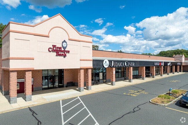
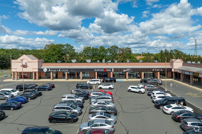
741 Brewers Bridge Rd, Jackson, NJ 08527

Property Detail
741 Brewers Bridge Rd
12-07301-0000-00010
8.59 AC SHOPPING CTR
Commercialnec
OCEAN
HC
New Jersey
B and X Area of moderate flood hazard, usually the area between the limits of the 100-year and 500-year floods.
10
2025
8.59 AC
2025
Ocean County
717002
Northern New Jersey
71,996 SF
Lakewood-New Brunswick, NJ
NEARBY LISTINGS FOR SALE OR LEASE
DEMOGRAPHICS near 741 Brewers Bridge Rd
1 mile
3 mile
5 mile
2025 Total Population
9,309
77,585
167,445
2030 Population
9,380
77,673
166,624
Pop Growth 2025-2030
+ 0.76%
+ 0.11%
(0.49%)
Average Age
31
33
31
2025 Total Households
2,593
21,470
42,696
HH Growth 2025-2030
(0.15%)
(0.65%)
(1.18%)
Median Household Inc
$80,733
$95,398
$90,096
Avg Household Size
3.30
3.30
3.50
2025 Avg HH Vehicles
2.00
2.00
2.00
Median Home Value
$444,320
$472,290
$496,786
Median Year Built
1976
1982
1989
Nearby Places
Map Layers
Map Styles
 Street
 Aerial
Layers
 Traffic
 Biking
Places
Listings with unknown addresses are not visible on the map
- Restaurants
- Banks
- Shops
- Fitness
- Groceries
SALE & LEASE HISTORY
LISTING DATE
SALE/LEASE

Sep 22, 2020
For Lease
Oct 05, 2023
For Lease
Jun 05, 2023
For Lease
Aug 12, 2024
For Lease
Nearby Properties
Address
Land Use
TOTAL SIZE
Lot Size
Zoning
Address
Land Use
TOTAL SIZE
Lot Size
Zoning
113.02 AC
R12
Address
Land Use
TOTAL SIZE
Lot Size
Zoning
155.11 AC
PFE/
Address
Land Use
TOTAL SIZE
Lot Size
Zoning
24.15 AC
MF
Address
Land Use
TOTAL SIZE
Lot Size
Zoning
36,678 SF
38.75 AC
MFAH
Address
Land Use
TOTAL SIZE
Lot Size
Zoning
161,340 SF
35.35 AC
HD-1
Address
Land Use
TOTAL SIZE
Lot Size
Zoning
114,753 SF
45.80 AC
HC
Address
Land Use
TOTAL SIZE
Lot Size
Zoning
237,479 SF
21 AC
LC
Address
Land Use
TOTAL SIZE
Lot Size
Zoning
21,876 SF
22.26 AC
B3
Address
Land Use
TOTAL SIZE
Lot Size
Zoning
14.90 AC
PFE
Address
Land Use
TOTAL SIZE
Lot Size
Zoning
27.47 AC
R1
Address
Land Use
TOTAL SIZE
Lot Size
Zoning
1,032 SF
12.50 AC
HC
Address
Land Use
TOTAL SIZE
Lot Size
Zoning
87,347 SF
10.18 AC
HC
Address
Land Use
TOTAL SIZE
Lot Size
Zoning
18.34 AC
HC
Address
Land Use
TOTAL SIZE
Lot Size
Zoning
17,676 SF
7.25 AC
R15
Address
Land Use
TOTAL SIZE
Lot Size
Zoning
98,518 SF
12.71 AC
HC
Address
Land Use
TOTAL SIZE
Lot Size
Zoning
149,442 SF
11.26 AC
NC
Address
Land Use
TOTAL SIZE
Lot Size
Zoning
28.99 AC
HD-1
Address
Land Use
TOTAL SIZE
Lot Size
Zoning
14.73 AC
R-5
Address
Land Use
TOTAL SIZE
Lot Size
Zoning
37,202 SF
14.79 AC
B3
Address
Land Use
TOTAL SIZE
Lot Size
Zoning
8.08 AC
HC
Address
Land Use
TOTAL SIZE
Lot Size
Zoning
8,784 SF
16.16 AC
R-LM
Address
Land Use
TOTAL SIZE
Lot Size
Zoning
9,180 SF
49.38 AC
OSP
Address
Land Use
TOTAL SIZE
Lot Size
Zoning
56,408 SF
7.39 AC
HC
Address
Land Use
TOTAL SIZE
Lot Size
Zoning
8.43 AC
MF
Address
Land Use
TOTAL SIZE
Lot Size
Zoning
11.05 AC
PRC
Address
Land Use
TOTAL SIZE
Lot Size
Zoning
1,270 SF
3.65 AC
R12
Address
Land Use
TOTAL SIZE
Lot Size
Zoning
112 SF
20.47 AC
HCMF
Address
Land Use
TOTAL SIZE
Lot Size
Zoning
127,932 SF
2.41 AC
R-OP
Address
Land Use
TOTAL SIZE
Lot Size
Zoning
3.64 AC
R10
Address
Land Use
TOTAL SIZE
Lot Size
Zoning
1,930 SF
2.63 AC
R20
The World's #1 Commercial Real Estate Marketplace
Connect with us
© 2026 CoStar Group
The information above has been obtained from sources believed reliable. While we do not doubt its accuracy we have not verified it and make no guarantee, warranty or representation about it. It is your responsibility to independently confirm its accuracy and completeness. Any projections, opinions, assumptions, or estimates used are for example only and do not represent the current or future performance of the property. The value of this transaction to you depends on tax and other factors which should be evaluated by your tax, financial, and legal advisors. You and your advisors should conduct a careful, independent investigation of the property to determine to your satisfaction the suitability of the property for your needs.