Property Record
742 Amity Rd, Bethany, CT 06524

This Property Is For Sale
Property Detail
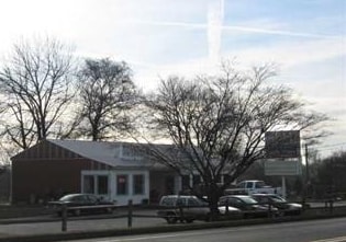
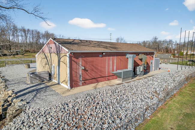
742 Amity Rd
Restaurantbuilding
South Central Ct
B&I
Connecticut
B and X Area of moderate flood hazard, usually the area between the limits of the 100-year and 500-year floods.
0.63 AC
2025
Woodbridge
2025
Westchester/So Connecticut
161100
New Haven, CT
2,092 SF
BETH-000117-000000-000010
NEARBY LISTINGS FOR SALE OR LEASE
DEMOGRAPHICS near 742 Amity Rd
1 mile
3 mile
5 mile
2025 Total Population
1,163
12,474
58,742
2030 Population
1,183
12,826
60,302
Pop Growth 2025-2030
+ 1.72%
+ 2.82%
+ 2.66%
Average Age
46
44
42
2025 Total Households
439
4,799
21,119
HH Growth 2025-2030
+ 1.59%
+ 2.90%
+ 2.76%
Median Household Inc
$168,283
$109,102
$112,551
Avg Household Size
2.60
2.50
2.60
2025 Avg HH Vehicles
3.00
2.00
2.00
Median Home Value
$420,769
$366,573
$371,454
Median Year Built
1970
1979
1974
Nearby Places
Map Layers
Map Styles
 Street
 Aerial
Transit
 Traffic
 Biking
Places
Listings with unknown addresses are not visible on the map
- Restaurants
- Banks
- Shops
- Fitness
- Groceries
PUBLIC TRANSPORTATION
COMMUTER RAIL
Beacon Falls Station (New Haven Line - Metro-North Commuter Railroad Company (Metro-North))
Drive
Walk
Distance
Beacon Falls Station (New Haven Line - Metro-North Commuter Railroad Company (Metro-North))
11 min
5.7 mi
Naugatuck Station (New Haven Line - Metro-North Commuter Railroad Company (Metro-North))
Drive
Walk
Distance
Naugatuck Station (New Haven Line - Metro-North Commuter Railroad Company (Metro-North))
12 min
5.8 mi
AIRPORT
Tweed/New Haven
Drive
Walk
Distance
Tweed/New Haven
30 min
15.8 mi
Bradley International
Drive
Walk
Distance
Bradley International
71 min
48.4 mi
Freight Ports
Port of New Haven
Drive
Walk
Distance
Port of New Haven
24 min
13.6 mi
Nearby Properties
Address
Land Use
TOTAL SIZE
Lot Size
Zoning
Address
Land Use
TOTAL SIZE
Lot Size
Zoning
123,288 SF
1.81 AC
BA
Address
Land Use
TOTAL SIZE
Lot Size
Zoning
145,226 SF
28.56 AC
R8
Address
Land Use
TOTAL SIZE
Lot Size
Zoning
28.70 AC
R-65
Address
Land Use
TOTAL SIZE
Lot Size
Zoning
50.90 AC
R-65
Address
Land Use
TOTAL SIZE
Lot Size
Zoning
41,056 SF
6.17 AC
RA1
Address
Land Use
TOTAL SIZE
Lot Size
Zoning
6.47 AC
R15
Address
Land Use
TOTAL SIZE
Lot Size
Zoning
18,750 SF
4.16 AC
I1
Address
Land Use
TOTAL SIZE
Lot Size
Zoning
6.77 AC
RA1
Address
Land Use
TOTAL SIZE
Lot Size
Zoning
25,211 SF
7.38 AC
R15
Address
Land Use
TOTAL SIZE
Lot Size
Zoning
26 AC
R15
Address
Land Use
TOTAL SIZE
Lot Size
Zoning
34,137 SF
1.20 AC
DD
Address
Land Use
TOTAL SIZE
Lot Size
Zoning
8,964 SF
35.19 AC
R2
Address
Land Use
TOTAL SIZE
Lot Size
Zoning
18,387 SF
138.50 AC
B&I
Address
Land Use
TOTAL SIZE
Lot Size
Zoning
509 AC
R-65
Address
Land Use
TOTAL SIZE
Lot Size
Zoning
1,568 SF
11.18 AC
B&I
Address
Land Use
TOTAL SIZE
Lot Size
Zoning
2,400 SF
33.04 AC
R2
Address
Land Use
TOTAL SIZE
Lot Size
Zoning
39.25 AC
B
Address
Land Use
TOTAL SIZE
Lot Size
Zoning
521.89 AC
R1
Address
Land Use
TOTAL SIZE
Lot Size
Zoning
13.08 AC
R65
Address
Land Use
TOTAL SIZE
Lot Size
Zoning
1.10 AC
R15
Address
Land Use
TOTAL SIZE
Lot Size
Zoning
2,740 SF
1.68 AC
NHRDD
Address
Land Use
TOTAL SIZE
Lot Size
Zoning
11.11 AC
R-130
Address
Land Use
TOTAL SIZE
Lot Size
Zoning
1,560 SF
2.76 AC
R15
Address
Land Use
TOTAL SIZE
Lot Size
Zoning
6.50 AC
R65
Address
Land Use
TOTAL SIZE
Lot Size
Zoning
3.67 AC
B&I
Address
Land Use
TOTAL SIZE
Lot Size
Zoning
8.37 AC
R-130
Address
Land Use
TOTAL SIZE
Lot Size
Zoning
5,760 SF
36.53 AC
R8
Address
Land Use
TOTAL SIZE
Lot Size
Zoning
3.54 AC
IND-1
Address
Land Use
TOTAL SIZE
Lot Size
Zoning
5,036 SF
0.80 AC
R8
Address
Land Use
TOTAL SIZE
Lot Size
Zoning
60.27 AC
R-65
The World's #1 Commercial Real Estate Marketplace
Connect with us
© 2026 CoStar Group
The information above has been obtained from sources believed reliable. While we do not doubt its accuracy we have not verified it and make no guarantee, warranty or representation about it. It is your responsibility to independently confirm its accuracy and completeness. Any projections, opinions, assumptions, or estimates used are for example only and do not represent the current or future performance of the property. The value of this transaction to you depends on tax and other factors which should be evaluated by your tax, financial, and legal advisors. You and your advisors should conduct a careful, independent investigation of the property to determine to your satisfaction the suitability of the property for your needs.