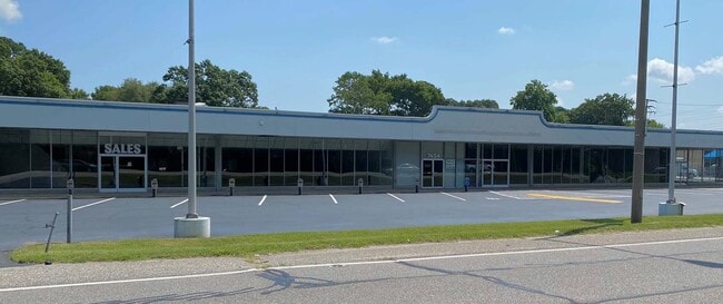
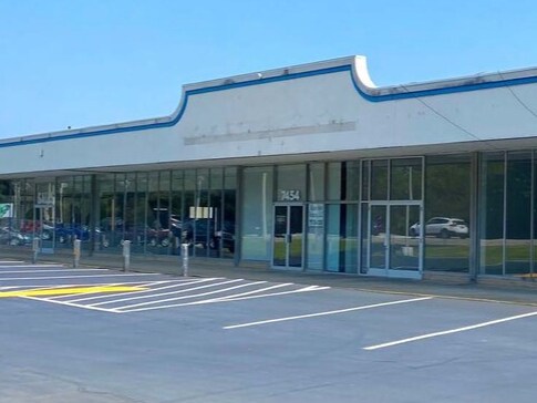
Property Record
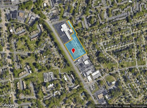
7454 N Military Hwy, Norfolk, VA 23518
NEARBY LISTINGS FOR SALE OR LEASE
Property Detail
7454 N Military Hwy
Virginia Beach-Norfolk-Newport News, VA-NC
PARCEL B
00809548
Norfolk City
Vehiclerentalsvehiclesales
Virginia
2025
5.40 AC
2025
Little Creek
006606
Hampton Roads
30,188 SF
DEMOGRAPHICS near 7454 N Military Hwy
1 Mile
3 Mile
5 Mile
2024 Total Population
16,449
103,797
236,091
2029 Population
15,922
101,119
230,955
Pop Growth 2024-2029
(3.20%)
(2.58%)
(2.18%)
Average Age
38
39
37
2024 Total Households
6,689
43,884
91,936
HH Growth 2024-2029
(3.66%)
(2.92%)
(2.55%)
Median Household Inc
$62,294
$61,662
$60,154
Avg Household Size
2.40
2.30
2.30
2024 Avg HH Vehicles
2.00
2.00
2.00
Median Home Value
$233,380
$238,146
$253,120
Median Year Built
1966
1961
1966
Nearby Places
Map Layers
Map Styles
 Street
 Aerial
- Restaurants
- Banks
- Shops
- Fitness
- Groceries
PUBLIC TRANSPORTATION
COMMUTER RAIL
Norfolk (Northeast Regional - Amtrak)
DRIVE
WALK
Distance
Norfolk (Northeast Regional - Amtrak)
12 min
6.8 mi
AIRPORT
Norfolk International
DRIVE
WALK
Distance
Norfolk International
7 min
3.0 mi
Newport News/Williamsburg International
DRIVE
WALK
Distance
Newport News/Williamsburg International
37 min
25.1 mi
Freight Ports
Virginia Port Authority - Norfolk
DRIVE
WALK
Distance
Virginia Port Authority - Norfolk
14 min
5.9 mi
SALE & LEASE HISTORY
LISTING DATE
SALE/LEASE

Oct 28, 2021
For Lease
Nearby Properties
Address
Land Use
TOTAL SIZE
Lot Size
Zoning
Address
Land Use
TOTAL SIZE
Lot Size
Zoning
116,476 SF
947.43 AC
Address
Land Use
TOTAL SIZE
Lot Size
Zoning
1,190.45 AC
Address
Land Use
TOTAL SIZE
Lot Size
Zoning
30,036 SF
50.39 AC
Address
Land Use
TOTAL SIZE
Lot Size
Zoning
8,423 SF
53.95 AC
Address
Land Use
TOTAL SIZE
Lot Size
Zoning
40.37 AC
R6
Address
Land Use
TOTAL SIZE
Lot Size
Zoning
213 AC
I5
Address
Land Use
TOTAL SIZE
Lot Size
Zoning
321,691 SF
30.58 AC
Address
Land Use
TOTAL SIZE
Lot Size
Zoning
319,444 SF
19.02 AC
O1
Address
Land Use
TOTAL SIZE
Lot Size
Zoning
167,279 SF
9.97 AC
IN1
Address
Land Use
TOTAL SIZE
Lot Size
Zoning
6,572 SF
23.41 AC
Address
Land Use
TOTAL SIZE
Lot Size
Zoning
1,020 SF
13.45 AC
R11
Address
Land Use
TOTAL SIZE
Lot Size
Zoning
19.47 AC
86
Address
Land Use
TOTAL SIZE
Lot Size
Zoning
52,612 SF
4.94 AC
Address
Land Use
TOTAL SIZE
Lot Size
Zoning
27,840 SF
5.80 AC
R11
Address
Land Use
TOTAL SIZE
Lot Size
Zoning
100,550 SF
1.72 AC
Address
Land Use
TOTAL SIZE
Lot Size
Zoning
1,980 SF
1.87 AC
Address
Land Use
TOTAL SIZE
Lot Size
Zoning
41,754 SF
6.01 AC
Address
Land Use
TOTAL SIZE
Lot Size
Zoning
170,152 SF
6.07 AC
PDMU1
Address
Land Use
TOTAL SIZE
Lot Size
Zoning
6.96 AC
R11
Address
Land Use
TOTAL SIZE
Lot Size
Zoning
25,880 SF
31.21 AC
91
Address
Land Use
TOTAL SIZE
Lot Size
Zoning
176,075 SF
7.30 AC
C2
Address
Land Use
TOTAL SIZE
Lot Size
Zoning
1.81 AC
R13
Address
Land Use
TOTAL SIZE
Lot Size
Zoning
207,440 SF
3.74 AC
R12
Address
Land Use
TOTAL SIZE
Lot Size
Zoning
40,323 SF
2.60 AC
Address
Land Use
TOTAL SIZE
Lot Size
Zoning
23.85 AC
IN1
Address
Land Use
TOTAL SIZE
Lot Size
Zoning
28,584 SF
7.76 AC
BC1
Address
Land Use
TOTAL SIZE
Lot Size
Zoning
21.89 AC
IN1
Address
Land Use
TOTAL SIZE
Lot Size
Zoning
15,898 SF
9.91 AC
IN1
Address
Land Use
TOTAL SIZE
Lot Size
Zoning
21.65 AC
Address
Land Use
TOTAL SIZE
Lot Size
Zoning
106,600 SF
2.81 AC
The World's #1 Commercial Real Estate Marketplace
Connect with us
© 2025 CoStar Group
The information above has been obtained from sources believed reliable. While we do not doubt its accuracy we have not verified it and make no guarantee, warranty or representation about it. It is your responsibility to independently confirm its accuracy and completeness. Any projections, opinions, assumptions, or estimates used are for example only and do not represent the current or future performance of the property. The value of this transaction to you depends on tax and other factors which should be evaluated by your tax, financial, and legal advisors. You and your advisors should conduct a careful, independent investigation of the property to determine to your satisfaction the suitability of the property for your needs.