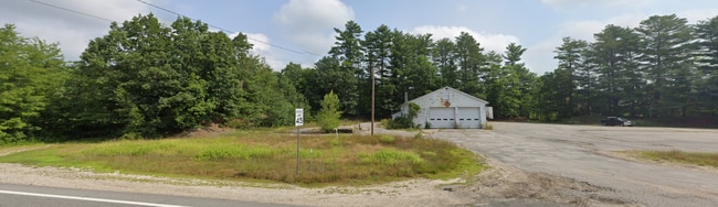
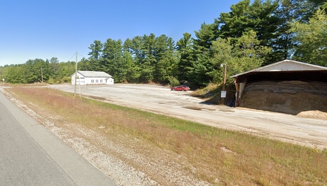
Property Record
75 Route 27, Raymond, NH 03077

Save to a Folder
{{folder.Name}}
{{folder.ListingIds.length}} Properties
{{folder.ListingIds.length}} Property
Create a New Folder
This Property Is For Sale
Property Detail
75 Route 27
RAYM-002802-000000-000012
ROCKINGHAM
Stateproperty
New Hampshire
D
12
B and X Area of moderate flood hazard, usually the area between the limits of the 100-year and 500-year floods.
3.25 AC
0
Rockingham
2025
Boston
055002
Boston-Cambridge-Newton, MA-NH
2,400 SF
NEARBY LISTINGS FOR SALE OR LEASE
DEMOGRAPHICS near 75 Route 27
1 mile
3 mile
5 mile
2025 Total Population
1,842
10,556
21,708
2030 Population
1,864
10,782
22,147
Pop Growth 2025-2030
+ 1.19%
+ 2.14%
+ 2.02%
Average Age
44
44
44
2025 Total Households
781
4,219
8,397
HH Growth 2025-2030
+ 1.15%
+ 2.01%
+ 1.91%
Median Household Inc
$72,122
$91,330
$103,122
Avg Household Size
2.30
2.50
2.50
2025 Avg HH Vehicles
2.00
2.00
2.00
Median Home Value
$325,694
$385,766
$426,024
Median Year Built
1977
1986
1986
Nearby Places
Map Layers
Map Styles
 Street
 Aerial
Layers
 Traffic
 Biking
Places
Listings with unknown addresses are not visible on the map
- Restaurants
- Banks
- Shops
- Fitness
- Groceries
PUBLIC TRANSPORTATION
AIRPORT
Manchester Boston Regional
Drive
Walk
Distance
Manchester Boston Regional
35 min
23.0 mi
Portsmouth International at Pease
Drive
Walk
Distance
Portsmouth International at Pease
42 min
25.9 mi
Freight Ports
Port of Boston
Drive
Walk
Distance
Port of Boston
90 min
56.9 mi
Nearby Properties
Address
Land Use
TOTAL SIZE
Lot Size
Zoning
Address
Land Use
TOTAL SIZE
Lot Size
Zoning
220 AC
D
Address
Land Use
TOTAL SIZE
Lot Size
Zoning
2,295.68 AC
R-AG R
Address
Land Use
TOTAL SIZE
Lot Size
Zoning
134,598 SF
66.30 AC
B
Address
Land Use
TOTAL SIZE
Lot Size
Zoning
103,712 SF
28.60 AC
Address
Land Use
TOTAL SIZE
Lot Size
Zoning
50,367 SF
13.65 AC
C1
Address
Land Use
TOTAL SIZE
Lot Size
Zoning
25,740 SF
24 AC
C2
Address
Land Use
TOTAL SIZE
Lot Size
Zoning
38,881 SF
22.50 AC
D
Address
Land Use
TOTAL SIZE
Lot Size
Zoning
6,608 SF
95.06 AC
C2
Address
Land Use
TOTAL SIZE
Lot Size
Zoning
1,120 SF
46.74 AC
RR
Address
Land Use
TOTAL SIZE
Lot Size
Zoning
79,093 SF
8.95 AC
C1
Address
Land Use
TOTAL SIZE
Lot Size
Zoning
54,154 SF
14 AC
A
Address
Land Use
TOTAL SIZE
Lot Size
Zoning
6,600 SF
39.11 AC
C1
Address
Land Use
TOTAL SIZE
Lot Size
Zoning
12,974 SF
8.50 AC
C1
Address
Land Use
TOTAL SIZE
Lot Size
Zoning
936 SF
89 AC
C1
Address
Land Use
TOTAL SIZE
Lot Size
Zoning
3.43 AC
C1
Address
Land Use
TOTAL SIZE
Lot Size
Zoning
1,680 SF
4.98 AC
C1
Address
Land Use
TOTAL SIZE
Lot Size
Zoning
360 SF
50.44 AC
Address
Land Use
TOTAL SIZE
Lot Size
Zoning
19,388 SF
1.83 AC
C1
Address
Land Use
TOTAL SIZE
Lot Size
Zoning
8.62 AC
C1
Address
Land Use
TOTAL SIZE
Lot Size
Zoning
18,036 SF
6.70 AC
A
Address
Land Use
TOTAL SIZE
Lot Size
Zoning
10,069 SF
4.50 AC
C1
Address
Land Use
TOTAL SIZE
Lot Size
Zoning
54,840 SF
11.16 AC
D
Address
Land Use
TOTAL SIZE
Lot Size
Zoning
50,160 SF
4.04 AC
D
Address
Land Use
TOTAL SIZE
Lot Size
Zoning
3,120 SF
6 AC
B
Address
Land Use
TOTAL SIZE
Lot Size
Zoning
1,920 SF
9.34 AC
C1
Address
Land Use
TOTAL SIZE
Lot Size
Zoning
11.46 AC
Address
Land Use
TOTAL SIZE
Lot Size
Zoning
123.52 AC
D
Address
Land Use
TOTAL SIZE
Lot Size
Zoning
2,808 SF
532.10 AC
D
Address
Land Use
TOTAL SIZE
Lot Size
Zoning
14,478 SF
1.61 AC
C1
Address
Land Use
TOTAL SIZE
Lot Size
Zoning
4,000 SF
19.39 AC
C1
The World's #1 Commercial Real Estate Marketplace
Connect with us
© 2026 CoStar Group
The information above has been obtained from sources believed reliable. While we do not doubt its accuracy we have not verified it and make no guarantee, warranty or representation about it. It is your responsibility to independently confirm its accuracy and completeness. Any projections, opinions, assumptions, or estimates used are for example only and do not represent the current or future performance of the property. The value of this transaction to you depends on tax and other factors which should be evaluated by your tax, financial, and legal advisors. You and your advisors should conduct a careful, independent investigation of the property to determine to your satisfaction the suitability of the property for your needs.