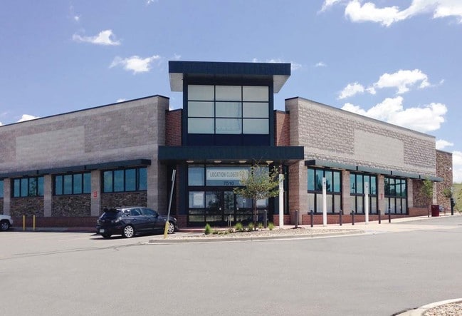
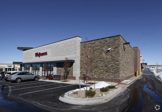
Property Record
7510 S Gartrell Rd, Aurora, CO 80016

Property Detail
7510 S Gartrell Rd
2073-36-1-10-004
SUBDIVISIONCD 054006 SUBDIVISIONNAME SADDLE ROCK EAST COMMERCIAL SUB 1ST FLG BLOCK 001 LOT 001 LOT 1 BLK 1 SADDLE ROCK EAST COMMERCIAL SUB 1ST FLG EX THAT PART DESC AS BEG AT THE SE COR OF SD LOT TH SW 224.24 FT TH NW 75.65 FT TH NE 234.2 FT TH SE 75
Storebuilding
Arapahoe
RPD
Colorado
B and X Area of moderate flood hazard, usually the area between the limits of the 100-year and 500-year floods.
1
2024
1.12 AC
2025
Southeast
086500
Denver
15,156 SF
Denver-Aurora-Centennial, CO
NEARBY LISTINGS FOR SALE OR LEASE
DEMOGRAPHICS near 7510 S Gartrell Rd
1 mile
3 mile
5 mile
2025 Total Population
10,569
68,085
177,862
2030 Population
10,697
70,009
183,508
Pop Growth 2025-2030
+ 1.21%
+ 2.83%
+ 3.17%
Average Age
46
40
38
2025 Total Households
4,403
23,403
61,294
HH Growth 2025-2030
+ 1.20%
+ 2.99%
+ 3.49%
Median Household Inc
$120,401
$147,020
$133,131
Avg Household Size
2.40
2.90
2.90
2025 Avg HH Vehicles
2.00
2.00
2.00
Median Home Value
$722,330
$753,283
$699,933
Median Year Built
2005
2005
2002
Nearby Places
Map Layers
Map Styles
 Street
 Aerial
Transit
 Traffic
 Biking
Places
Listings with unknown addresses are not visible on the map
- Restaurants
- Banks
- Shops
- Fitness
- Groceries
PUBLIC TRANSPORTATION
AIRPORT
Denver International
Drive
Walk
Distance
Denver International
28 min
24.5 mi
SALE & LEASE HISTORY
LISTING DATE
SALE/LEASE

Mar 09, 2017
For Lease
Nearby Properties
Address
Land Use
TOTAL SIZE
Lot Size
Zoning
Address
Land Use
TOTAL SIZE
Lot Size
Zoning
355,644 SF
123.82 AC
Address
Land Use
TOTAL SIZE
Lot Size
Zoning
502,000 SF
22.32 AC
RPD
Address
Land Use
TOTAL SIZE
Lot Size
Zoning
346,890 SF
38.99 AC
AA1
Address
Land Use
TOTAL SIZE
Lot Size
Zoning
448,149 SF
33.62 AC
RE470
Address
Land Use
TOTAL SIZE
Lot Size
Zoning
137,372 SF
5.86 AC
Address
Land Use
TOTAL SIZE
Lot Size
Zoning
129,701 SF
6.56 AC
Address
Land Use
TOTAL SIZE
Lot Size
Zoning
359,400 SF
20.36 AC
Address
Land Use
TOTAL SIZE
Lot Size
Zoning
5,380 SF
20.48 AC
RE470
Address
Land Use
TOTAL SIZE
Lot Size
Zoning
489,120 SF
20.10 AC
RE470
Address
Land Use
TOTAL SIZE
Lot Size
Zoning
445,938 SF
19.85 AC
Address
Land Use
TOTAL SIZE
Lot Size
Zoning
319,078 SF
18.49 AC
RE470
Address
Land Use
TOTAL SIZE
Lot Size
Zoning
40,249 SF
13.44 AC
Address
Land Use
TOTAL SIZE
Lot Size
Zoning
151,246 SF
13.25 AC
RE470
Address
Land Use
TOTAL SIZE
Lot Size
Zoning
389,337 SF
22.01 AC
Address
Land Use
TOTAL SIZE
Lot Size
Zoning
308,396 SF
19.45 AC
RPCZD
Address
Land Use
TOTAL SIZE
Lot Size
Zoning
379,109 SF
16.45 AC
Address
Land Use
TOTAL SIZE
Lot Size
Zoning
298,589 SF
14.52 AC
RPCZD
Address
Land Use
TOTAL SIZE
Lot Size
Zoning
65,120 SF
11.17 AC
Address
Land Use
TOTAL SIZE
Lot Size
Zoning
40,935 SF
3.38 AC
RE470
Address
Land Use
TOTAL SIZE
Lot Size
Zoning
206,122 SF
24.97 AC
Address
Land Use
TOTAL SIZE
Lot Size
Zoning
53,736 SF
17.28 AC
RPD
Address
Land Use
TOTAL SIZE
Lot Size
Zoning
121,777 SF
10.94 AC
RE470
Address
Land Use
TOTAL SIZE
Lot Size
Zoning
91,380 SF
5.52 AC
Address
Land Use
TOTAL SIZE
Lot Size
Zoning
69,543 SF
9.95 AC
Address
Land Use
TOTAL SIZE
Lot Size
Zoning
140,000 SF
24.16 AC
AMU
Address
Land Use
TOTAL SIZE
Lot Size
Zoning
174,444 SF
15.64 AC
RPD
Address
Land Use
TOTAL SIZE
Lot Size
Zoning
32,811 SF
6.48 AC
Address
Land Use
TOTAL SIZE
Lot Size
Zoning
148,579 SF
10.31 AC
PUD
Address
Land Use
TOTAL SIZE
Lot Size
Zoning
55,800 SF
12.80 AC
Address
Land Use
TOTAL SIZE
Lot Size
Zoning
14,066 SF
13.98 AC
AMU
The World's #1 Commercial Real Estate Marketplace
Connect with us
© 2026 CoStar Group
The information above has been obtained from sources believed reliable. While we do not doubt its accuracy we have not verified it and make no guarantee, warranty or representation about it. It is your responsibility to independently confirm its accuracy and completeness. Any projections, opinions, assumptions, or estimates used are for example only and do not represent the current or future performance of the property. The value of this transaction to you depends on tax and other factors which should be evaluated by your tax, financial, and legal advisors. You and your advisors should conduct a careful, independent investigation of the property to determine to your satisfaction the suitability of the property for your needs.