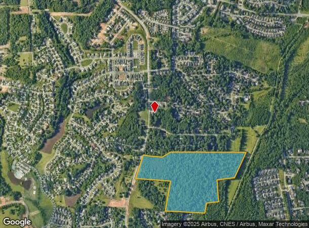
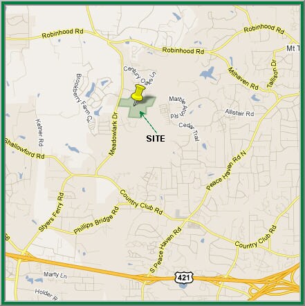
Property Record
755 Meadowlark Dr, Winston Salem, NC 27106

NEARBY LISTINGS FOR SALE OR LEASE
Property Detail
755 Meadowlark Dr
Winston-Salem, NC
LO:014D BL:4620
5896-70-9994
Forsyth
Residentialacreage
North Carolina
X
14d
3710589600J
59.12 AC
2024
Western Forsyth County
2025
Greensboro/Winston-Salem
004010
DEMOGRAPHICS near 755 Meadowlark Dr
1 Mile
3 Mile
5 Mile
2024 Total Population
5,165
45,403
110,695
2029 Population
5,503
47,203
115,038
Pop Growth 2024-2029
+ 6.54%
+ 3.96%
+ 3.92%
Average Age
40
41
41
2024 Total Households
2,059
19,394
47,067
HH Growth 2024-2029
+ 6.70%
+ 3.94%
+ 3.94%
Median Household Inc
$131,994
$85,154
$78,366
Avg Household Size
2.50
2.30
2.30
2024 Avg HH Vehicles
2.00
2.00
2.00
Median Home Value
$401,569
$313,585
$280,126
Median Year Built
1999
1986
1983
Nearby Places
Map Layers
Map Styles
 Street
 Aerial
- Restaurants
- Banks
- Shops
- Fitness
- Groceries
PUBLIC TRANSPORTATION
AIRPORT
Piedmont Triad International
DRIVE
WALK
Distance
Piedmont Triad International
46 min
30.6 mi
Freight Ports
Virginia Port Authority - Richmond
DRIVE
WALK
Distance
Virginia Port Authority - Richmond
273 min
234.2 mi
SALE & LEASE HISTORY
LISTING DATE
SALE/LEASE

Mar 01, 2017
For Sale
Nearby Properties
Address
Land Use
TOTAL SIZE
Lot Size
Zoning
Address
Land Use
TOTAL SIZE
Lot Size
Zoning
124,972 SF
19.32 AC
MU-S
Address
Land Use
TOTAL SIZE
Lot Size
Zoning
128,592 SF
28.33 AC
GB-S
Address
Land Use
TOTAL SIZE
Lot Size
Zoning
95,995 SF
31.49 AC
RM12,RM18
Address
Land Use
TOTAL SIZE
Lot Size
Zoning
61,125 SF
8.66 AC
MU-S
Address
Land Use
TOTAL SIZE
Lot Size
Zoning
125,015 SF
33.69 AC
LO-S,RM8-S
Address
Land Use
TOTAL SIZE
Lot Size
Zoning
275,051 SF
32.47 AC
PB-S,RM18
Address
Land Use
TOTAL SIZE
Lot Size
Zoning
189,737 SF
20.53 AC
CD1-S
Address
Land Use
TOTAL SIZE
Lot Size
Zoning
139,775 SF
11.57 AC
HB,RS9
Address
Land Use
TOTAL SIZE
Lot Size
Zoning
115,352 SF
11.21 AC
RM8-S
Address
Land Use
TOTAL SIZE
Lot Size
Zoning
68,118 SF
12.74 AC
MU-S
Address
Land Use
TOTAL SIZE
Lot Size
Zoning
179,142 SF
42.52 AC
RS9
Address
Land Use
TOTAL SIZE
Lot Size
Zoning
120,118 SF
15.71 AC
RM18
Address
Land Use
TOTAL SIZE
Lot Size
Zoning
141,377 SF
37.07 AC
IP
Address
Land Use
TOTAL SIZE
Lot Size
Zoning
402,885 SF
19.63 AC
HB-S
Address
Land Use
TOTAL SIZE
Lot Size
Zoning
73,930 SF
18 AC
RM12-S
Address
Land Use
TOTAL SIZE
Lot Size
Zoning
113,351 SF
11.87 AC
MU-S
Address
Land Use
TOTAL SIZE
Lot Size
Zoning
64,236 SF
14.71 AC
RM12-S
Address
Land Use
TOTAL SIZE
Lot Size
Zoning
62,546 SF
4.63 AC
LO-S
Address
Land Use
TOTAL SIZE
Lot Size
Zoning
80,319 SF
14.77 AC
RM12,RM18-
Address
Land Use
TOTAL SIZE
Lot Size
Zoning
68,153 SF
8.60 AC
GB-S
Address
Land Use
TOTAL SIZE
Lot Size
Zoning
56,638 SF
16.54 AC
RM8-S
Address
Land Use
TOTAL SIZE
Lot Size
Zoning
89,801 SF
9.50 AC
PB-S
Address
Land Use
TOTAL SIZE
Lot Size
Zoning
75,507 SF
12.46 AC
RM18
Address
Land Use
TOTAL SIZE
Lot Size
Zoning
90,769 SF
11.09 AC
RM18
Address
Land Use
TOTAL SIZE
Lot Size
Zoning
82,432 SF
11.28 AC
HB-S
Address
Land Use
TOTAL SIZE
Lot Size
Zoning
45,427 SF
17.84 AC
RM8-S
Address
Land Use
TOTAL SIZE
Lot Size
Zoning
79,327 SF
22.97 AC
RS9
Address
Land Use
TOTAL SIZE
Lot Size
Zoning
74,416 SF
9.47 AC
RM8-S
Address
Land Use
TOTAL SIZE
Lot Size
Zoning
62,100 SF
2.64 AC
GB-S
Address
Land Use
TOTAL SIZE
Lot Size
Zoning
80,418 SF
21.94 AC
IP
The World's #1 Commercial Real Estate Marketplace
Connect with us
© 2026 CoStar Group
The information above has been obtained from sources believed reliable. While we do not doubt its accuracy we have not verified it and make no guarantee, warranty or representation about it. It is your responsibility to independently confirm its accuracy and completeness. Any projections, opinions, assumptions, or estimates used are for example only and do not represent the current or future performance of the property. The value of this transaction to you depends on tax and other factors which should be evaluated by your tax, financial, and legal advisors. You and your advisors should conduct a careful, independent investigation of the property to determine to your satisfaction the suitability of the property for your needs.