Property Record
760 E Brier Dr, San Bernardino, CA 92408


Save to a Folder
{{folder.Name}}
{{folder.ListingIds.length}} Properties
{{folder.ListingIds.length}} Property
Create a New Folder
Property Detail
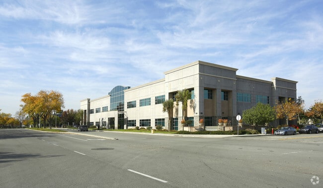
760 E Brier Dr
0281-301-25
PARCEL MAP 5464 PARCEL NO 10, 11 AND PTN PARCEL 1 DESC AS FOL BEG SW COR SD PARCEL 11 TH N 0 DEG 28 MIN 24 SECONDS W 432.99 FT TH N 89 DEG 47 MIN 57 SECONDS E 318.27 FT TH S 65 DEG 12 MIN 03 SECONDS E 27.68 FT TO PT ON NON-TANGENT CURVE CONCAVE TO SE
Officebuilding
San Bernardino
B and X Area of moderate flood hazard, usually the area between the limits of the 100-year and 500-year floods.
California
0
3.45 AC
2026
San Bernardino
007202
Inland Empire (California)
51,078 SF
Riverside-San Bernardino-Ontario, CA
NEARBY LISTINGS FOR SALE OR LEASE
DEMOGRAPHICS near 760 E Brier Dr
1 mile
3 mile
5 mile
2025 Total Population
3,554
77,268
283,321
2030 Population
3,623
78,451
287,804
Pop Growth 2025-2030
+ 1.94%
+ 1.53%
+ 1.58%
Average Age
36
36
35
2025 Total Households
1,007
25,389
86,412
HH Growth 2025-2030
+ 2.09%
+ 1.74%
+ 1.69%
Median Household Inc
$71,590
$70,316
$67,883
Avg Household Size
3.30
2.90
3.20
2025 Avg HH Vehicles
2.00
2.00
2.00
Median Home Value
$482,098
$466,912
$437,429
Median Year Built
1971
1979
1974
Nearby Places
Map Layers
Map Styles
 Street
 Aerial
Layers
 Traffic
 Biking
Places
Listings with unknown addresses are not visible on the map
- Restaurants
- Banks
- Shops
- Fitness
- Groceries
PUBLIC TRANSPORTATION
COMMUTER RAIL
Drive
Walk
Distance
3 min
13 min
0.7 mi
Drive
Walk
Distance
9 min
4.1 mi
AIRPORT
Ontario International
Drive
Walk
Distance
Ontario International
29 min
21.0 mi
Nearby Properties
Address
Land Use
TOTAL SIZE
Lot Size
Zoning
Address
Land Use
TOTAL SIZE
Lot Size
Zoning
1,831,174 SF
20.38 AC
Address
Land Use
TOTAL SIZE
Lot Size
Zoning
2,134,798 SF
153.92 AC
Address
Land Use
TOTAL SIZE
Lot Size
Zoning
345,158 SF
36.95 AC
Address
Land Use
TOTAL SIZE
Lot Size
Zoning
457,253 SF
20.14 AC
Address
Land Use
TOTAL SIZE
Lot Size
Zoning
308,030 SF
16.20 AC
Address
Land Use
TOTAL SIZE
Lot Size
Zoning
589,602 SF
36.89 AC
Address
Land Use
TOTAL SIZE
Lot Size
Zoning
1,313,470 SF
60.31 AC
Address
Land Use
TOTAL SIZE
Lot Size
Zoning
1,012,980 SF
50.48 AC
Address
Land Use
TOTAL SIZE
Lot Size
Zoning
1,032,072 SF
61.74 AC
Address
Land Use
TOTAL SIZE
Lot Size
Zoning
497,664 SF
56.39 AC
Address
Land Use
TOTAL SIZE
Lot Size
Zoning
356,421 SF
16.03 AC
Address
Land Use
TOTAL SIZE
Lot Size
Zoning
1,081,199 SF
49.77 AC
Address
Land Use
TOTAL SIZE
Lot Size
Zoning
417,188 SF
21.54 AC
Address
Land Use
TOTAL SIZE
Lot Size
Zoning
300,188 SF
11.98 AC
Address
Land Use
TOTAL SIZE
Lot Size
Zoning
1,139,976 SF
49.56 AC
Address
Land Use
TOTAL SIZE
Lot Size
Zoning
771,907 SF
35.59 AC
Address
Land Use
TOTAL SIZE
Lot Size
Zoning
345,237 SF
14.52 AC
Address
Land Use
TOTAL SIZE
Lot Size
Zoning
784,280 SF
34.62 AC
EVSDCOM
Address
Land Use
TOTAL SIZE
Lot Size
Zoning
758,180 SF
31.86 AC
Address
Land Use
TOTAL SIZE
Lot Size
Zoning
330,420 SF
15.31 AC
Address
Land Use
TOTAL SIZE
Lot Size
Zoning
286,813 SF
9.50 AC
EVSDCOM
Address
Land Use
TOTAL SIZE
Lot Size
Zoning
983,986 SF
47.60 AC
Address
Land Use
TOTAL SIZE
Lot Size
Zoning
391,468 SF
16.73 AC
Address
Land Use
TOTAL SIZE
Lot Size
Zoning
809,679 SF
37.19 AC
Address
Land Use
TOTAL SIZE
Lot Size
Zoning
1,205,400 SF
58.05 AC
Address
Land Use
TOTAL SIZE
Lot Size
Zoning
210,418 SF
12.09 AC
Address
Land Use
TOTAL SIZE
Lot Size
Zoning
951,686 SF
47.90 AC
Address
Land Use
TOTAL SIZE
Lot Size
Zoning
913,716 SF
20 AC
Address
Land Use
TOTAL SIZE
Lot Size
Zoning
225,324 SF
11.03 AC
Address
Land Use
TOTAL SIZE
Lot Size
Zoning
474,680 SF
17.95 AC
The World's #1 Commercial Real Estate Marketplace
Connect with us
© 2026 CoStar Group
The information above has been obtained from sources believed reliable. While we do not doubt its accuracy we have not verified it and make no guarantee, warranty or representation about it. It is your responsibility to independently confirm its accuracy and completeness. Any projections, opinions, assumptions, or estimates used are for example only and do not represent the current or future performance of the property. The value of this transaction to you depends on tax and other factors which should be evaluated by your tax, financial, and legal advisors. You and your advisors should conduct a careful, independent investigation of the property to determine to your satisfaction the suitability of the property for your needs.