Property Record
7603 Bluff Point Dr, Houston, TX 77086
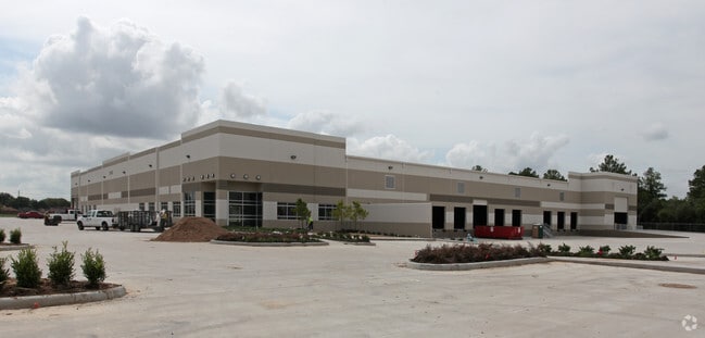

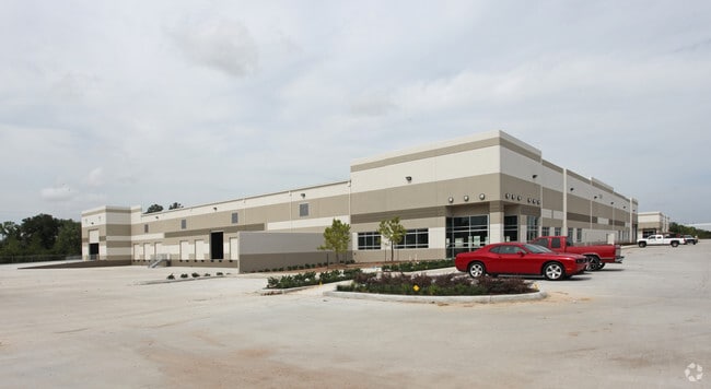
Property Detail
7603 Bluff Point Dr
1162670010001
RES C BLK 1 NORTHWEST GREEN BUSINESS PK SEC 1 PAR R/P
Warehouse
HARRIS
B and X Area of moderate flood hazard, usually the area between the limits of the 100-year and 500-year floods.
Texas
2024
11.97 AC
2025
North Fwy/Tomball Pky
533902
Houston
209,825 SF
Houston-Pasadena-The Woodlands, TX
NEARBY LISTINGS FOR SALE OR LEASE
DEMOGRAPHICS near 7603 Bluff Point Dr
1 mile
3 mile
5 mile
2025 Total Population
17,564
100,183
327,471
2030 Population
18,279
105,708
346,508
Pop Growth 2025-2030
+ 4.07%
+ 5.51%
+ 5.81%
Average Age
36
36
37
2025 Total Households
5,333
29,379
108,390
HH Growth 2025-2030
+ 4.09%
+ 5.69%
+ 6.05%
Median Household Inc
$55,268
$70,666
$64,447
Avg Household Size
3.30
3.30
3.00
2025 Avg HH Vehicles
2.00
2.00
2.00
Median Home Value
$218,848
$225,058
$241,783
Median Year Built
1986
1987
1988
Nearby Places
Map Layers
Map Styles
 Street
 Aerial
Layers
 Traffic
 Biking
Places
Listings with unknown addresses are not visible on the map
- Restaurants
- Banks
- Shops
- Fitness
- Groceries
PUBLIC TRANSPORTATION
AIRPORT
George Bush Intcntl/Houston
Drive
Walk
Distance
George Bush Intcntl/Houston
18 min
13.4 mi
William P Hobby
Drive
Walk
Distance
William P Hobby
46 min
28.7 mi
Freight Ports
Port of Houston
Drive
Walk
Distance
Port of Houston
38 min
24.3 mi
Nearby Properties
Address
Land Use
TOTAL SIZE
Lot Size
Zoning
Address
Land Use
TOTAL SIZE
Lot Size
Zoning
778,140 SF
40.25 AC
Address
Land Use
TOTAL SIZE
Lot Size
Zoning
552,757 SF
32.95 AC
Address
Land Use
TOTAL SIZE
Lot Size
Zoning
546,420 SF
40.07 AC
Address
Land Use
TOTAL SIZE
Lot Size
Zoning
527,744 SF
35.46 AC
Address
Land Use
TOTAL SIZE
Lot Size
Zoning
397,248 SF
26.37 AC
Address
Land Use
TOTAL SIZE
Lot Size
Zoning
365,380 SF
19.17 AC
Address
Land Use
TOTAL SIZE
Lot Size
Zoning
495,024 SF
23.96 AC
Address
Land Use
TOTAL SIZE
Lot Size
Zoning
502,860 SF
40.99 AC
Address
Land Use
TOTAL SIZE
Lot Size
Zoning
602,940 SF
30.90 AC
Address
Land Use
TOTAL SIZE
Lot Size
Zoning
399,828 SF
20.32 AC
Address
Land Use
TOTAL SIZE
Lot Size
Zoning
424,122 SF
21.06 AC
Address
Land Use
TOTAL SIZE
Lot Size
Zoning
339,301 SF
68.40 AC
Address
Land Use
TOTAL SIZE
Lot Size
Zoning
361,800 SF
18.20 AC
Address
Land Use
TOTAL SIZE
Lot Size
Zoning
441,000 SF
23.07 AC
Address
Land Use
TOTAL SIZE
Lot Size
Zoning
351,235 SF
20.73 AC
Address
Land Use
TOTAL SIZE
Lot Size
Zoning
215,968 SF
17.23 AC
Address
Land Use
TOTAL SIZE
Lot Size
Zoning
356,656 SF
23.54 AC
Address
Land Use
TOTAL SIZE
Lot Size
Zoning
299,280 SF
15.71 AC
Address
Land Use
TOTAL SIZE
Lot Size
Zoning
292,112 SF
4.41 AC
Address
Land Use
TOTAL SIZE
Lot Size
Zoning
272,600 SF
23.27 AC
Address
Land Use
TOTAL SIZE
Lot Size
Zoning
200,123 SF
14.94 AC
Address
Land Use
TOTAL SIZE
Lot Size
Zoning
293,280 SF
16.24 AC
Address
Land Use
TOTAL SIZE
Lot Size
Zoning
614,712 SF
7.93 AC
Address
Land Use
TOTAL SIZE
Lot Size
Zoning
352,680 SF
28.21 AC
Address
Land Use
TOTAL SIZE
Lot Size
Zoning
240,905 SF
19.98 AC
Address
Land Use
TOTAL SIZE
Lot Size
Zoning
287,510 SF
19.43 AC
Address
Land Use
TOTAL SIZE
Lot Size
Zoning
241,946 SF
14.02 AC
Address
Land Use
TOTAL SIZE
Lot Size
Zoning
220,000 SF
12.07 AC
Address
Land Use
TOTAL SIZE
Lot Size
Zoning
253,369 SF
16.81 AC
Address
Land Use
TOTAL SIZE
Lot Size
Zoning
211,036 SF
11.62 AC
The World's #1 Commercial Real Estate Marketplace
Connect with us
© 2026 CoStar Group
The information above has been obtained from sources believed reliable. While we do not doubt its accuracy we have not verified it and make no guarantee, warranty or representation about it. It is your responsibility to independently confirm its accuracy and completeness. Any projections, opinions, assumptions, or estimates used are for example only and do not represent the current or future performance of the property. The value of this transaction to you depends on tax and other factors which should be evaluated by your tax, financial, and legal advisors. You and your advisors should conduct a careful, independent investigation of the property to determine to your satisfaction the suitability of the property for your needs.