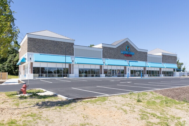
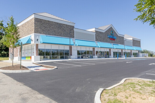
Property Record
765 State Route 10, Randolph, NJ 07869

Current Lease Availabilities
Property Detail
765 State Route 10
Newark, NJ
INCL BLK 44 LOTS 14 & 14-02
32-00044-0000-00014
Morris
Commercialnec
New Jersey
B-2
14
2024
5.90 AC
2025
Western Morris
046500
Northern New Jersey
5,995 SF
NEARBY LISTINGS FOR SALE OR LEASE
DEMOGRAPHICS near 765 State Route 10
1 mile
3 mile
5 mile
2025 Total Population
4,568
52,292
114,882
2030 Population
4,616
53,476
117,595
Pop Growth 2025-2030
+ 1.05%
+ 2.26%
+ 2.36%
Average Age
42
41
42
2025 Total Households
1,609
18,068
41,368
HH Growth 2025-2030
+ 0.99%
+ 2.40%
+ 2.50%
Median Household Inc
$175,662
$106,457
$124,772
Avg Household Size
2.80
2.80
2.70
2025 Avg HH Vehicles
2.00
2.00
2.00
Median Home Value
$567,471
$473,875
$494,202
Median Year Built
1983
1969
1974
Nearby Places
Map Layers
Map Styles
 Street
 Aerial
Transit
 Traffic
 Biking
Places
Listings with unknown addresses are not visible on the map
- Restaurants
- Banks
- Shops
- Fitness
- Groceries
PUBLIC TRANSPORTATION
COMMUTER RAIL
Dover (Montclair-Boonton Line - NJ Transit Commuter Rail (NJ Transit), Morris & Essex Morristown Line - NJ Transit Commuter Rail (NJ Transit))
Drive
Walk
Distance
Dover (Montclair-Boonton Line - NJ Transit Commuter Rail (NJ Transit), Morris & Essex Morristown Line - NJ Transit Commuter Rail (NJ Transit))
6 min
3.1 mi
Mount Arlington (Montclair-Boonton Line - NJ Transit Commuter Rail (NJ Transit), Morris & Essex Morristown Line - NJ Transit Commuter Rail (NJ Transit))
Drive
Walk
Distance
Mount Arlington (Montclair-Boonton Line - NJ Transit Commuter Rail (NJ Transit), Morris & Essex Morristown Line - NJ Transit Commuter Rail (NJ Transit))
10 min
5.9 mi
AIRPORT
Newark Liberty International
Drive
Walk
Distance
Newark Liberty International
40 min
31.4 mi
Freight Ports
Maher Terminal
Drive
Walk
Distance
Maher Terminal
44 min
32.0 mi
Nearby Properties
Address
Land Use
TOTAL SIZE
Lot Size
Zoning
Address
Land Use
TOTAL SIZE
Lot Size
Zoning
222.79 AC
R1
Address
Land Use
TOTAL SIZE
Lot Size
Zoning
64.62 AC
R3
Address
Land Use
TOTAL SIZE
Lot Size
Zoning
30.13 AC
I-3
Address
Land Use
TOTAL SIZE
Lot Size
Zoning
28.62 AC
OSGU
Address
Land Use
TOTAL SIZE
Lot Size
Zoning
197,412 SF
28.60 AC
OSGU
Address
Land Use
TOTAL SIZE
Lot Size
Zoning
20.05 AC
R-1
Address
Land Use
TOTAL SIZE
Lot Size
Zoning
Address
Land Use
TOTAL SIZE
Lot Size
Zoning
276,378 SF
40.50 AC
OSGU
Address
Land Use
TOTAL SIZE
Lot Size
Zoning
8.19 AC
B-3
Address
Land Use
TOTAL SIZE
Lot Size
Zoning
440.89 AC
POLI
Address
Land Use
TOTAL SIZE
Lot Size
Zoning
Address
Land Use
TOTAL SIZE
Lot Size
Zoning
19.47 AC
R-4
Address
Land Use
TOTAL SIZE
Lot Size
Zoning
13.53 AC
R10
Address
Land Use
TOTAL SIZE
Lot Size
Zoning
457,072 SF
64.13 AC
I-1
Address
Land Use
TOTAL SIZE
Lot Size
Zoning
199,694 SF
29.23 AC
B-3
Address
Land Use
TOTAL SIZE
Lot Size
Zoning
16.21 AC
R-4
Address
Land Use
TOTAL SIZE
Lot Size
Zoning
42.43 AC
R-5
Address
Land Use
TOTAL SIZE
Lot Size
Zoning
79,962 SF
27.80 AC
GU
Address
Land Use
TOTAL SIZE
Lot Size
Zoning
22,289 SF
5 AC
R1
Address
Land Use
TOTAL SIZE
Lot Size
Zoning
9.81 AC
B2
Address
Land Use
TOTAL SIZE
Lot Size
Zoning
4,200 SF
34.12 AC
GU
Address
Land Use
TOTAL SIZE
Lot Size
Zoning
12.61 AC
R-4
Address
Land Use
TOTAL SIZE
Lot Size
Zoning
68,830 SF
22 AC
OSGU
Address
Land Use
TOTAL SIZE
Lot Size
Zoning
7.79 AC
B-4
Address
Land Use
TOTAL SIZE
Lot Size
Zoning
3.50 AC
B-2
Address
Land Use
TOTAL SIZE
Lot Size
Zoning
20.16 AC
I-1
Address
Land Use
TOTAL SIZE
Lot Size
Zoning
38,526 SF
10 AC
R2
Address
Land Use
TOTAL SIZE
Lot Size
Zoning
Address
Land Use
TOTAL SIZE
Lot Size
Zoning
65,128 SF
1.69 AC
B-2
Address
Land Use
TOTAL SIZE
Lot Size
Zoning
70,228 SF
16.24 AC
R3
The World's #1 Commercial Real Estate Marketplace
Connect with us
© 2026 CoStar Group
The information above has been obtained from sources believed reliable. While we do not doubt its accuracy we have not verified it and make no guarantee, warranty or representation about it. It is your responsibility to independently confirm its accuracy and completeness. Any projections, opinions, assumptions, or estimates used are for example only and do not represent the current or future performance of the property. The value of this transaction to you depends on tax and other factors which should be evaluated by your tax, financial, and legal advisors. You and your advisors should conduct a careful, independent investigation of the property to determine to your satisfaction the suitability of the property for your needs.