Property Record
7665 S Research Dr, Tempe, AZ 85284
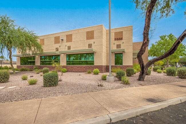


This Property Is For Sale
Property Detail
7665 S Research Dr
301-53-306
ASU RESEARCH PARK AMD MCR 1219-28
Stateproperty
Maricopa
AG
Arizona
C and X Area of minimal flood hazard, usually depicted on FIRMs as above the 500-year flood level.
2
0
1.90 AC
2025
South Tempe/Ahwatukee
319909
Phoenix
9,969 SF
Phoenix-Mesa-Chandler, AZ
NEARBY LISTINGS FOR SALE OR LEASE
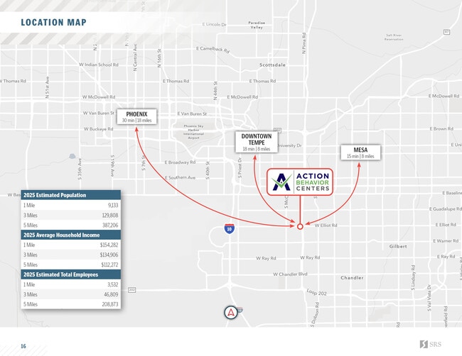
DEMOGRAPHICS near 7665 S Research Dr
1 mile
3 mile
5 mile
2025 Total Population
9,328
128,977
381,595
2030 Population
9,615
132,440
393,142
Pop Growth 2025-2030
+ 3.08%
+ 2.68%
+ 3.03%
Average Age
43
40
37
2025 Total Households
3,791
51,456
154,157
HH Growth 2025-2030
+ 3.19%
+ 2.72%
+ 3.13%
Median Household Inc
$115,581
$106,305
$84,250
Avg Household Size
2.40
2.40
2.40
2025 Avg HH Vehicles
2.00
2.00
2.00
Median Home Value
$543,986
$475,087
$459,503
Median Year Built
1984
1983
1985
Nearby Places
Map Layers
Map Styles
 Street
 Aerial
Layers
 Traffic
 Biking
Places
Listings with unknown addresses are not visible on the map
- Restaurants
- Banks
- Shops
- Fitness
- Groceries
PUBLIC TRANSPORTATION
AIRPORT
Phoenix Sky Harbor International
Drive
Walk
Distance
Phoenix Sky Harbor International
20 min
13.2 mi
Phoenix-Mesa Gateway
Drive
Walk
Distance
Phoenix-Mesa Gateway
27 min
18.6 mi
Nearby Properties
Address
Land Use
TOTAL SIZE
Lot Size
Zoning
Address
Land Use
TOTAL SIZE
Lot Size
Zoning
136,458 SF
7.85 AC
PAD
Address
Land Use
TOTAL SIZE
Lot Size
Zoning
128,194 SF
8.58 AC
PAD
Address
Land Use
TOTAL SIZE
Lot Size
Zoning
1,418,890 SF
39 AC
PF
Address
Land Use
TOTAL SIZE
Lot Size
Zoning
860,343 SF
56.83 AC
I-1
Address
Land Use
TOTAL SIZE
Lot Size
Zoning
984,487 SF
37.54 AC
I-1
Address
Land Use
TOTAL SIZE
Lot Size
Zoning
15,066 SF
2.54 AC
PAD
Address
Land Use
TOTAL SIZE
Lot Size
Zoning
607,734 SF
17.89 AC
AG
Address
Land Use
TOTAL SIZE
Lot Size
Zoning
393,258 SF
49.79 AC
AG
Address
Land Use
TOTAL SIZE
Lot Size
Zoning
177,897 SF
17.81 AC
AG
Address
Land Use
TOTAL SIZE
Lot Size
Zoning
249,019 SF
23.96 AC
AG
Address
Land Use
TOTAL SIZE
Lot Size
Zoning
175,866 SF
12.46 AC
AG
Address
Land Use
TOTAL SIZE
Lot Size
Zoning
22,149 SF
6.33 AC
PAD
Address
Land Use
TOTAL SIZE
Lot Size
Zoning
301,597 SF
10.79 AC
PAD
Address
Land Use
TOTAL SIZE
Lot Size
Zoning
244,900 SF
38.47 AC
PF
Address
Land Use
TOTAL SIZE
Lot Size
Zoning
428,895 SF
14.66 AC
PAD
Address
Land Use
TOTAL SIZE
Lot Size
Zoning
317,115 SF
36.47 AC
R-6
Address
Land Use
TOTAL SIZE
Lot Size
Zoning
453,582 SF
21.58 AC
PAD
Address
Land Use
TOTAL SIZE
Lot Size
Zoning
39,250 SF
119.46 AC
R1-6
Address
Land Use
TOTAL SIZE
Lot Size
Zoning
185,744 SF
36.64 AC
PF
Address
Land Use
TOTAL SIZE
Lot Size
Zoning
36,180 SF
59.51 AC
AG
Address
Land Use
TOTAL SIZE
Lot Size
Zoning
154,689 SF
17.02 AC
AG
Address
Land Use
TOTAL SIZE
Lot Size
Zoning
315,463 SF
9.85 AC
C-G
Address
Land Use
TOTAL SIZE
Lot Size
Zoning
236,706 SF
16.54 AC
I-1
Address
Land Use
TOTAL SIZE
Lot Size
Zoning
252,379 SF
24.58 AC
PAD
Address
Land Use
TOTAL SIZE
Lot Size
Zoning
235,045 SF
10.09 AC
C-C
Address
Land Use
TOTAL SIZE
Lot Size
Zoning
154,157 SF
7.22 AC
I-1
Address
Land Use
TOTAL SIZE
Lot Size
Zoning
206,920 SF
26.79 AC
R-6
Address
Land Use
TOTAL SIZE
Lot Size
Zoning
435,648 SF
11.40 AC
PAD
Address
Land Use
TOTAL SIZE
Lot Size
Zoning
127,916 SF
13.64 AC
AG
Address
Land Use
TOTAL SIZE
Lot Size
Zoning
209,703 SF
19.11 AC
PAD
The World's #1 Commercial Real Estate Marketplace
Connect with us
© 2026 CoStar Group
The information above has been obtained from sources believed reliable. While we do not doubt its accuracy we have not verified it and make no guarantee, warranty or representation about it. It is your responsibility to independently confirm its accuracy and completeness. Any projections, opinions, assumptions, or estimates used are for example only and do not represent the current or future performance of the property. The value of this transaction to you depends on tax and other factors which should be evaluated by your tax, financial, and legal advisors. You and your advisors should conduct a careful, independent investigation of the property to determine to your satisfaction the suitability of the property for your needs.