Property Record
7687 Macarthur Blvd, Cabin John, MD 20818
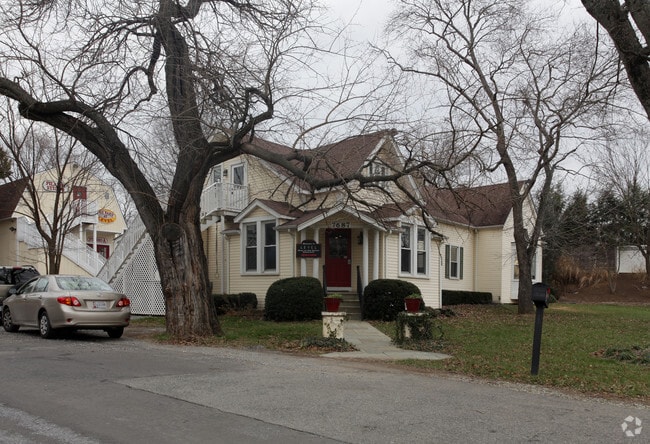


This Property Is For Sale
Property Detail
7687 Macarthur Blvd
07-03263748
CABIN JOHN PARK
Recreationalentertainmentgeneral
Montgomery
CRT07
Maryland
B and X Area of moderate flood hazard, usually the area between the limits of the 100-year and 500-year floods.
209
2024
0.48 AC
2025
Bethesda/Chevy Chase
705800
Washington, DC
3,912 SF
Washington-Arlington-Alexandria, DC-VA-MD-WV
NEARBY LISTINGS FOR SALE OR LEASE
DEMOGRAPHICS near 7687 Macarthur Blvd
1 mile
3 mile
5 mile
2025 Total Population
5,133
60,106
263,026
2030 Population
5,275
61,845
271,744
Pop Growth 2025-2030
+ 2.77%
+ 2.89%
+ 3.31%
Average Age
45
44
43
2025 Total Households
1,774
20,948
103,825
HH Growth 2025-2030
+ 2.71%
+ 2.87%
+ 3.57%
Median Household Inc
$257,315
$243,086
$196,774
Avg Household Size
2.80
2.80
2.50
2025 Avg HH Vehicles
2.00
2.00
2.00
Median Home Value
$1,106,664
$1,106,727
$1,044,700
Median Year Built
1968
1968
1972
Nearby Places
Map Layers
Map Styles
 Street
 Aerial
Layers
 Traffic
 Biking
Places
Listings with unknown addresses are not visible on the map
- Restaurants
- Banks
- Shops
- Fitness
- Groceries
PUBLIC TRANSPORTATION
COMMUTER RAIL
Garrett Park Marc Eb (BRUNSWICK - WASHINGTON - Maryland Transit Administration)
Drive
Walk
Distance
Garrett Park Marc Eb (BRUNSWICK - WASHINGTON - Maryland Transit Administration)
17 min
8.3 mi
Kensington Marc Eb (BRUNSWICK - WASHINGTON - Maryland Transit Administration)
Drive
Walk
Distance
Kensington Marc Eb (BRUNSWICK - WASHINGTON - Maryland Transit Administration)
16 min
9.6 mi
AIRPORT
Ronald Reagan Washington Ntl
Drive
Walk
Distance
Ronald Reagan Washington Ntl
27 min
13.1 mi
Washington Dulles International
Drive
Walk
Distance
Washington Dulles International
33 min
20.0 mi
Baltimore/Washington International Thurgood Marshall
Drive
Walk
Distance
Baltimore/Washington International Thurgood Marshall
54 min
40.1 mi
Freight Ports
Port of Baltimore
Drive
Walk
Distance
Port of Baltimore
59 min
42.9 mi
Nearby Properties
Address
Land Use
TOTAL SIZE
Lot Size
Zoning
Address
Land Use
TOTAL SIZE
Lot Size
Zoning
3,046,518 SF
257.86 AC
110
Address
Land Use
TOTAL SIZE
Lot Size
Zoning
556.11 AC
110
Address
Land Use
TOTAL SIZE
Lot Size
Zoning
1,180,000 SF
35.70 AC
R90
Address
Land Use
TOTAL SIZE
Lot Size
Zoning
70 AC
R200
Address
Land Use
TOTAL SIZE
Lot Size
Zoning
328.63 AC
110
Address
Land Use
TOTAL SIZE
Lot Size
Zoning
377,533 SF
4.28 AC
350
Address
Land Use
TOTAL SIZE
Lot Size
Zoning
480,249 SF
25.67 AC
R90
Address
Land Use
TOTAL SIZE
Lot Size
Zoning
236,107 SF
1.89 AC
CRT2.
Address
Land Use
TOTAL SIZE
Lot Size
Zoning
275,328 SF
61.75 AC
110
Address
Land Use
TOTAL SIZE
Lot Size
Zoning
218,981 SF
3.06 AC
IM2.5
Address
Land Use
TOTAL SIZE
Lot Size
Zoning
217,330 SF
69.73 AC
R90
Address
Land Use
TOTAL SIZE
Lot Size
Zoning
290,676 SF
54.62 AC
R200
Address
Land Use
TOTAL SIZE
Lot Size
Zoning
316,161 SF
3.30 AC
CRT2.
Address
Land Use
TOTAL SIZE
Lot Size
Zoning
364,088 SF
42.86 AC
110
Address
Land Use
TOTAL SIZE
Lot Size
Zoning
137,110 SF
16.93 AC
RE2
Address
Land Use
TOTAL SIZE
Lot Size
Zoning
220,000 SF
6.33 AC
R90
Address
Land Use
TOTAL SIZE
Lot Size
Zoning
215,347 SF
6.98 AC
NR0.7
Address
Land Use
TOTAL SIZE
Lot Size
Zoning
139,661 SF
23.88 AC
R60
Address
Land Use
TOTAL SIZE
Lot Size
Zoning
122,600 SF
40.06 AC
RE2
Address
Land Use
TOTAL SIZE
Lot Size
Zoning
110,112 SF
2.30 AC
IM1.5
Address
Land Use
TOTAL SIZE
Lot Size
Zoning
103,646 SF
2.22 AC
430
Address
Land Use
TOTAL SIZE
Lot Size
Zoning
134,440 SF
3.58 AC
R60
Address
Land Use
TOTAL SIZE
Lot Size
Zoning
130,461 SF
17.34 AC
R60
Address
Land Use
TOTAL SIZE
Lot Size
Zoning
109,810 SF
2.59 AC
R60
Address
Land Use
TOTAL SIZE
Lot Size
Zoning
105,612 SF
4.17 AC
R30
Address
Land Use
TOTAL SIZE
Lot Size
Zoning
254,100 SF
2.14 AC
CRT3.
Address
Land Use
TOTAL SIZE
Lot Size
Zoning
195.86 AC
R90
Address
Land Use
TOTAL SIZE
Lot Size
Zoning
88,450 SF
0.54 AC
IM1.5
Address
Land Use
TOTAL SIZE
Lot Size
Zoning
40,185 SF
4.90 AC
NR0.7
Address
Land Use
TOTAL SIZE
Lot Size
Zoning
32,152 SF
4.39 AC
RE2
The World's #1 Commercial Real Estate Marketplace
Connect with us
© 2026 CoStar Group
The information above has been obtained from sources believed reliable. While we do not doubt its accuracy we have not verified it and make no guarantee, warranty or representation about it. It is your responsibility to independently confirm its accuracy and completeness. Any projections, opinions, assumptions, or estimates used are for example only and do not represent the current or future performance of the property. The value of this transaction to you depends on tax and other factors which should be evaluated by your tax, financial, and legal advisors. You and your advisors should conduct a careful, independent investigation of the property to determine to your satisfaction the suitability of the property for your needs.