Property Record
7695 4Th St Se, Turner, OR 97392


Save to a Folder
{{folder.Name}}
{{folder.ListingIds.length}} Properties
{{folder.ListingIds.length}} Property
Create a New Folder
Property Detail
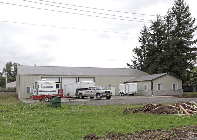
7695 4Th St Se
105658
TURNER BLOCK A LOT 1-3 & FR 4 ACRES .56
Officebuilding
MARION
M-1
Oregon
AE The base floodplain where base flood elevations are provided. AE Zones are now used on new format FIRMs instead of A1-A30 Zones.
1-3
2024
0.56 AC
2025
Marion County
002701
Portland
5,424 SF
Salem, OR
NEARBY LISTINGS FOR SALE OR LEASE
DEMOGRAPHICS near 7695 4Th St Se
1 mile
3 mile
5 mile
2025 Total Population
2,613
8,787
51,021
2030 Population
2,695
8,961
51,684
Pop Growth 2025-2030
+ 3.14%
+ 1.98%
+ 1.30%
Average Age
43
43
41
2025 Total Households
983
2,668
18,060
HH Growth 2025-2030
+ 3.36%
+ 2.21%
+ 1.40%
Median Household Inc
$99,735
$102,609
$90,149
Avg Household Size
2.60
2.70
2.60
2025 Avg HH Vehicles
2.00
2.00
2.00
Median Home Value
$636,768
$701,745
$476,114
Median Year Built
1988
1991
1992
Nearby Places
Map Layers
Map Styles
 Street
 Aerial
Layers
 Traffic
 Biking
Places
Listings with unknown addresses are not visible on the map
- Restaurants
- Banks
- Shops
- Fitness
- Groceries
PUBLIC TRANSPORTATION
COMMUTER RAIL
Salem (Amtrak Cascades - Amtrak, Coast Starlight - Amtrak)
Drive
Walk
Distance
Salem (Amtrak Cascades - Amtrak, Coast Starlight - Amtrak)
16 min
8.3 mi
Freight Ports
Port of Portland
Drive
Walk
Distance
Port of Portland
74 min
56.5 mi
Nearby Properties
Address
Land Use
TOTAL SIZE
Lot Size
Zoning
Address
Land Use
TOTAL SIZE
Lot Size
Zoning
412,248 SF
27.80 AC
Address
Land Use
TOTAL SIZE
Lot Size
Zoning
310,408 SF
203.73 AC
PH; PE
Address
Land Use
TOTAL SIZE
Lot Size
Zoning
127,442 SF
8.69 AC
R-11
Address
Land Use
TOTAL SIZE
Lot Size
Zoning
59,705 SF
10.08 AC
UT-10
Address
Land Use
TOTAL SIZE
Lot Size
Zoning
48,762 SF
8.78 AC
P-1; R-11
Address
Land Use
TOTAL SIZE
Lot Size
Zoning
74,519 SF
36.38 AC
R-2
Address
Land Use
TOTAL SIZE
Lot Size
Zoning
Address
Land Use
TOTAL SIZE
Lot Size
Zoning
30,320 SF
3.06 AC
R-11
Address
Land Use
TOTAL SIZE
Lot Size
Zoning
36,213 SF
C
Address
Land Use
TOTAL SIZE
Lot Size
Zoning
26.17 AC
EC
Address
Land Use
TOTAL SIZE
Lot Size
Zoning
Address
Land Use
TOTAL SIZE
Lot Size
Zoning
12,930 SF
1.79 AC
P-1
Address
Land Use
TOTAL SIZE
Lot Size
Zoning
36,720 SF
5 AC
M-1
Address
Land Use
TOTAL SIZE
Lot Size
Zoning
38,401 SF
19.74 AC
R-2
Address
Land Use
TOTAL SIZE
Lot Size
Zoning
55,915 SF
9.55 AC
UT-10
Address
Land Use
TOTAL SIZE
Lot Size
Zoning
31,088 SF
188.73 AC
EFU; SA
Address
Land Use
TOTAL SIZE
Lot Size
Zoning
13,560 SF
5.81 AC
M-1
Address
Land Use
TOTAL SIZE
Lot Size
Zoning
21,000 SF
3.40 AC
UT-10
Address
Land Use
TOTAL SIZE
Lot Size
Zoning
31,100 SF
4.77 AC
UT-10
Address
Land Use
TOTAL SIZE
Lot Size
Zoning
5.11 AC
M-1
Address
Land Use
TOTAL SIZE
Lot Size
Zoning
9,359 SF
98.84 AC
EFU
Address
Land Use
TOTAL SIZE
Lot Size
Zoning
9,029 SF
11.88 AC
SA
Address
Land Use
TOTAL SIZE
Lot Size
Zoning
5,010 SF
0.96 AC
P-1
Address
Land Use
TOTAL SIZE
Lot Size
Zoning
10,800 SF
0.43 AC
C-1
Address
Land Use
TOTAL SIZE
Lot Size
Zoning
22,752 SF
2.62 AC
C-1; R-1
Address
Land Use
TOTAL SIZE
Lot Size
Zoning
9,168 SF
0.78 AC
R-11
Address
Land Use
TOTAL SIZE
Lot Size
Zoning
29,448 SF
158.43 AC
EFU
Address
Land Use
TOTAL SIZE
Lot Size
Zoning
18,838 SF
26.25 AC
SA
Address
Land Use
TOTAL SIZE
Lot Size
Zoning
9,002 SF
1.37 AC
P-1; C-1
The World's #1 Commercial Real Estate Marketplace
Connect with us
© 2026 CoStar Group
The information above has been obtained from sources believed reliable. While we do not doubt its accuracy we have not verified it and make no guarantee, warranty or representation about it. It is your responsibility to independently confirm its accuracy and completeness. Any projections, opinions, assumptions, or estimates used are for example only and do not represent the current or future performance of the property. The value of this transaction to you depends on tax and other factors which should be evaluated by your tax, financial, and legal advisors. You and your advisors should conduct a careful, independent investigation of the property to determine to your satisfaction the suitability of the property for your needs.