Property Record
77 E Wilson Bridge Rd, Worthington, OH 43085
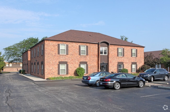

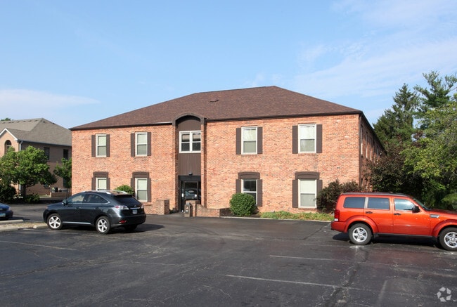
Property Detail
77 E Wilson Bridge Rd
Columbus, OH
77 E WILSON BRIDGE NORTHIGH ACRES LOT 5
100-002675
Franklin
Officebuilding
Ohio
2024
5
2025
0.96 AC
006722
Worthington
16,689 SF
Columbus
NEARBY LISTINGS FOR SALE OR LEASE
DEMOGRAPHICS near 77 E Wilson Bridge Rd
1 mile
3 mile
5 mile
2025 Total Population
8,069
101,286
290,878
2030 Population
8,250
103,995
299,904
Pop Growth 2025-2030
+ 2.24%
+ 2.67%
+ 3.10%
Average Age
41
38
38
2025 Total Households
3,448
42,339
120,659
HH Growth 2025-2030
+ 2.41%
+ 2.90%
+ 3.26%
Median Household Inc
$99,159
$87,218
$83,251
Avg Household Size
2.20
2.30
2.30
2025 Avg HH Vehicles
2.00
2.00
2.00
Median Home Value
$409,661
$346,724
$347,374
Median Year Built
1974
1980
1980
Nearby Places
Map Layers
Map Styles
 Street
 Aerial
Layers
 Traffic
 Biking
Places
Listings with unknown addresses are not visible on the map
- Restaurants
- Banks
- Shops
- Fitness
- Groceries
PUBLIC TRANSPORTATION
AIRPORT
John Glenn Columbus International
Drive
Walk
Distance
John Glenn Columbus International
16 min
15.4 mi
Freight Ports
Port of Baltimore
Drive
Walk
Distance
Port of Baltimore
1 min
346.1 mi
Nearby Properties
Address
Land Use
TOTAL SIZE
Lot Size
Zoning
Address
Land Use
TOTAL SIZE
Lot Size
Zoning
423,799 SF
9 AC
Address
Land Use
TOTAL SIZE
Lot Size
Zoning
2,140,832 SF
89.50 AC
Address
Land Use
TOTAL SIZE
Lot Size
Zoning
133,425 SF
0.44 AC
Address
Land Use
TOTAL SIZE
Lot Size
Zoning
153,766 SF
3.98 AC
Address
Land Use
TOTAL SIZE
Lot Size
Zoning
320,155 SF
84.68 AC
Address
Land Use
TOTAL SIZE
Lot Size
Zoning
206,724 SF
7.60 AC
Address
Land Use
TOTAL SIZE
Lot Size
Zoning
171,631 SF
17.55 AC
Address
Land Use
TOTAL SIZE
Lot Size
Zoning
356,770 SF
2.65 AC
Address
Land Use
TOTAL SIZE
Lot Size
Zoning
286,169 SF
11.08 AC
Address
Land Use
TOTAL SIZE
Lot Size
Zoning
217,722 SF
67.75 AC
Address
Land Use
TOTAL SIZE
Lot Size
Zoning
261,872 SF
53.89 AC
Address
Land Use
TOTAL SIZE
Lot Size
Zoning
109,480 SF
17.86 AC
Address
Land Use
TOTAL SIZE
Lot Size
Zoning
62,852 SF
15.56 AC
Address
Land Use
TOTAL SIZE
Lot Size
Zoning
249,917 SF
19.18 AC
Address
Land Use
TOTAL SIZE
Lot Size
Zoning
38,976 SF
22.86 AC
Address
Land Use
TOTAL SIZE
Lot Size
Zoning
266,792 SF
9.03 AC
Address
Land Use
TOTAL SIZE
Lot Size
Zoning
413,781 SF
78.36 AC
Address
Land Use
TOTAL SIZE
Lot Size
Zoning
428,656 SF
6.42 AC
Address
Land Use
TOTAL SIZE
Lot Size
Zoning
162,728 SF
4.80 AC
Address
Land Use
TOTAL SIZE
Lot Size
Zoning
187,562 SF
8.76 AC
Address
Land Use
TOTAL SIZE
Lot Size
Zoning
62,702 SF
38.69 AC
Address
Land Use
TOTAL SIZE
Lot Size
Zoning
132,804 SF
11.54 AC
Address
Land Use
TOTAL SIZE
Lot Size
Zoning
273,264 SF
7.35 AC
Address
Land Use
TOTAL SIZE
Lot Size
Zoning
183,424 SF
9.21 AC
Address
Land Use
TOTAL SIZE
Lot Size
Zoning
170,237 SF
97.38 AC
Address
Land Use
TOTAL SIZE
Lot Size
Zoning
368,077 SF
7.87 AC
Address
Land Use
TOTAL SIZE
Lot Size
Zoning
184,756 SF
23.53 AC
Address
Land Use
TOTAL SIZE
Lot Size
Zoning
69.13 AC
Address
Land Use
TOTAL SIZE
Lot Size
Zoning
148.89 AC
Address
Land Use
TOTAL SIZE
Lot Size
Zoning
24,004 SF
20.30 AC
The World's #1 Commercial Real Estate Marketplace
Connect with us
© 2026 CoStar Group
The information above has been obtained from sources believed reliable. While we do not doubt its accuracy we have not verified it and make no guarantee, warranty or representation about it. It is your responsibility to independently confirm its accuracy and completeness. Any projections, opinions, assumptions, or estimates used are for example only and do not represent the current or future performance of the property. The value of this transaction to you depends on tax and other factors which should be evaluated by your tax, financial, and legal advisors. You and your advisors should conduct a careful, independent investigation of the property to determine to your satisfaction the suitability of the property for your needs.