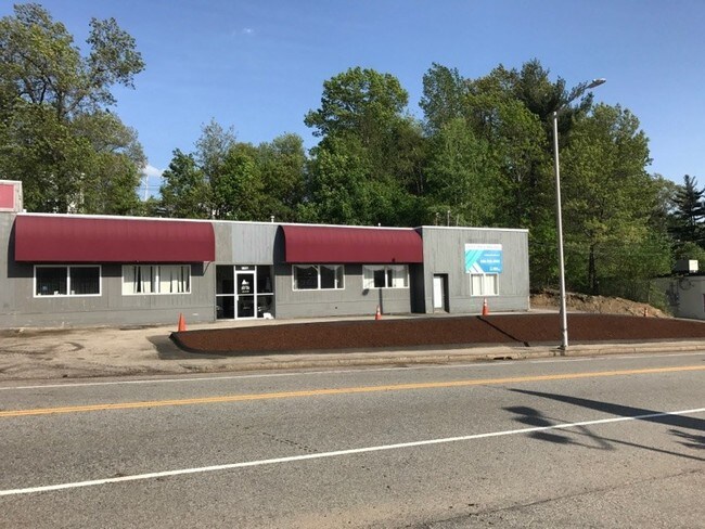
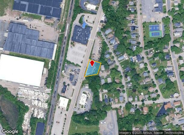
Property Record
770 W Boylston St, Worcester, MA 01606

NEARBY LISTINGS FOR SALE OR LEASE
Property Detail
770 W Boylston St
WORC-000023-000012-000009-000010
City Worcester
Religious
Worcester
X
Massachusetts
25027C0610F
9+10
2024
0.37 AC
2025
Worcester Metro
730300
Boston
5,513 SF
Worcester, MA
DEMOGRAPHICS near 770 W Boylston St
1 mile
3 mile
5 mile
2024 Total Population
9,894
64,333
190,219
2029 Population
9,739
63,716
188,135
Pop Growth 2024-2029
(1.57%)
(0.96%)
(1.10%)
Average Age
42
40
39
2024 Total Households
4,193
24,731
73,504
HH Growth 2024-2029
(1.60%)
(0.99%)
(1.10%)
Median Household Inc
$85,448
$80,655
$71,361
Avg Household Size
2.30
2.40
2.40
2024 Avg HH Vehicles
2.00
2.00
2.00
Median Home Value
$301,328
$336,231
$362,436
Median Year Built
1951
1957
1954
Nearby Places
Map Layers
Map Styles
 Street
 Aerial
Transit
 Traffic
 Biking
Places
Listings with unknown addresses are not visible on the map
- Restaurants
- Banks
- Shops
- Fitness
- Groceries
PUBLIC TRANSPORTATION
COMMUTER RAIL
Worcester (Framingham/Worcester Line - Massachusetts Bay Transportation Authority Commuter Rail (Purple Line))
Drive
Walk
Distance
Worcester (Framingham/Worcester Line - Massachusetts Bay Transportation Authority Commuter Rail (Purple Line))
16 min
5.9 mi
Grafton (Framingham/Worcester Line - Massachusetts Bay Transportation Authority Commuter Rail (Purple Line))
Drive
Walk
Distance
Grafton (Framingham/Worcester Line - Massachusetts Bay Transportation Authority Commuter Rail (Purple Line))
23 min
9.7 mi
Freight Ports
Port of Boston
Drive
Walk
Distance
Port of Boston
1 min
39.4 mi
SALE & LEASE HISTORY
LISTING DATE
SALE/LEASE

Sep 24, 2016
For Sale
May 15, 2017
For Sale
Feb 22, 2017
For Lease
Feb 22, 2017
For Sale
Nearby Properties
Address
Land Use
TOTAL SIZE
Lot Size
Zoning
Address
Land Use
TOTAL SIZE
Lot Size
Zoning
155,421 SF
65.04 AC
RL-7
Address
Land Use
TOTAL SIZE
Lot Size
Zoning
524,527 SF
45.16 AC
BL-1
Address
Land Use
TOTAL SIZE
Lot Size
Zoning
51.05 AC
BO-1
Address
Land Use
TOTAL SIZE
Lot Size
Zoning
295,000 SF
194.17 AC
RUR B
Address
Land Use
TOTAL SIZE
Lot Size
Zoning
50.11 AC
RS-7
Address
Land Use
TOTAL SIZE
Lot Size
Zoning
16,404 SF
10.80 AC
RS-10
Address
Land Use
TOTAL SIZE
Lot Size
Zoning
126,849 SF
15.18 AC
R15
Address
Land Use
TOTAL SIZE
Lot Size
Zoning
30.93 AC
RG-5
Address
Land Use
TOTAL SIZE
Lot Size
Zoning
291,410 SF
21.73 AC
RL-7
Address
Land Use
TOTAL SIZE
Lot Size
Zoning
44,584 SF
90.22 AC
Address
Land Use
TOTAL SIZE
Lot Size
Zoning
194,264 SF
4.32 AC
BL-1
Address
Land Use
TOTAL SIZE
Lot Size
Zoning
15.37 AC
RS-7
Address
Land Use
TOTAL SIZE
Lot Size
Zoning
120,046 SF
6.90 AC
RG-5
Address
Land Use
TOTAL SIZE
Lot Size
Zoning
118,682 SF
7.33 AC
RG-5
Address
Land Use
TOTAL SIZE
Lot Size
Zoning
118,381 SF
12.61 AC
RG-5
Address
Land Use
TOTAL SIZE
Lot Size
Zoning
13.95 AC
RG-5
Address
Land Use
TOTAL SIZE
Lot Size
Zoning
286,338 SF
33.45 AC
RL-7
Address
Land Use
TOTAL SIZE
Lot Size
Zoning
120,732 SF
28.92 AC
RS-10
Address
Land Use
TOTAL SIZE
Lot Size
Zoning
153,482 SF
5.95 AC
MG-1
Address
Land Use
TOTAL SIZE
Lot Size
Zoning
6.70 AC
RG-5
Address
Land Use
TOTAL SIZE
Lot Size
Zoning
145,068 SF
16.35 AC
BG-3
Address
Land Use
TOTAL SIZE
Lot Size
Zoning
121,504 SF
3.75 AC
BG-3
Address
Land Use
TOTAL SIZE
Lot Size
Zoning
96,541 SF
5.24 AC
MG-5
Address
Land Use
TOTAL SIZE
Lot Size
Zoning
24,243 SF
168.59 AC
Address
Land Use
TOTAL SIZE
Lot Size
Zoning
137,290 SF
10.51 AC
RS-7
Address
Land Use
TOTAL SIZE
Lot Size
Zoning
29.20 AC
RS-7
Address
Land Use
TOTAL SIZE
Lot Size
Zoning
2,340 SF
22.44 AC
RL7
Address
Land Use
TOTAL SIZE
Lot Size
Zoning
40,733 SF
4.93 AC
LIM CO
Address
Land Use
TOTAL SIZE
Lot Size
Zoning
235,155 SF
11.61 AC
MG-2
Address
Land Use
TOTAL SIZE
Lot Size
Zoning
5.13 AC
RG-5
The World's #1 Commercial Real Estate Marketplace
Connect with us
© 2026 CoStar Group
The information above has been obtained from sources believed reliable. While we do not doubt its accuracy we have not verified it and make no guarantee, warranty or representation about it. It is your responsibility to independently confirm its accuracy and completeness. Any projections, opinions, assumptions, or estimates used are for example only and do not represent the current or future performance of the property. The value of this transaction to you depends on tax and other factors which should be evaluated by your tax, financial, and legal advisors. You and your advisors should conduct a careful, independent investigation of the property to determine to your satisfaction the suitability of the property for your needs.