Property Record
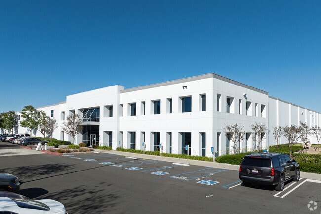
771 E Watson Center Rd, Carson, CA 90745


Property Detail
771 E Watson Center Rd
7315-005-049
PM 194-93 THAT POR IN TRA 1015 LOT 2
Warehouse
Los Angeles
CAMH*
California
B and X Area of moderate flood hazard, usually the area between the limits of the 100-year and 500-year floods.
2
2024
9.92 AC
2025
Carson
543905
Los Angeles
252,174 SF
Los Angeles-Long Beach-Glendale, CA
NEARBY LISTINGS FOR SALE OR LEASE
DEMOGRAPHICS near 771 E Watson Center Rd
1 mile
3 mile
5 mile
2025 Total Population
28,398
191,753
478,306
2030 Population
27,943
189,380
473,489
Pop Growth 2025-2030
(1.60%)
(1.24%)
(1.01%)
Average Age
43
41
41
2025 Total Households
7,316
55,796
151,786
HH Growth 2025-2030
(1.91%)
(1.45%)
(1.20%)
Median Household Inc
$108,093
$91,154
$86,969
Avg Household Size
3.50
3.20
3.00
2025 Avg HH Vehicles
3.00
2.00
2.00
Median Home Value
$676,565
$703,342
$736,195
Median Year Built
1962
1964
1964
Nearby Places
Map Layers
Map Styles
 Street
 Aerial
Transit
 Traffic
 Biking
Places
Listings with unknown addresses are not visible on the map
- Restaurants
- Banks
- Shops
- Fitness
- Groceries
PUBLIC TRANSPORTATION
AIRPORT
Long Beach (Daugherty Field)
Drive
Walk
Distance
Long Beach (Daugherty Field)
12 min
6.5 mi
Los Angeles International
Drive
Walk
Distance
Los Angeles International
22 min
15.1 mi
John Wayne/Orange County
Drive
Walk
Distance
John Wayne/Orange County
35 min
26.8 mi
Nearby Properties
Address
Land Use
TOTAL SIZE
Lot Size
Zoning
Address
Land Use
TOTAL SIZE
Lot Size
Zoning
236,582 SF
425.41 AC
CAMH*
Address
Land Use
TOTAL SIZE
Lot Size
Zoning
64,456 SF
11.71 AC
CASP-10*
Address
Land Use
TOTAL SIZE
Lot Size
Zoning
506,189 SF
20.33 AC
LAM2
Address
Land Use
TOTAL SIZE
Lot Size
Zoning
286,186 SF
8.20 AC
LAMR1
Address
Land Use
TOTAL SIZE
Lot Size
Zoning
108,891 SF
224.14 AC
CAMH*
Address
Land Use
TOTAL SIZE
Lot Size
Zoning
246,981 SF
11.95 AC
LARD2
Address
Land Use
TOTAL SIZE
Lot Size
Zoning
285,314 SF
14.28 AC
CAMH*
Address
Land Use
TOTAL SIZE
Lot Size
Zoning
84,365 SF
7.62 AC
LARAS3
Address
Land Use
TOTAL SIZE
Lot Size
Zoning
513,520 SF
19.09 AC
LBPD26
Address
Land Use
TOTAL SIZE
Lot Size
Zoning
260,766 SF
10.70 AC
LAM3
Address
Land Use
TOTAL SIZE
Lot Size
Zoning
429,141 SF
3.29 AC
LCM1*
Address
Land Use
TOTAL SIZE
Lot Size
Zoning
383,109 SF
17 AC
LCM2
Address
Land Use
TOTAL SIZE
Lot Size
Zoning
198,502 SF
LCM2 *
Address
Land Use
TOTAL SIZE
Lot Size
Zoning
1,800 SF
124.45 AC
CAMH*
Address
Land Use
TOTAL SIZE
Lot Size
Zoning
213,408 SF
13.81 AC
LBR4R
Address
Land Use
TOTAL SIZE
Lot Size
Zoning
350,896 SF
13.43 AC
LBML*
Address
Land Use
TOTAL SIZE
Lot Size
Zoning
135,666 SF
LAM3
Address
Land Use
TOTAL SIZE
Lot Size
Zoning
365,701 SF
2.45 AC
TOMI-BP
Address
Land Use
TOTAL SIZE
Lot Size
Zoning
14.80 AC
CAMH*
Address
Land Use
TOTAL SIZE
Lot Size
Zoning
340,121 SF
13 AC
LCM2
Address
Land Use
TOTAL SIZE
Lot Size
Zoning
10.30 AC
TOM2*
Address
Land Use
TOTAL SIZE
Lot Size
Zoning
178,323 SF
12.23 AC
CACR&D&MUR
Address
Land Use
TOTAL SIZE
Lot Size
Zoning
546,606 SF
17.58 AC
LAM3
Address
Land Use
TOTAL SIZE
Lot Size
Zoning
169,056 SF
10.04 AC
LBR4R
Address
Land Use
TOTAL SIZE
Lot Size
Zoning
499,562 SF
6.50 AC
LAM3
Address
Land Use
TOTAL SIZE
Lot Size
Zoning
496,472 SF
21.57 AC
CAMH*
Address
Land Use
TOTAL SIZE
Lot Size
Zoning
110,190 SF
5.16 AC
CAMH*
Address
Land Use
TOTAL SIZE
Lot Size
Zoning
105,853 SF
9.98 AC
CACA*
Address
Land Use
TOTAL SIZE
Lot Size
Zoning
291,508 SF
15.21 AC
LBR4R
Address
Land Use
TOTAL SIZE
Lot Size
Zoning
354,980 SF
8.36 AC
CAMH*
The World's #1 Commercial Real Estate Marketplace
Connect with us
© 2026 CoStar Group
The information above has been obtained from sources believed reliable. While we do not doubt its accuracy we have not verified it and make no guarantee, warranty or representation about it. It is your responsibility to independently confirm its accuracy and completeness. Any projections, opinions, assumptions, or estimates used are for example only and do not represent the current or future performance of the property. The value of this transaction to you depends on tax and other factors which should be evaluated by your tax, financial, and legal advisors. You and your advisors should conduct a careful, independent investigation of the property to determine to your satisfaction the suitability of the property for your needs.