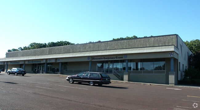
Property Record
771 Route 113, Souderton, PA 18964

Property Detail
771 Route 113
15-008-017
7.2208AC W S US309 784 F T N T423
Regionalshoppingcenterormallwithanchorstore
BUCKS
PC1
Pennsylvania
B and X Area of moderate flood hazard, usually the area between the limits of the 100-year and 500-year floods.
7.22 AC
2025
Upper Bucks County
2026
Philadelphia
207201
Philadelphia-Camden-Wilmington, PA-NJ-DE-MD
65,800 SF
NEARBY LISTINGS FOR SALE OR LEASE
DEMOGRAPHICS near 771 Route 113
1 mile
3 mile
5 mile
2025 Total Population
6,725
50,767
110,166
2030 Population
6,876
52,418
112,786
Pop Growth 2025-2030
+ 2.25%
+ 3.25%
+ 2.38%
Average Age
42
42
43
2025 Total Households
2,766
19,299
41,715
HH Growth 2025-2030
+ 2.28%
+ 2.92%
+ 2.22%
Median Household Inc
$89,856
$97,917
$104,235
Avg Household Size
2.40
2.50
2.60
2025 Avg HH Vehicles
2.00
2.00
2.00
Median Home Value
$351,901
$400,282
$424,869
Median Year Built
1974
1980
1978
Nearby Places
Map Layers
Map Styles
 Street
 Aerial
Layers
 Traffic
 Biking
Places
Listings with unknown addresses are not visible on the map
- Restaurants
- Banks
- Shops
- Fitness
- Groceries
PUBLIC TRANSPORTATION
COMMUTER RAIL
Link Belt (R5 - Southeastern Pennsylvania Transportation Authority Regional Rail (SEPTA Regional Rail))
Drive
Walk
Distance
Link Belt (R5 - Southeastern Pennsylvania Transportation Authority Regional Rail (SEPTA Regional Rail))
8 min
4.8 mi
Colmar (R5 - Southeastern Pennsylvania Transportation Authority Regional Rail (SEPTA Regional Rail))
Drive
Walk
Distance
Colmar (R5 - Southeastern Pennsylvania Transportation Authority Regional Rail (SEPTA Regional Rail))
9 min
4.8 mi
AIRPORT
Lehigh Valley International
Drive
Walk
Distance
Lehigh Valley International
47 min
28.7 mi
Trenton Mercer
Drive
Walk
Distance
Trenton Mercer
59 min
34.8 mi
Freight Ports
Port of Philadelphia
Drive
Walk
Distance
Port of Philadelphia
48 min
29.0 mi
SALE & LEASE HISTORY
LISTING DATE
SALE/LEASE

Dec 09, 2024
For Lease
Apr 10, 2025
For Lease
Nearby Properties
Address
Land Use
TOTAL SIZE
Lot Size
Zoning
Address
Land Use
TOTAL SIZE
Lot Size
Zoning
977,439 SF
70.93 AC
GA
Address
Land Use
TOTAL SIZE
Lot Size
Zoning
474,793 SF
40.91 AC
I
Address
Land Use
TOTAL SIZE
Lot Size
Zoning
139,733 SF
46.65 AC
R130
Address
Land Use
TOTAL SIZE
Lot Size
Zoning
349,078 SF
18.46 AC
INST
Address
Land Use
TOTAL SIZE
Lot Size
Zoning
253,915 SF
17.78 AC
GA
Address
Land Use
TOTAL SIZE
Lot Size
Zoning
152,085 SF
38.16 AC
INST
Address
Land Use
TOTAL SIZE
Lot Size
Zoning
444,718 SF
46.51 AC
LI
Address
Land Use
TOTAL SIZE
Lot Size
Zoning
324,796 SF
42.20 AC
LI
Address
Land Use
TOTAL SIZE
Lot Size
Zoning
502,169 SF
83.16 AC
LI
Address
Land Use
TOTAL SIZE
Lot Size
Zoning
333,888 SF
35.37 AC
LI
Address
Land Use
TOTAL SIZE
Lot Size
Zoning
214,042 SF
26.53 AC
LI
Address
Land Use
TOTAL SIZE
Lot Size
Zoning
230,016 SF
11.27 AC
LI
Address
Land Use
TOTAL SIZE
Lot Size
Zoning
65,178 SF
16.86 AC
B
Address
Land Use
TOTAL SIZE
Lot Size
Zoning
94,598 SF
27.72 AC
INST
Address
Land Use
TOTAL SIZE
Lot Size
Zoning
77,878 SF
17.60 AC
INST
Address
Land Use
TOTAL SIZE
Lot Size
Zoning
182,010 SF
12.25 AC
LI
Address
Land Use
TOTAL SIZE
Lot Size
Zoning
40,754 SF
6.23 AC
LI
Address
Land Use
TOTAL SIZE
Lot Size
Zoning
95,494 SF
13.67 AC
C
Address
Land Use
TOTAL SIZE
Lot Size
Zoning
143,800 SF
10.25 AC
C
Address
Land Use
TOTAL SIZE
Lot Size
Zoning
60,620 SF
14.60 AC
ER
Address
Land Use
TOTAL SIZE
Lot Size
Zoning
85,508 SF
25.83 AC
Address
Land Use
TOTAL SIZE
Lot Size
Zoning
237,667 SF
37.86 AC
LI
Address
Land Use
TOTAL SIZE
Lot Size
Zoning
121,762 SF
16.66 AC
LI
Address
Land Use
TOTAL SIZE
Lot Size
Zoning
63,183 SF
23.05 AC
INST
Address
Land Use
TOTAL SIZE
Lot Size
Zoning
90,211 SF
1.38 AC
C
Address
Land Use
TOTAL SIZE
Lot Size
Zoning
71,431 SF
2.65 AC
R2
Address
Land Use
TOTAL SIZE
Lot Size
Zoning
128,619 SF
7.61 AC
LI
Address
Land Use
TOTAL SIZE
Lot Size
Zoning
134,704 SF
34.23 AC
PC1
Address
Land Use
TOTAL SIZE
Lot Size
Zoning
146,539 SF
12.68 AC
LI
Address
Land Use
TOTAL SIZE
Lot Size
Zoning
53,795 SF
3.64 AC
INST
The World's #1 Commercial Real Estate Marketplace
Connect with us
© 2026 CoStar Group
The information above has been obtained from sources believed reliable. While we do not doubt its accuracy we have not verified it and make no guarantee, warranty or representation about it. It is your responsibility to independently confirm its accuracy and completeness. Any projections, opinions, assumptions, or estimates used are for example only and do not represent the current or future performance of the property. The value of this transaction to you depends on tax and other factors which should be evaluated by your tax, financial, and legal advisors. You and your advisors should conduct a careful, independent investigation of the property to determine to your satisfaction the suitability of the property for your needs.