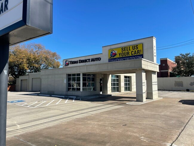
Property Record
7730 Westheimer Rd, Houston, TX 77063

Property Detail
7730 Westheimer Rd
0881800000019
RES B BLK 8 BRIARBEND
Storebuilding
HARRIS
B and X Area of moderate flood hazard, usually the area between the limits of the 100-year and 500-year floods.
Texas
2025
0.35 AC
2025
Near West
431204
Houston
4,684 SF
Houston-Pasadena-The Woodlands, TX
NEARBY LISTINGS FOR SALE OR LEASE
DEMOGRAPHICS near 7730 Westheimer Rd
1 mile
3 mile
5 mile
2025 Total Population
38,493
237,868
571,831
2030 Population
41,220
254,697
612,695
Pop Growth 2025-2030
+ 7.08%
+ 7.07%
+ 7.15%
Average Age
35
37
37
2025 Total Households
18,222
104,619
239,729
HH Growth 2025-2030
+ 7.32%
+ 7.29%
+ 7.39%
Median Household Inc
$55,916
$59,285
$67,816
Avg Household Size
2.10
2.20
2.30
2025 Avg HH Vehicles
1.00
1.00
2.00
Median Home Value
$421,463
$507,202
$552,848
Median Year Built
1976
1979
1981
Nearby Places
Map Layers
Map Styles
 Street
 Aerial
Layers
 Traffic
 Biking
Places
Listings with unknown addresses are not visible on the map
- Restaurants
- Banks
- Shops
- Fitness
- Groceries
PUBLIC TRANSPORTATION
AIRPORT
William P Hobby
Drive
Walk
Distance
William P Hobby
36 min
21.0 mi
George Bush Intcntl/Houston
Drive
Walk
Distance
George Bush Intcntl/Houston
39 min
28.4 mi
Freight Ports
Port of Houston
Drive
Walk
Distance
Port of Houston
32 min
20.3 mi
SALE & LEASE HISTORY
LISTING DATE
SALE/LEASE

Mar 04, 2022
For Lease
Nearby Properties
Address
Land Use
TOTAL SIZE
Lot Size
Zoning
Address
Land Use
TOTAL SIZE
Lot Size
Zoning
576,253 SF
5.91 AC
Address
Land Use
TOTAL SIZE
Lot Size
Zoning
2,404,389 SF
16.01 AC
Address
Land Use
TOTAL SIZE
Lot Size
Zoning
2,626,393 SF
6.70 AC
Address
Land Use
TOTAL SIZE
Lot Size
Zoning
580,059 SF
2.48 AC
Address
Land Use
TOTAL SIZE
Lot Size
Zoning
329,832 SF
1.75 AC
Address
Land Use
TOTAL SIZE
Lot Size
Zoning
1,062,592 SF
7.41 AC
Address
Land Use
TOTAL SIZE
Lot Size
Zoning
608,704 SF
1.52 AC
Address
Land Use
TOTAL SIZE
Lot Size
Zoning
771,702 SF
2.51 AC
Address
Land Use
TOTAL SIZE
Lot Size
Zoning
576,200 SF
2.65 AC
Address
Land Use
TOTAL SIZE
Lot Size
Zoning
527,312 SF
2.58 AC
Address
Land Use
TOTAL SIZE
Lot Size
Zoning
612,663 SF
7 AC
Address
Land Use
TOTAL SIZE
Lot Size
Zoning
392,218 SF
1.21 AC
Address
Land Use
TOTAL SIZE
Lot Size
Zoning
305,760 SF
2.22 AC
Address
Land Use
TOTAL SIZE
Lot Size
Zoning
1,012,117 SF
3.29 AC
Address
Land Use
TOTAL SIZE
Lot Size
Zoning
1,819,963 SF
5.30 AC
Address
Land Use
TOTAL SIZE
Lot Size
Zoning
214,297 SF
15.23 AC
Address
Land Use
TOTAL SIZE
Lot Size
Zoning
878,129 SF
11.69 AC
Address
Land Use
TOTAL SIZE
Lot Size
Zoning
415,160 SF
4.47 AC
Address
Land Use
TOTAL SIZE
Lot Size
Zoning
128,404 SF
2.88 AC
Address
Land Use
TOTAL SIZE
Lot Size
Zoning
323,456 SF
3.91 AC
Address
Land Use
TOTAL SIZE
Lot Size
Zoning
133,258 SF
11.56 AC
Address
Land Use
TOTAL SIZE
Lot Size
Zoning
702,286 SF
15.67 AC
Address
Land Use
TOTAL SIZE
Lot Size
Zoning
561,732 SF
6.10 AC
Address
Land Use
TOTAL SIZE
Lot Size
Zoning
281,973 SF
11.56 AC
Address
Land Use
TOTAL SIZE
Lot Size
Zoning
126,877 SF
34.71 AC
Address
Land Use
TOTAL SIZE
Lot Size
Zoning
521,287 SF
3.90 AC
Address
Land Use
TOTAL SIZE
Lot Size
Zoning
385,587 SF
3.08 AC
Address
Land Use
TOTAL SIZE
Lot Size
Zoning
597,397 SF
2.93 AC
Address
Land Use
TOTAL SIZE
Lot Size
Zoning
1,011,299 SF
4 AC
Address
Land Use
TOTAL SIZE
Lot Size
Zoning
589,957 SF
5.30 AC
The World's #1 Commercial Real Estate Marketplace
Connect with us
© 2026 CoStar Group
The information above has been obtained from sources believed reliable. While we do not doubt its accuracy we have not verified it and make no guarantee, warranty or representation about it. It is your responsibility to independently confirm its accuracy and completeness. Any projections, opinions, assumptions, or estimates used are for example only and do not represent the current or future performance of the property. The value of this transaction to you depends on tax and other factors which should be evaluated by your tax, financial, and legal advisors. You and your advisors should conduct a careful, independent investigation of the property to determine to your satisfaction the suitability of the property for your needs.