Property Record
7741 Wagoner Rd, Fairhope, AL 36532
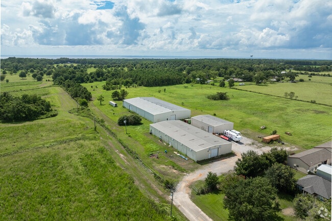

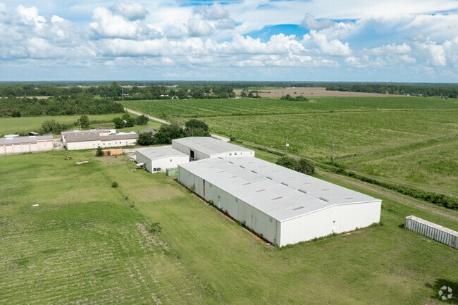

Property Detail
7741 Wagoner Rd
56-03-08-0-000-001.009
20.2 AC COM AT THE SE COR OF NE1/4 SEC 8 RUN W 1351.02' FORTHE POB, TH CONT W 1313.5', TH N 670', TH E 1316', TH S 669.5' TO
Warehouse
BALDWIN
B and X Area of moderate flood hazard, usually the area between the limits of the 100-year and 500-year floods.
Alabama
2025
20 AC
2025
Baldwin County
011300
Mobile
20,000 SF
Daphne-Fairhope-Foley, AL
NEARBY LISTINGS FOR SALE OR LEASE
-
-
View all Fairhope listings for sale on LoopNet.com
DEMOGRAPHICS near 7741 Wagoner Rd
1 mile
3 mile
5 mile
2025 Total Population
336
6,061
23,941
2030 Population
368
6,645
26,196
Pop Growth 2025-2030
+ 9.52%
+ 9.64%
+ 9.42%
Average Age
45
44
44
2025 Total Households
130
2,367
9,538
HH Growth 2025-2030
+ 9.23%
+ 9.59%
+ 9.44%
Median Household Inc
$82,630
$79,707
$76,024
Avg Household Size
2.50
2.50
2.40
2025 Avg HH Vehicles
3.00
2.00
2.00
Median Home Value
$621,323
$434,177
$365,922
Median Year Built
2008
2001
2000
Nearby Places
Map Layers
Map Styles
 Street
 Aerial
Layers
 Traffic
 Biking
Places
Listings with unknown addresses are not visible on the map
- Restaurants
- Banks
- Shops
- Fitness
- Groceries
PUBLIC TRANSPORTATION
AIRPORT
Mobile International
Drive
Walk
Distance
Mobile International
42 min
28.0 mi
Mobile Regional
Drive
Walk
Distance
Mobile Regional
65 min
41.6 mi
Freight Ports
Port of Mobile
Drive
Walk
Distance
Port of Mobile
37 min
24.6 mi
SALE & LEASE HISTORY
LISTING DATE
SALE/LEASE

Feb 24, 2023
For Sale
Nearby Properties
Address
Land Use
TOTAL SIZE
Lot Size
Zoning
Address
Land Use
TOTAL SIZE
Lot Size
Zoning
3,936 SF
41 AC
Address
Land Use
TOTAL SIZE
Lot Size
Zoning
66,365 SF
15 AC
Address
Land Use
TOTAL SIZE
Lot Size
Zoning
47,326 SF
29 AC
Address
Land Use
TOTAL SIZE
Lot Size
Zoning
21,357 SF
33 AC
Address
Land Use
TOTAL SIZE
Lot Size
Zoning
4,332 SF
57 AC
Address
Land Use
TOTAL SIZE
Lot Size
Zoning
2,924 SF
17 AC
Address
Land Use
TOTAL SIZE
Lot Size
Zoning
31,991 SF
7.40 AC
Address
Land Use
TOTAL SIZE
Lot Size
Zoning
3,642 SF
3.34 AC
Address
Land Use
TOTAL SIZE
Lot Size
Zoning
179 SF
84 AC
Address
Land Use
TOTAL SIZE
Lot Size
Zoning
Address
Land Use
TOTAL SIZE
Lot Size
Zoning
Address
Land Use
TOTAL SIZE
Lot Size
Zoning
7,500 SF
1.35 AC
Address
Land Use
TOTAL SIZE
Lot Size
Zoning
7,579 SF
1.38 AC
Address
Land Use
TOTAL SIZE
Lot Size
Zoning
25,998 SF
14 AC
Address
Land Use
TOTAL SIZE
Lot Size
Zoning
7,735 SF
2.50 AC
Address
Land Use
TOTAL SIZE
Lot Size
Zoning
8,035 SF
2.50 AC
Address
Land Use
TOTAL SIZE
Lot Size
Zoning
10,152 SF
13 AC
Address
Land Use
TOTAL SIZE
Lot Size
Zoning
9,030 SF
13.40 AC
Address
Land Use
TOTAL SIZE
Lot Size
Zoning
2,800 SF
19 AC
Address
Land Use
TOTAL SIZE
Lot Size
Zoning
22,325 SF
2.75 AC
Address
Land Use
TOTAL SIZE
Lot Size
Zoning
31,548 SF
5.90 AC
Address
Land Use
TOTAL SIZE
Lot Size
Zoning
2,440 SF
0.65 AC
Address
Land Use
TOTAL SIZE
Lot Size
Zoning
22,553 SF
3 AC
Address
Land Use
TOTAL SIZE
Lot Size
Zoning
784 SF
15 AC
Address
Land Use
TOTAL SIZE
Lot Size
Zoning
31,325 SF
3.26 AC
Address
Land Use
TOTAL SIZE
Lot Size
Zoning
3,040 SF
1 AC
Address
Land Use
TOTAL SIZE
Lot Size
Zoning
8,750 SF
6.10 AC
Address
Land Use
TOTAL SIZE
Lot Size
Zoning
15,452 SF
15 AC
Address
Land Use
TOTAL SIZE
Lot Size
Zoning
9,936 SF
4.20 AC
Address
Land Use
TOTAL SIZE
Lot Size
Zoning
23,760 SF
3.75 AC
The World's #1 Commercial Real Estate Marketplace
Connect with us
© 2026 CoStar Group
The information above has been obtained from sources believed reliable. While we do not doubt its accuracy we have not verified it and make no guarantee, warranty or representation about it. It is your responsibility to independently confirm its accuracy and completeness. Any projections, opinions, assumptions, or estimates used are for example only and do not represent the current or future performance of the property. The value of this transaction to you depends on tax and other factors which should be evaluated by your tax, financial, and legal advisors. You and your advisors should conduct a careful, independent investigation of the property to determine to your satisfaction the suitability of the property for your needs.