Property Record
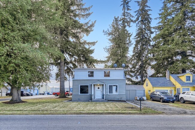
778 W Main St, Hillsboro, OR 97123

Property Detail
778 W Main St
R0765265
ACRES 0.16
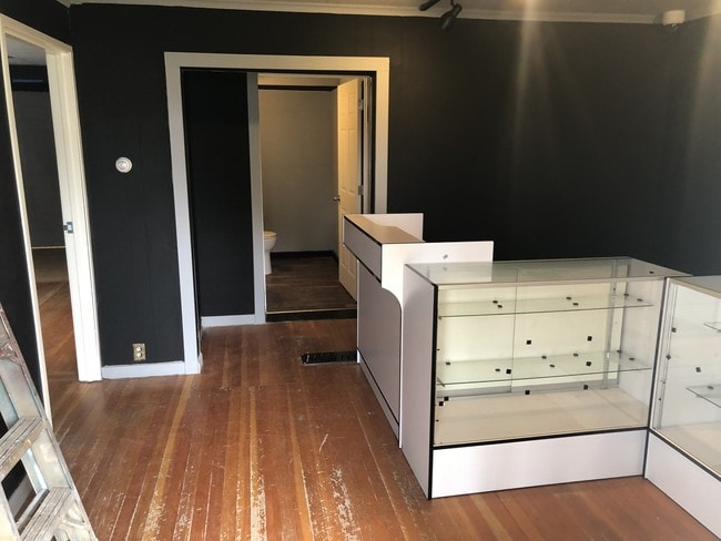
Commercialbuilding
Washington
I-G
Oregon
B and X Area of moderate flood hazard, usually the area between the limits of the 100-year and 500-year floods.
400
2024
0.16 AC
2026
Sunset Corridor/Hillsboro
032604
Portland
2,375 SF
Portland-Vancouver-Hillsboro, OR-WA
NEARBY LISTINGS FOR SALE OR LEASE
-
-
View all Hillsboro listings for sale on LoopNet.com
DEMOGRAPHICS near 778 W Main St
1 mile
3 mile
5 mile
2024 Total Population
8,177
59,070
118,554
2029 Population
8,188
59,246
119,610
Pop Growth 2024-2029
+ 0.13%
+ 0.30%
+ 0.89%
Average Age
39
38
38
2024 Total Households
2,815
19,520
41,780
HH Growth 2024-2029
+ 0.18%
+ 0.32%
+ 0.96%
Median Household Inc
$77,955
$84,029
$91,365
Avg Household Size
2.70
2.90
2.70
2024 Avg HH Vehicles
2.00
2.00
2.00
Median Home Value
$456,640
$431,192
$443,966
Median Year Built
1973
1982
1992
Nearby Places
Map Layers
Map Styles
 Street
 Aerial
Transit
 Traffic
 Biking
Places
Listings with unknown addresses are not visible on the map
- Restaurants
- Banks
- Shops
- Fitness
- Groceries
PUBLIC TRANSPORTATION
AIRPORT
Portland International
Drive
Walk
Distance
Portland International
52 min
30.4 mi
Freight Ports
Port of Portland
Drive
Walk
Distance
Port of Portland
35 min
19.4 mi
SALE & LEASE HISTORY
LISTING DATE
SALE/LEASE

Mar 18, 2018
For Lease
Jan 09, 2023
For Sale
Apr 10, 2018
For Sale
Nearby Properties
Address
Land Use
TOTAL SIZE
Lot Size
Zoning
Address
Land Use
TOTAL SIZE
Lot Size
Zoning
1,619,885 SF
115.71 AC
I-P
Address
Land Use
TOTAL SIZE
Lot Size
Zoning
9.97 AC
SCC-DT
Address
Land Use
TOTAL SIZE
Lot Size
Zoning
248,332 SF
4.26 AC
SCC-DT
Address
Land Use
TOTAL SIZE
Lot Size
Zoning
53.49 AC
SCFI
Address
Land Use
TOTAL SIZE
Lot Size
Zoning
256,652 SF
48.72 AC
SFR-7
Address
Land Use
TOTAL SIZE
Lot Size
Zoning
13,368 SF
112.70 AC
I-G
Address
Land Use
TOTAL SIZE
Lot Size
Zoning
82,297 SF
175.24 AC
I-G
Address
Land Use
TOTAL SIZE
Lot Size
Zoning
0.06 AC
I-P
Address
Land Use
TOTAL SIZE
Lot Size
Zoning
252,251 SF
2.62 AC
SCC-DT
Address
Land Use
TOTAL SIZE
Lot Size
Zoning
3,616 SF
0.85 AC
SCC-DT
Address
Land Use
TOTAL SIZE
Lot Size
Zoning
43,041 SF
9.43 AC
SFR-7
Address
Land Use
TOTAL SIZE
Lot Size
Zoning
240,000 SF
39.66 AC
SFR-7
Address
Land Use
TOTAL SIZE
Lot Size
Zoning
354,705 SF
18.29 AC
C-G
Address
Land Use
TOTAL SIZE
Lot Size
Zoning
180,900 SF
6.33 AC
SCR-HD
Address
Land Use
TOTAL SIZE
Lot Size
Zoning
347,362 SF
14.06 AC
C-G
Address
Land Use
TOTAL SIZE
Lot Size
Zoning
285,970 SF
1.58 AC
SCC-DT
Address
Land Use
TOTAL SIZE
Lot Size
Zoning
1.22 AC
I-G
Address
Land Use
TOTAL SIZE
Lot Size
Zoning
83,200 SF
17.96 AC
SFR-7
Address
Land Use
TOTAL SIZE
Lot Size
Zoning
9.47 AC
SFR-7
Address
Land Use
TOTAL SIZE
Lot Size
Zoning
187,850 SF
0.82 AC
SCC-DT
Address
Land Use
TOTAL SIZE
Lot Size
Zoning
59,800 SF
0.66 AC
SCC-DT
Address
Land Use
TOTAL SIZE
Lot Size
Zoning
20.62 AC
I-G
Address
Land Use
TOTAL SIZE
Lot Size
Zoning
2.83 AC
GMU
Address
Land Use
TOTAL SIZE
Lot Size
Zoning
72,500 SF
11.48 AC
SCR-MD
Address
Land Use
TOTAL SIZE
Lot Size
Zoning
169,980 SF
14 AC
GMU
Address
Land Use
TOTAL SIZE
Lot Size
Zoning
20.69 AC
SCFI
Address
Land Use
TOTAL SIZE
Lot Size
Zoning
9.52 AC
SFR-7
Address
Land Use
TOTAL SIZE
Lot Size
Zoning
25,505 SF
14.17 AC
SFR-7
Address
Land Use
TOTAL SIZE
Lot Size
Zoning
56,813 SF
10.02 AC
SFR-7
Address
Land Use
TOTAL SIZE
Lot Size
Zoning
49,163 SF
9.39 AC
SFR-7
The World's #1 Commercial Real Estate Marketplace
Connect with us
© 2026 CoStar Group
The information above has been obtained from sources believed reliable. While we do not doubt its accuracy we have not verified it and make no guarantee, warranty or representation about it. It is your responsibility to independently confirm its accuracy and completeness. Any projections, opinions, assumptions, or estimates used are for example only and do not represent the current or future performance of the property. The value of this transaction to you depends on tax and other factors which should be evaluated by your tax, financial, and legal advisors. You and your advisors should conduct a careful, independent investigation of the property to determine to your satisfaction the suitability of the property for your needs.