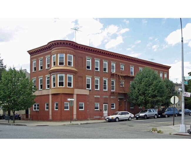
Property Record
78 E 4Th St, Brooklyn, NY 11218

Save to a Folder
{{folder.Name}}
{{folder.ListingIds.length}} Properties
{{folder.ListingIds.length}} Property
Create a New Folder
Property Detail
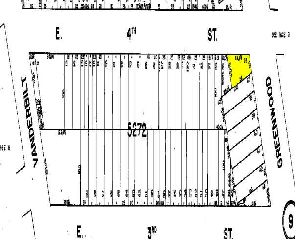
78 E 4Th St
05272-0036
DOCID-2020092900468003
Apartmenthouse5plusunits
Kings
R5
New York
B and X Area of moderate flood hazard, usually the area between the limits of the 100-year and 500-year floods.
36
2025
0.06 AC
2026
Windsor Terrace
150200
Long Island (New York)
5,175 SF
New York-Jersey City-White Plains, NY-NJ
NEARBY LISTINGS FOR SALE OR LEASE
DEMOGRAPHICS near 78 E 4Th St
1 mile
3 mile
5 mile
2025 Total Population
118,811
1,212,102
2,549,489
2030 Population
118,525
1,197,472
2,530,018
Pop Growth 2025-2030
(0.24%)
(1.21%)
(0.76%)
Average Age
39
39
39
2025 Total Households
42,599
438,259
944,061
HH Growth 2025-2030
(0.39%)
(1.29%)
(0.79%)
Median Household Inc
$99,013
$86,849
$81,371
Avg Household Size
2.60
2.60
2.60
2025 Avg HH Vehicles
1.00
1.00
1.00
Median Home Value
$1,026,507
$1,012,218
$921,587
Median Year Built
1947
1947
1948
Nearby Places
Map Layers
Map Styles
 Street
 Aerial
Layers
 Traffic
 Biking
Places
Listings with unknown addresses are not visible on the map
- Restaurants
- Banks
- Shops
- Fitness
- Groceries
PUBLIC TRANSPORTATION
TRANSIT/SUBWAY
Fort Hamilton Parkway (F,G Line) (F - New York MTA Subway (The Subway))
Drive
Walk
Distance
Fort Hamilton Parkway (F,G Line) (F - New York MTA Subway (The Subway))
2 min
5 min
0.3 mi
Church Avenue (F,G Line) (F - New York MTA Subway (The Subway))
Drive
Walk
Distance
Church Avenue (F,G Line) (F - New York MTA Subway (The Subway))
1 min
11 min
0.6 mi
15 Street-Prospect Park (F - New York MTA Subway (The Subway))
Drive
Walk
Distance
15 Street-Prospect Park (F - New York MTA Subway (The Subway))
3 min
16 min
0.9 mi
COMMUTER RAIL
Nostrand Avenue Station (Far Rockaway Branch - Long Island Rail Road, Hempstead Branch - Long Island Rail Road, Long Beach Branch - Long Island Rail Road, West Hempstead Branch - Long Island Rail Road)
Drive
Walk
Distance
Nostrand Avenue Station (Far Rockaway Branch - Long Island Rail Road, Hempstead Branch - Long Island Rail Road, Long Beach Branch - Long Island Rail Road, West Hempstead Branch - Long Island Rail Road)
10 min
3.7 mi
Atlantic Terminal (Babylon Branch - Long Island Rail Road, City Terminal Zone - Long Island Rail Road, Hempstead Branch - Long Island Rail Road, West Hempstead Branch - Long Island Rail Road)
Drive
Walk
Distance
Atlantic Terminal (Babylon Branch - Long Island Rail Road, City Terminal Zone - Long Island Rail Road, Hempstead Branch - Long Island Rail Road, West Hempstead Branch - Long Island Rail Road)
9 min
3.8 mi
AIRPORT
LaGuardia
Drive
Walk
Distance
LaGuardia
26 min
14.5 mi
Newark Liberty International
Drive
Walk
Distance
Newark Liberty International
30 min
17.9 mi
Freight Ports
NY - Red Hook Container Terminal
Drive
Walk
Distance
NY - Red Hook Container Terminal
6 min
3.3 mi
Nearby Properties
Address
Land Use
TOTAL SIZE
Lot Size
Zoning
Address
Land Use
TOTAL SIZE
Lot Size
Zoning
869,038 SF
1.53 AC
M1-1
Address
Land Use
TOTAL SIZE
Lot Size
Zoning
92,440 SF
466.23 AC
R5
Address
Land Use
TOTAL SIZE
Lot Size
Zoning
1,503,150 SF
20.47 AC
R5
Address
Land Use
TOTAL SIZE
Lot Size
Zoning
393.54 AC
PARK
Address
Land Use
TOTAL SIZE
Lot Size
Zoning
879,916 SF
1.35 AC
C6-4
Address
Land Use
TOTAL SIZE
Lot Size
Zoning
577,381 SF
3.19 AC
R6
Address
Land Use
TOTAL SIZE
Lot Size
Zoning
902,000 SF
3.21 AC
M3-1
Address
Land Use
TOTAL SIZE
Lot Size
Zoning
1,258,851 SF
2.20 AC
C6-4
Address
Land Use
TOTAL SIZE
Lot Size
Zoning
965,600 SF
6.65 AC
R5
Address
Land Use
TOTAL SIZE
Lot Size
Zoning
1,061,228 SF
8.86 AC
R5
Address
Land Use
TOTAL SIZE
Lot Size
Zoning
460,000 SF
3.21 AC
R6
Address
Land Use
TOTAL SIZE
Lot Size
Zoning
579,404 SF
4.80 AC
R6
Address
Land Use
TOTAL SIZE
Lot Size
Zoning
1,186,339 SF
0.99 AC
M14R72
Address
Land Use
TOTAL SIZE
Lot Size
Zoning
1,073,920 SF
16.53 AC
R6
Address
Land Use
TOTAL SIZE
Lot Size
Zoning
561,945 SF
11.58 AC
R6
Address
Land Use
TOTAL SIZE
Lot Size
Zoning
627,018 SF
1.21 AC
C6-4
Address
Land Use
TOTAL SIZE
Lot Size
Zoning
335,800 SF
1.51 AC
R6
Address
Land Use
TOTAL SIZE
Lot Size
Zoning
296,915 SF
0.31 AC
C5-3
Address
Land Use
TOTAL SIZE
Lot Size
Zoning
785,450 SF
14.22 AC
R6
Address
Land Use
TOTAL SIZE
Lot Size
Zoning
905,298 SF
1.60 AC
C61A
Address
Land Use
TOTAL SIZE
Lot Size
Zoning
1,324,592 SF
5.13 AC
M3-1
Address
Land Use
TOTAL SIZE
Lot Size
Zoning
565,326 SF
0.63 AC
C64.5
Address
Land Use
TOTAL SIZE
Lot Size
Zoning
397,354 SF
0.61 AC
C5-2
Address
Land Use
TOTAL SIZE
Lot Size
Zoning
566,000 SF
12.33 AC
R6
Address
Land Use
TOTAL SIZE
Lot Size
Zoning
600,000 SF
2.51 AC
R6B
Address
Land Use
TOTAL SIZE
Lot Size
Zoning
473,345 SF
1.27 AC
R8X
Address
Land Use
TOTAL SIZE
Lot Size
Zoning
389,125 SF
3.48 AC
C6-4
Address
Land Use
TOTAL SIZE
Lot Size
Zoning
489,344 SF
3.78 AC
C6-4
Address
Land Use
TOTAL SIZE
Lot Size
Zoning
710,746 SF
1.88 AC
C63A
Address
Land Use
TOTAL SIZE
Lot Size
Zoning
427,208 SF
1.30 AC
R6
The World's #1 Commercial Real Estate Marketplace
Connect with us
© 2026 CoStar Group
The information above has been obtained from sources believed reliable. While we do not doubt its accuracy we have not verified it and make no guarantee, warranty or representation about it. It is your responsibility to independently confirm its accuracy and completeness. Any projections, opinions, assumptions, or estimates used are for example only and do not represent the current or future performance of the property. The value of this transaction to you depends on tax and other factors which should be evaluated by your tax, financial, and legal advisors. You and your advisors should conduct a careful, independent investigation of the property to determine to your satisfaction the suitability of the property for your needs.