Property Record
78 N Dugger Ave, Roberta, GA 31078
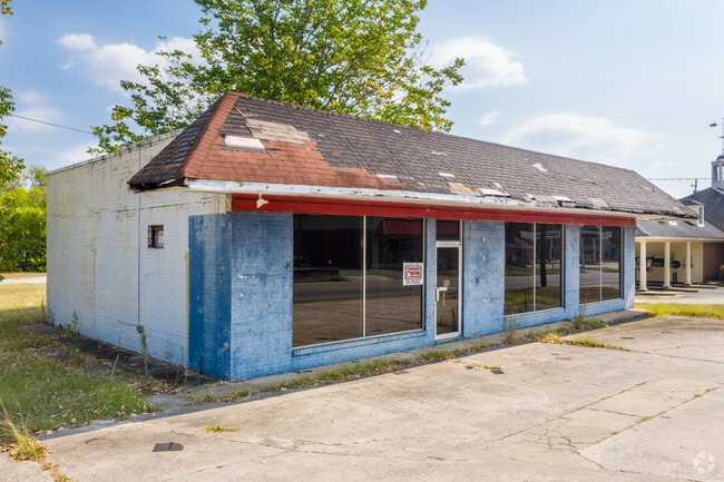

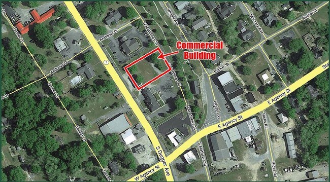
Property Detail
78 N Dugger Ave
C055A-202
EDWARDS INDUSTRIES
Storebuilding
CRAWFORD
C-2
Georgia
B and X Area of moderate flood hazard, usually the area between the limits of the 100-year and 500-year floods.
0.86 AC
2025
Crawford County
2025
Atlanta
070100
Macon-Bibb County, GA
1,604 SF
NEARBY LISTINGS FOR SALE OR LEASE
DEMOGRAPHICS near 78 N Dugger Ave
1 mile
3 mile
5 mile
2025 Total Population
963
2,189
4,065
2030 Population
979
2,233
4,161
Pop Growth 2025-2030
+ 1.66%
+ 2.01%
+ 2.36%
Average Age
45
45
44
2025 Total Households
400
893
1,607
HH Growth 2025-2030
+ 1.75%
+ 1.79%
+ 2.24%
Median Household Inc
$45,417
$48,287
$49,357
Avg Household Size
2.30
2.40
2.50
2025 Avg HH Vehicles
2.00
2.00
2.00
Median Home Value
$169,871
$184,459
$183,333
Median Year Built
1981
1984
1988
Nearby Places
Map Layers
Map Styles
 Street
 Aerial
Layers
 Traffic
 Biking
Places
Listings with unknown addresses are not visible on the map
- Restaurants
- Banks
- Shops
- Fitness
- Groceries
SALE & LEASE HISTORY
LISTING DATE
SALE/LEASE

Aug 27, 2019
For Lease
Aug 27, 2019
For Sale
Nearby Properties
Address
Land Use
TOTAL SIZE
Lot Size
Zoning
Address
Land Use
TOTAL SIZE
Lot Size
Zoning
222,214 SF
13.96 AC
R-1
Address
Land Use
TOTAL SIZE
Lot Size
Zoning
82,142 SF
24.40 AC
R-MH
Address
Land Use
TOTAL SIZE
Lot Size
Zoning
79,480 SF
23.37 AC
R-1
Address
Land Use
TOTAL SIZE
Lot Size
Zoning
23,814 SF
20.72 AC
IG
Address
Land Use
TOTAL SIZE
Lot Size
Zoning
16,128 SF
6.04 AC
R-4
Address
Land Use
TOTAL SIZE
Lot Size
Zoning
15,344 SF
3.83 AC
C-1
Address
Land Use
TOTAL SIZE
Lot Size
Zoning
1,671 SF
7.27 AC
R-3
Address
Land Use
TOTAL SIZE
Lot Size
Zoning
1,187.70 AC
R-AG
Address
Land Use
TOTAL SIZE
Lot Size
Zoning
32,052 SF
4.68 AC
R-2
Address
Land Use
TOTAL SIZE
Lot Size
Zoning
51,740 SF
12.93 AC
I-G
Address
Land Use
TOTAL SIZE
Lot Size
Zoning
30,262 SF
3.25 AC
R-1
Address
Land Use
TOTAL SIZE
Lot Size
Zoning
795 AC
R1-AG
Address
Land Use
TOTAL SIZE
Lot Size
Zoning
7,262 SF
0.93 AC
R-2
Address
Land Use
TOTAL SIZE
Lot Size
Zoning
30,636 SF
2.83 AC
C-2
Address
Land Use
TOTAL SIZE
Lot Size
Zoning
9,000 SF
5 AC
I-G
Address
Land Use
TOTAL SIZE
Lot Size
Zoning
5,432 SF
1.10 AC
R-2
Address
Land Use
TOTAL SIZE
Lot Size
Zoning
500 SF
8.09 AC
R-2
Address
Land Use
TOTAL SIZE
Lot Size
Zoning
8,847 SF
1.58 AC
R-1
Address
Land Use
TOTAL SIZE
Lot Size
Zoning
10,068 SF
2.52 AC
R-2
Address
Land Use
TOTAL SIZE
Lot Size
Zoning
13,782 SF
1.38 AC
R-2
Address
Land Use
TOTAL SIZE
Lot Size
Zoning
10,536 SF
1.84 AC
C-2
Address
Land Use
TOTAL SIZE
Lot Size
Zoning
65 AC
R-AG
Address
Land Use
TOTAL SIZE
Lot Size
Zoning
3,381 SF
1.39 AC
R-2
Address
Land Use
TOTAL SIZE
Lot Size
Zoning
60 AC
R-AG
Address
Land Use
TOTAL SIZE
Lot Size
Zoning
1.66 AC
C-2
Address
Land Use
TOTAL SIZE
Lot Size
Zoning
10,600 SF
1.99 AC
C-1
Address
Land Use
TOTAL SIZE
Lot Size
Zoning
1,210 SF
2.29 AC
C-2
Address
Land Use
TOTAL SIZE
Lot Size
Zoning
9,419 SF
1.11 AC
C-1
Address
Land Use
TOTAL SIZE
Lot Size
Zoning
6,784 SF
0.40 AC
R-1
Address
Land Use
TOTAL SIZE
Lot Size
Zoning
13,009 SF
C-2
The World's #1 Commercial Real Estate Marketplace
Connect with us
© 2026 CoStar Group
The information above has been obtained from sources believed reliable. While we do not doubt its accuracy we have not verified it and make no guarantee, warranty or representation about it. It is your responsibility to independently confirm its accuracy and completeness. Any projections, opinions, assumptions, or estimates used are for example only and do not represent the current or future performance of the property. The value of this transaction to you depends on tax and other factors which should be evaluated by your tax, financial, and legal advisors. You and your advisors should conduct a careful, independent investigation of the property to determine to your satisfaction the suitability of the property for your needs.