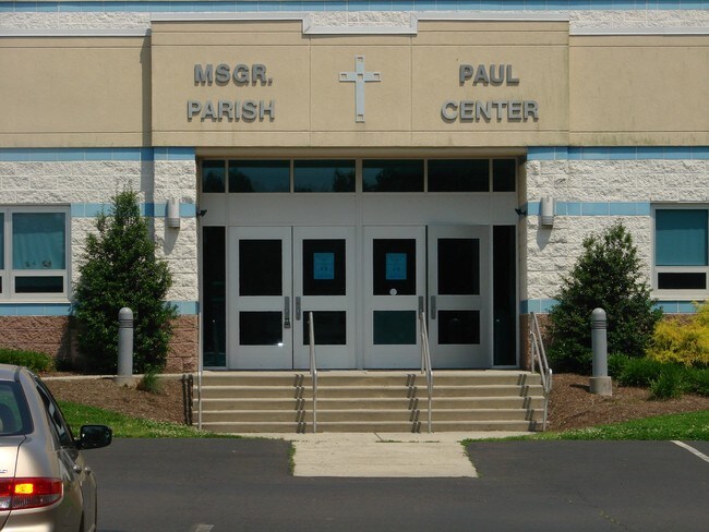
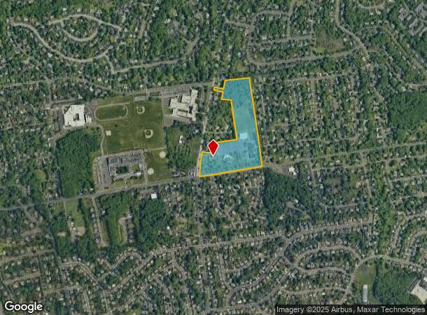
Property Record
782 Big Oak Rd, Morrisville, PA 19067
NEARBY LISTINGS FOR SALE OR LEASE
Property Detail
782 Big Oak Rd
20-041-080
1.0A LOT NE COR MAKEFIELD & BIG OAK RDS BROOKFIELD DR
Religious
Bucks
AE
Pennsylvania
42017C0454K
1 AC
2024
Lower Bucks County
2025
Philadelphia
105507
Philadelphia-Camden-Wilmington, PA-NJ-DE-MD
50,420 SF
DEMOGRAPHICS near 782 Big Oak Rd
1 Mile
3 Mile
5 Mile
2024 Total Population
11,269
81,273
253,212
2029 Population
11,176
81,017
250,823
Pop Growth 2024-2029
(0.83%)
(0.31%)
(0.94%)
Average Age
41
42
40
2024 Total Households
4,071
31,481
91,574
HH Growth 2024-2029
(0.91%)
(0.39%)
(0.95%)
Median Household Inc
$127,136
$90,813
$77,108
Avg Household Size
2.70
2.50
2.60
2024 Avg HH Vehicles
2.00
2.00
2.00
Median Home Value
$430,263
$347,617
$275,523
Median Year Built
1967
1959
1956
Nearby Places
Map Layers
Map Styles
 Street
 Aerial
- Restaurants
- Banks
- Shops
- Fitness
- Groceries
PUBLIC TRANSPORTATION
COMMUTER RAIL
Yardley (R3 - Southeastern Pennsylvania Transportation Authority Regional Rail (SEPTA Regional Rail))
DRIVE
WALK
Distance
Yardley (R3 - Southeastern Pennsylvania Transportation Authority Regional Rail (SEPTA Regional Rail))
5 min
2.1 mi
West Trenton (R3 - Southeastern Pennsylvania Transportation Authority Regional Rail (SEPTA Regional Rail))
DRIVE
WALK
Distance
West Trenton (R3 - Southeastern Pennsylvania Transportation Authority Regional Rail (SEPTA Regional Rail))
12 min
6.4 mi
AIRPORT
Trenton Mercer
DRIVE
WALK
Distance
Trenton Mercer
15 min
7.1 mi
Freight Ports
Port of Philadelphia
DRIVE
WALK
Distance
Port of Philadelphia
39 min
26.3 mi
Nearby Properties
Address
Land Use
TOTAL SIZE
Lot Size
Zoning
Address
Land Use
TOTAL SIZE
Lot Size
Zoning
8.23 AC
BA
Address
Land Use
TOTAL SIZE
Lot Size
Zoning
26 AC
HIST
Address
Land Use
TOTAL SIZE
Lot Size
Zoning
1,996 SF
125 AC
RA
Address
Land Use
TOTAL SIZE
Lot Size
Zoning
125,000 SF
3.68 AC
MU
Address
Land Use
TOTAL SIZE
Lot Size
Zoning
96.60 AC
OP-2
Address
Land Use
TOTAL SIZE
Lot Size
Zoning
0.24 AC
BA
Address
Land Use
TOTAL SIZE
Lot Size
Zoning
64.33 AC
R-2
Address
Land Use
TOTAL SIZE
Lot Size
Zoning
41,000 SF
0.91 AC
HIST
Address
Land Use
TOTAL SIZE
Lot Size
Zoning
8.46 AC
RA
Address
Land Use
TOTAL SIZE
Lot Size
Zoning
260,160 SF
0.84 AC
BA
Address
Land Use
TOTAL SIZE
Lot Size
Zoning
2.60 AC
BA
Address
Land Use
TOTAL SIZE
Lot Size
Zoning
7.25 AC
RB
Address
Land Use
TOTAL SIZE
Lot Size
Zoning
237,125 SF
0.77 AC
BA
Address
Land Use
TOTAL SIZE
Lot Size
Zoning
27.82 AC
R-M
Address
Land Use
TOTAL SIZE
Lot Size
Zoning
44.90 AC
R-2
Address
Land Use
TOTAL SIZE
Lot Size
Zoning
6,444 SF
44.01 AC
RA
Address
Land Use
TOTAL SIZE
Lot Size
Zoning
2.33 AC
HIST
Address
Land Use
TOTAL SIZE
Lot Size
Zoning
2.46 AC
RB
Address
Land Use
TOTAL SIZE
Lot Size
Zoning
6.44 AC
RB
Address
Land Use
TOTAL SIZE
Lot Size
Zoning
7.82 AC
Address
Land Use
TOTAL SIZE
Lot Size
Zoning
1.31 AC
RB
Address
Land Use
TOTAL SIZE
Lot Size
Zoning
11,380 SF
13.81 AC
Address
Land Use
TOTAL SIZE
Lot Size
Zoning
207,524 SF
1.01 AC
BA
Address
Land Use
TOTAL SIZE
Lot Size
Zoning
143,388 SF
2 AC
0000
Address
Land Use
TOTAL SIZE
Lot Size
Zoning
1.31 AC
RB
Address
Land Use
TOTAL SIZE
Lot Size
Zoning
81,624 SF
4.97 AC
MU
Address
Land Use
TOTAL SIZE
Lot Size
Zoning
3.31 AC
IA
Address
Land Use
TOTAL SIZE
Lot Size
Zoning
66,448 SF
0.81 AC
HIST
Address
Land Use
TOTAL SIZE
Lot Size
Zoning
178,770 SF
0.82 AC
HIST
Address
Land Use
TOTAL SIZE
Lot Size
Zoning
24,660 SF
0.09 AC
HIST
The World's #1 Commercial Real Estate Marketplace
Connect with us
© 2026 CoStar Group
The information above has been obtained from sources believed reliable. While we do not doubt its accuracy we have not verified it and make no guarantee, warranty or representation about it. It is your responsibility to independently confirm its accuracy and completeness. Any projections, opinions, assumptions, or estimates used are for example only and do not represent the current or future performance of the property. The value of this transaction to you depends on tax and other factors which should be evaluated by your tax, financial, and legal advisors. You and your advisors should conduct a careful, independent investigation of the property to determine to your satisfaction the suitability of the property for your needs.