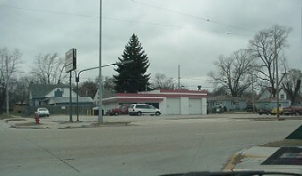
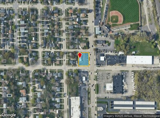
Property Record
7850 Sheridan Rd, Kenosha, WI 53143
NEARBY LISTINGS FOR SALE OR LEASE
Property Detail
7850 Sheridan Rd
Chicago-Naperville-Elgin, IL-IN-WI
Kirchner H
06-123-07-287-001
15207 15208 LOTS 1 2 & 3 KIRCHNER HIGHLANDS SUB PT OF NW 1/4 SEC7 T 1 R 23 DOC#1184785 DOC#1228792 DOC#1494345 DOC#1963876 LC
Commercialnec
Kenosha
X
Wisconsin
55059C0212E
1
2024
0.38 AC
2024
Kenosha East
002200
Chicago
1,580 SF
DEMOGRAPHICS near 7850 Sheridan Rd
1 Mile
3 Mile
5 Mile
2024 Total Population
13,239
69,571
107,483
2029 Population
13,037
68,471
106,412
Pop Growth 2024-2029
(1.53%)
(1.58%)
(1.00%)
Average Age
39
39
40
2024 Total Households
5,273
27,399
42,746
HH Growth 2024-2029
(1.52%)
(1.62%)
(0.97%)
Median Household Inc
$67,222
$62,560
$66,470
Avg Household Size
2.40
2.40
2.40
2024 Avg HH Vehicles
2.00
2.00
2.00
Median Home Value
$163,162
$185,157
$207,525
Median Year Built
1954
1960
1969
Nearby Places
Map Layers
Map Styles
 Street
 Aerial
- Restaurants
- Banks
- Shops
- Fitness
- Groceries
PUBLIC TRANSPORTATION
COMMUTER RAIL
Kenosha Station (Union Pacific North Line - Northeast Illinois Regional Commuter Railroad (Metra))
DRIVE
WALK
Distance
Kenosha Station (Union Pacific North Line - Northeast Illinois Regional Commuter Railroad (Metra))
4 min
2.0 mi
Winthrop Harbor Station (Union Pacific North Line - Northeast Illinois Regional Commuter Railroad (Metra))
DRIVE
WALK
Distance
Winthrop Harbor Station (Union Pacific North Line - Northeast Illinois Regional Commuter Railroad (Metra))
11 min
5.8 mi
AIRPORT
General Mitchell International
DRIVE
WALK
Distance
General Mitchell International
47 min
34.9 mi
Freight Ports
Port Milwaukee
DRIVE
WALK
Distance
Port Milwaukee
52 min
38.8 mi
Nearby Properties
Address
Land Use
TOTAL SIZE
Lot Size
Zoning
Address
Land Use
TOTAL SIZE
Lot Size
Zoning
10.37 AC
IP
Address
Land Use
TOTAL SIZE
Lot Size
Zoning
357,885 SF
26.58 AC
M1
Address
Land Use
TOTAL SIZE
Lot Size
Zoning
76,848 SF
8.09 AC
BASE
Address
Land Use
TOTAL SIZE
Lot Size
Zoning
28,815 SF
1.04 AC
B3
Address
Land Use
TOTAL SIZE
Lot Size
Zoning
17,174 SF
10.31 AC
RS2
Address
Land Use
TOTAL SIZE
Lot Size
Zoning
0.62 AC
Address
Land Use
TOTAL SIZE
Lot Size
Zoning
67,850 SF
5.51 AC
B2
Address
Land Use
TOTAL SIZE
Lot Size
Zoning
63,500 SF
5.81 AC
RM2
Address
Land Use
TOTAL SIZE
Lot Size
Zoning
147,040 SF
2.50 AC
RM2
Address
Land Use
TOTAL SIZE
Lot Size
Zoning
92,358 SF
8.72 AC
B2
Address
Land Use
TOTAL SIZE
Lot Size
Zoning
39.98 AC
BASE
Address
Land Use
TOTAL SIZE
Lot Size
Zoning
71,277 SF
14.28 AC
B2
Address
Land Use
TOTAL SIZE
Lot Size
Zoning
1,200 SF
17.69 AC
Address
Land Use
TOTAL SIZE
Lot Size
Zoning
60,657 SF
4.42 AC
RM3
Address
Land Use
TOTAL SIZE
Lot Size
Zoning
61,318 SF
6.17 AC
B2
Address
Land Use
TOTAL SIZE
Lot Size
Zoning
88,867 SF
8.32 AC
B2
Address
Land Use
TOTAL SIZE
Lot Size
Zoning
116,227 SF
10.60 AC
B2
Address
Land Use
TOTAL SIZE
Lot Size
Zoning
21,060 SF
7.02 AC
RM2
Address
Land Use
TOTAL SIZE
Lot Size
Zoning
21,060 SF
7.08 AC
RM2
Address
Land Use
TOTAL SIZE
Lot Size
Zoning
6.03 AC
M2
Address
Land Use
TOTAL SIZE
Lot Size
Zoning
25,164 SF
3.21 AC
RM2
Address
Land Use
TOTAL SIZE
Lot Size
Zoning
89,436 SF
4.53 AC
RM2
Address
Land Use
TOTAL SIZE
Lot Size
Zoning
20,264 SF
5.73 AC
RM2
Address
Land Use
TOTAL SIZE
Lot Size
Zoning
44,566 SF
3.51 AC
IP
Address
Land Use
TOTAL SIZE
Lot Size
Zoning
1.30 AC
B3
Address
Land Use
TOTAL SIZE
Lot Size
Zoning
56,008 SF
5.77 AC
B4
Address
Land Use
TOTAL SIZE
Lot Size
Zoning
0.41 AC
B4
Address
Land Use
TOTAL SIZE
Lot Size
Zoning
58,410 SF
4.84 AC
Address
Land Use
TOTAL SIZE
Lot Size
Zoning
69,233 SF
2.18 AC
FW
Address
Land Use
TOTAL SIZE
Lot Size
Zoning
5,200 SF
7.64 AC
B2
The World's #1 Commercial Real Estate Marketplace
Connect with us
© 2025 CoStar Group
The information above has been obtained from sources believed reliable. While we do not doubt its accuracy we have not verified it and make no guarantee, warranty or representation about it. It is your responsibility to independently confirm its accuracy and completeness. Any projections, opinions, assumptions, or estimates used are for example only and do not represent the current or future performance of the property. The value of this transaction to you depends on tax and other factors which should be evaluated by your tax, financial, and legal advisors. You and your advisors should conduct a careful, independent investigation of the property to determine to your satisfaction the suitability of the property for your needs.