Property Record
7863 W 38Th Ave, Wheat Ridge, CO 80033
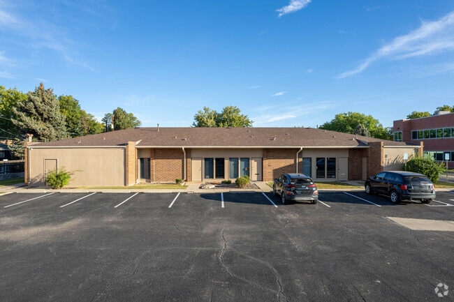
This Property Is For Sale
NEARBY LISTINGS FOR SALE OR LEASE
Property Detail
7863 W 38Th Ave
39-233-21-022
Zephyr Medical Commons Ph Ii Condo
Commercialcondominium
SECTION 23 TOWNSHIP 03 RANGE 69 QTR SW SUBDIVISIONCD 860800 SUBDIVISIONNAME ZEPHYR MEDICAL COMMONS PH II CONDO BLOCK LOT SIZE: 51920 TRACT 0CA VALUE: 1.192
X
Jefferson
08059C0214G
Colorado
0
0.02 AC
2024
West Denver
010502
Denver
940 SF
Denver-Aurora-Centennial, CO
DEMOGRAPHICS near 7863 W 38Th Ave
1 mile
3 mile
5 mile
2024 Total Population
12,318
129,820
353,863
2029 Population
12,339
129,805
355,928
Pop Growth 2024-2029
+ 0.17%
(0.01%)
+ 0.58%
Average Age
44
40
39
2024 Total Households
5,713
58,961
155,609
HH Growth 2024-2029
+ 0.18%
(0.10%)
+ 0.65%
Median Household Inc
$74,624
$77,422
$81,905
Avg Household Size
2.10
2.10
2.20
2024 Avg HH Vehicles
2.00
2.00
2.00
Median Home Value
$558,424
$579,080
$555,857
Median Year Built
1962
1966
1972
Nearby Places
Map Layers
Map Styles
 Street
 Aerial
Transit
 Traffic
 Biking
Places
Listings with unknown addresses are not visible on the map
- Restaurants
- Banks
- Shops
- Fitness
- Groceries
PUBLIC TRANSPORTATION
COMMUTER RAIL
Olde Town Arvada W-Bound (Union Station to Wheat Ridge Ward Station - Regional Transportation District)
Drive
Walk
Distance
Olde Town Arvada W-Bound (Union Station to Wheat Ridge Ward Station - Regional Transportation District)
5 min
2.4 mi
Olde Town Arvada E-Bound (Union Station to Wheat Ridge Ward Station - Regional Transportation District)
Drive
Walk
Distance
Olde Town Arvada E-Bound (Union Station to Wheat Ridge Ward Station - Regional Transportation District)
6 min
2.5 mi
AIRPORT
Denver International
Drive
Walk
Distance
Denver International
37 min
28.5 mi
Freight Ports
Tulsa Port Of Catoosa
Drive
Walk
Distance
Tulsa Port Of Catoosa
734 min
714.0 mi
Nearby Properties
Address
Land Use
TOTAL SIZE
Lot Size
Zoning
Address
Land Use
TOTAL SIZE
Lot Size
Zoning
251,587 SF
2.58 AC
C-MX-5
Address
Land Use
TOTAL SIZE
Lot Size
Zoning
310,267 SF
1.69 AC
C-MX
Address
Land Use
TOTAL SIZE
Lot Size
Zoning
104,837 SF
0.72 AC
U-MS
Address
Land Use
TOTAL SIZE
Lot Size
Zoning
30,316 SF
0.85 AC
U-MS
Address
Land Use
TOTAL SIZE
Lot Size
Zoning
50,372 SF
0.30 AC
U-MS
Address
Land Use
TOTAL SIZE
Lot Size
Zoning
102,182 SF
3.70 AC
CMP
Address
Land Use
TOTAL SIZE
Lot Size
Zoning
111,673 SF
29.06 AC
Address
Land Use
TOTAL SIZE
Lot Size
Zoning
298,150 SF
24.21 AC
Address
Land Use
TOTAL SIZE
Lot Size
Zoning
187,095 SF
23.42 AC
Address
Land Use
TOTAL SIZE
Lot Size
Zoning
187,745 SF
16.25 AC
Address
Land Use
TOTAL SIZE
Lot Size
Zoning
27,921 SF
0.29 AC
C-MX-5
Address
Land Use
TOTAL SIZE
Lot Size
Zoning
436,238 SF
13.94 AC
Address
Land Use
TOTAL SIZE
Lot Size
Zoning
30,934 SF
0.31 AC
U-MS
Address
Land Use
TOTAL SIZE
Lot Size
Zoning
247,459 SF
2.31 AC
C-MX-8
Address
Land Use
TOTAL SIZE
Lot Size
Zoning
167,420 SF
5.84 AC
Address
Land Use
TOTAL SIZE
Lot Size
Zoning
142,635 SF
6.84 AC
U-SU-B1
Address
Land Use
TOTAL SIZE
Lot Size
Zoning
389,561 SF
10.73 AC
Address
Land Use
TOTAL SIZE
Lot Size
Zoning
212,995 SF
3.20 AC
R-3
Address
Land Use
TOTAL SIZE
Lot Size
Zoning
100,615 SF
2.28 AC
Address
Land Use
TOTAL SIZE
Lot Size
Zoning
131,135 SF
2.83 AC
Address
Land Use
TOTAL SIZE
Lot Size
Zoning
262,699 SF
13.10 AC
A2
Address
Land Use
TOTAL SIZE
Lot Size
Zoning
311,200 SF
0.85 AC
Address
Land Use
TOTAL SIZE
Lot Size
Zoning
138,204 SF
3.68 AC
Address
Land Use
TOTAL SIZE
Lot Size
Zoning
111,478 SF
8.24 AC
CMP
Address
Land Use
TOTAL SIZE
Lot Size
Zoning
330,357 SF
15.16 AC
Address
Land Use
TOTAL SIZE
Lot Size
Zoning
76,078 SF
6.64 AC
U-SU-C
Address
Land Use
TOTAL SIZE
Lot Size
Zoning
241,243 SF
9.08 AC
Address
Land Use
TOTAL SIZE
Lot Size
Zoning
87,567 SF
14.98 AC
R-5
Address
Land Use
TOTAL SIZE
Lot Size
Zoning
1,517 SF
1.18 AC
U-MX-3
Address
Land Use
TOTAL SIZE
Lot Size
Zoning
115,719 SF
5.93 AC
The World's #1 Commercial Real Estate Marketplace
Connect with us
© 2026 CoStar Group
The information above has been obtained from sources believed reliable. While we do not doubt its accuracy we have not verified it and make no guarantee, warranty or representation about it. It is your responsibility to independently confirm its accuracy and completeness. Any projections, opinions, assumptions, or estimates used are for example only and do not represent the current or future performance of the property. The value of this transaction to you depends on tax and other factors which should be evaluated by your tax, financial, and legal advisors. You and your advisors should conduct a careful, independent investigation of the property to determine to your satisfaction the suitability of the property for your needs.