Property Record
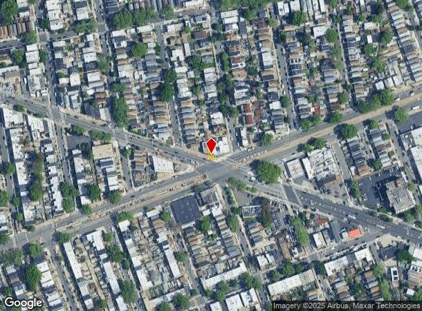
7911 Rockaway Blvd, Woodhaven, NY 11421
NEARBY LISTINGS FOR SALE OR LEASE
Property Detail
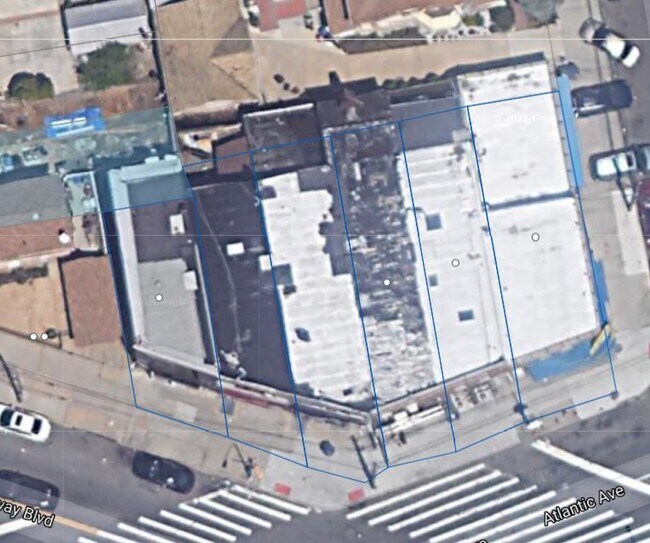
7911 Rockaway Blvd
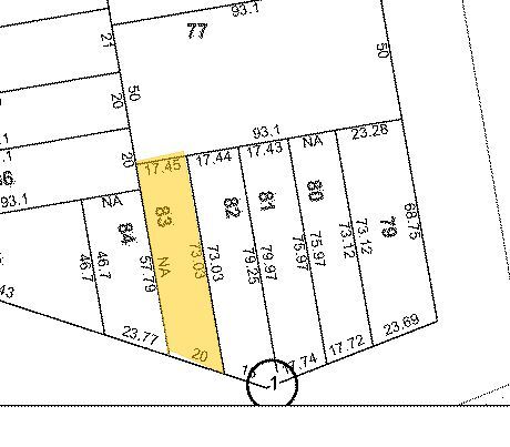
08959-0083
Queens 04 Ward
Commercialofficeresidentialmixeduse
Queens
X
New York
3604970236F
83
2024
0.03 AC
2025
Central Queens
000600
Long Island (New York)
1,700 SF
New York-Jersey City-White Plains, NY-NJ
DEMOGRAPHICS near 7911 Rockaway Blvd
1 Mile
3 Mile
5 Mile
2024 Total Population
97,180
714,261
2,050,658
2029 Population
86,918
658,575
1,906,646
Pop Growth 2024-2029
(10.56%)
(7.80%)
(7.02%)
Average Age
38
40
40
2024 Total Households
27,871
248,677
712,757
HH Growth 2024-2029
(11.24%)
(7.96%)
(7.28%)
Median Household Inc
$67,614
$67,068
$65,212
Avg Household Size
3.30
2.70
2.70
2024 Avg HH Vehicles
1.00
1.00
1.00
Median Home Value
$705,500
$683,615
$684,186
Median Year Built
1947
1949
1950
Nearby Places
- Restaurants
- Banks
- Shops
- Fitness
- Groceries
PUBLIC TRANSPORTATION
TRANSIT/SUBWAY
80 Street (A - New York MTA Subway (The Subway))
DRIVE
WALK
Distance
80 Street (A - New York MTA Subway (The Subway))
2 min
9 min
0.4 mi
75 Street-Elderts Lane (J - New York MTA Subway (The Subway), Z - New York MTA Subway (The Subway))
DRIVE
WALK
Distance
75 Street-Elderts Lane (J - New York MTA Subway (The Subway), Z - New York MTA Subway (The Subway))
2 min
12 min
0.6 mi
85 Street-Forest Parkway (J - New York MTA Subway (The Subway))
DRIVE
WALK
Distance
85 Street-Forest Parkway (J - New York MTA Subway (The Subway))
2 min
12 min
0.6 mi
88 Street (A - New York MTA Subway (The Subway))
DRIVE
WALK
Distance
88 Street (A - New York MTA Subway (The Subway))
2 min
13 min
0.7 mi
Grant Avenue (A - New York MTA Subway (The Subway))
DRIVE
WALK
Distance
Grant Avenue (A - New York MTA Subway (The Subway))
3 min
15 min
0.8 mi
COMMUTER RAIL
Kew Gardens Station (Babylon Branch - Long Island Rail Road, Hempstead Branch - Long Island Rail Road, Long Beach Branch - Long Island Rail Road, Port Jefferson Branch - Long Island Rail Road)
DRIVE
WALK
Distance
Kew Gardens Station (Babylon Branch - Long Island Rail Road, Hempstead Branch - Long Island Rail Road, Long Beach Branch - Long Island Rail Road, Port Jefferson Branch - Long Island Rail Road)
7 min
3.0 mi
East New York Station (Far Rockaway Branch - Long Island Rail Road, Long Beach Branch - Long Island Rail Road, West Hempstead Branch - Long Island Rail Road)
DRIVE
WALK
Distance
East New York Station (Far Rockaway Branch - Long Island Rail Road, Long Beach Branch - Long Island Rail Road, West Hempstead Branch - Long Island Rail Road)
7 min
3.2 mi
AIRPORT
John F Kennedy International
DRIVE
WALK
Distance
John F Kennedy International
13 min
6.6 mi
LaGuardia
DRIVE
WALK
Distance
LaGuardia
18 min
9.4 mi
Newark Liberty International
DRIVE
WALK
Distance
Newark Liberty International
40 min
21.0 mi
Freight Ports
NY - Red Hook Container Terminal
DRIVE
WALK
Distance
NY - Red Hook Container Terminal
23 min
9.6 mi
Nearby Properties
Address
Land Use
TOTAL SIZE
Lot Size
Zoning
Address
Land Use
TOTAL SIZE
Lot Size
Zoning
1,845,252 SF
172 AC
C8-1
Address
Land Use
TOTAL SIZE
Lot Size
Zoning
54,170 SF
229.57 AC
PARK
Address
Land Use
TOTAL SIZE
Lot Size
Zoning
1,688,760 SF
24.65 AC
R5
Address
Land Use
TOTAL SIZE
Lot Size
Zoning
1,516,458 SF
5.97 AC
R7-1
Address
Land Use
TOTAL SIZE
Lot Size
Zoning
532,011 SF
2.48 AC
R6
Address
Land Use
TOTAL SIZE
Lot Size
Zoning
600 SF
33.07 AC
PARK
Address
Land Use
TOTAL SIZE
Lot Size
Zoning
126.85 AC
PARK
Address
Land Use
TOTAL SIZE
Lot Size
Zoning
24,400 SF
33.98 AC
C4-2
Address
Land Use
TOTAL SIZE
Lot Size
Zoning
1,000 SF
210.07 AC
R3-2
Address
Land Use
TOTAL SIZE
Lot Size
Zoning
1,572,198 SF
22.06 AC
M1-2
Address
Land Use
TOTAL SIZE
Lot Size
Zoning
1,493,793 SF
14.19 AC
R5
Address
Land Use
TOTAL SIZE
Lot Size
Zoning
1,420,000 SF
19.61 AC
R5
Address
Land Use
TOTAL SIZE
Lot Size
Zoning
344,116 SF
0.92 AC
R7-1
Address
Land Use
TOTAL SIZE
Lot Size
Zoning
363,548 SF
1.81 AC
Address
Land Use
TOTAL SIZE
Lot Size
Zoning
2,193 SF
94.72 AC
PARK
Address
Land Use
TOTAL SIZE
Lot Size
Zoning
307,038 SF
7.84 AC
M1-1
Address
Land Use
TOTAL SIZE
Lot Size
Zoning
28.64 AC
PARK
Address
Land Use
TOTAL SIZE
Lot Size
Zoning
474,715 SF
1.72 AC
M14R8A
Address
Land Use
TOTAL SIZE
Lot Size
Zoning
490,600 SF
12.01 AC
M1-1
Address
Land Use
TOTAL SIZE
Lot Size
Zoning
1,136,208 SF
30.25 AC
R5
Address
Land Use
TOTAL SIZE
Lot Size
Zoning
997,720 SF
8.23 AC
R5
Address
Land Use
TOTAL SIZE
Lot Size
Zoning
158,402 SF
3.64 AC
C4-2
Address
Land Use
TOTAL SIZE
Lot Size
Zoning
230,580 SF
3.41 AC
C8-1
Address
Land Use
TOTAL SIZE
Lot Size
Zoning
940,800 SF
11.55 AC
R5
Address
Land Use
TOTAL SIZE
Lot Size
Zoning
203,132 SF
3.09 AC
C4-2
Address
Land Use
TOTAL SIZE
Lot Size
Zoning
1,622,073 SF
10.69 AC
R6
Address
Land Use
TOTAL SIZE
Lot Size
Zoning
29.68 AC
C4-2
Address
Land Use
TOTAL SIZE
Lot Size
Zoning
4,279,575 SF
144.16 AC
PARK
Address
Land Use
TOTAL SIZE
Lot Size
Zoning
107,000 SF
1.84 AC
R6
Address
Land Use
TOTAL SIZE
Lot Size
Zoning
348,320 SF
6.79 AC
C4-4
The World's #1 Commercial Real Estate Marketplace
Connect with us
© 2025 CoStar Group
The information above has been obtained from sources believed reliable. While we do not doubt its accuracy we have not verified it and make no guarantee, warranty or representation about it. It is your responsibility to independently confirm its accuracy and completeness. Any projections, opinions, assumptions, or estimates used are for example only and do not represent the current or future performance of the property. The value of this transaction to you depends on tax and other factors which should be evaluated by your tax, financial, and legal advisors. You and your advisors should conduct a careful, independent investigation of the property to determine to your satisfaction the suitability of the property for your needs.