Property Record
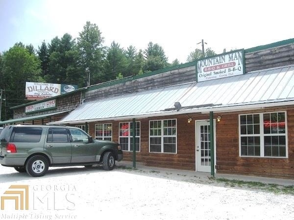
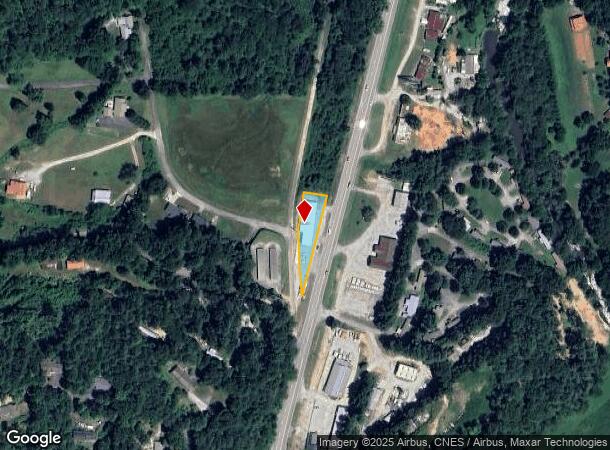
7923 Highway 441 N, Dillard, GA 30537

This Property Is For Sale
NEARBY LISTINGS FOR SALE OR LEASE
Property Detail
7923 Highway 441 N
047A-008
LOT B LANDLOT: 190 LANDDIST: 2
Commercialnec
Rabun
X
Georgia
13241C0107D
b
2025
0.37 AC
2025
Georgia Northeast
970101
Other Market Areas
5,484 SF
DEMOGRAPHICS near 7923 Highway 441 N
1 Mile
3 Mile
5 Mile
2024 Total Population
610
2,457
5,852
2029 Population
637
2,591
6,167
Pop Growth 2024-2029
+ 4.43%
+ 5.45%
+ 5.38%
Average Age
45
46
47
2024 Total Households
251
1,050
2,539
HH Growth 2024-2029
+ 4.38%
+ 5.33%
+ 5.32%
Median Household Inc
$56,874
$56,637
$55,825
Avg Household Size
2.40
2.30
2.30
2024 Avg HH Vehicles
2.00
2.00
2.00
Median Home Value
$221,875
$234,079
$234,977
Median Year Built
1985
1987
1986
Nearby Places
Map Layers
Map Styles
 Street
 Aerial
- Restaurants
- Banks
- Shops
- Fitness
- Groceries
Nearby Properties
Address
Land Use
TOTAL SIZE
Lot Size
Zoning
Address
Land Use
TOTAL SIZE
Lot Size
Zoning
977,485 SF
85.55 AC
M1
Address
Land Use
TOTAL SIZE
Lot Size
Zoning
3,524 SF
2.67 AC
Address
Land Use
TOTAL SIZE
Lot Size
Zoning
1,344 SF
56.29 AC
Address
Land Use
TOTAL SIZE
Lot Size
Zoning
Address
Land Use
TOTAL SIZE
Lot Size
Zoning
8,820 SF
60.34 AC
CB
Address
Land Use
TOTAL SIZE
Lot Size
Zoning
31,098 SF
2.17 AC
HB
Address
Land Use
TOTAL SIZE
Lot Size
Zoning
314.37 AC
A
Address
Land Use
TOTAL SIZE
Lot Size
Zoning
4,800 SF
3.55 AC
C
Address
Land Use
TOTAL SIZE
Lot Size
Zoning
3,000 SF
4.07 AC
R
Address
Land Use
TOTAL SIZE
Lot Size
Zoning
34,424 SF
11.98 AC
A
Address
Land Use
TOTAL SIZE
Lot Size
Zoning
111.71 AC
R
Address
Land Use
TOTAL SIZE
Lot Size
Zoning
4.86 AC
Address
Land Use
TOTAL SIZE
Lot Size
Zoning
7,470 SF
1.26 AC
Address
Land Use
TOTAL SIZE
Lot Size
Zoning
85.31 AC
A
Address
Land Use
TOTAL SIZE
Lot Size
Zoning
18,800 SF
1.07 AC
CB
Address
Land Use
TOTAL SIZE
Lot Size
Zoning
15,428 SF
2.66 AC
CB
Address
Land Use
TOTAL SIZE
Lot Size
Zoning
15.28 AC
R
Address
Land Use
TOTAL SIZE
Lot Size
Zoning
16,750 SF
1.93 AC
HB
Address
Land Use
TOTAL SIZE
Lot Size
Zoning
24.51 AC
Address
Land Use
TOTAL SIZE
Lot Size
Zoning
8,289 SF
0.74 AC
CB
Address
Land Use
TOTAL SIZE
Lot Size
Zoning
69.11 AC
M1
Address
Land Use
TOTAL SIZE
Lot Size
Zoning
2,280 SF
1.37 AC
C
Address
Land Use
TOTAL SIZE
Lot Size
Zoning
89.64 AC
A
Address
Land Use
TOTAL SIZE
Lot Size
Zoning
34.52 AC
R
Address
Land Use
TOTAL SIZE
Lot Size
Zoning
977,485 SF
4.64 AC
M1
Address
Land Use
TOTAL SIZE
Lot Size
Zoning
29 AC
R
Address
Land Use
TOTAL SIZE
Lot Size
Zoning
7,552 SF
3.46 AC
CB
Address
Land Use
TOTAL SIZE
Lot Size
Zoning
1,080 SF
1.72 AC
EX
Address
Land Use
TOTAL SIZE
Lot Size
Zoning
20,605 SF
3.52 AC
CB
Address
Land Use
TOTAL SIZE
Lot Size
Zoning
20.01 AC
The World's #1 Commercial Real Estate Marketplace
Connect with us
© 2026 CoStar Group
The information above has been obtained from sources believed reliable. While we do not doubt its accuracy we have not verified it and make no guarantee, warranty or representation about it. It is your responsibility to independently confirm its accuracy and completeness. Any projections, opinions, assumptions, or estimates used are for example only and do not represent the current or future performance of the property. The value of this transaction to you depends on tax and other factors which should be evaluated by your tax, financial, and legal advisors. You and your advisors should conduct a careful, independent investigation of the property to determine to your satisfaction the suitability of the property for your needs.