Property Record
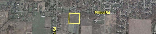
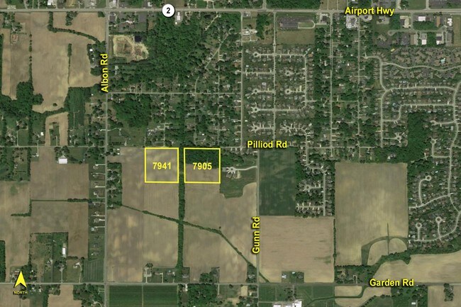
7941 Pilliod Rd, Maumee, OH 43537
Property Detail
7941 Pilliod Rd
65-22382
2 20 SW 1/4 NLY 822.78 FT AS MEAS ON WLINE THT PT E 1/4 OF
Agriculturalland
LUCAS
19-MX
Ohio
B and X Area of moderate flood hazard, usually the area between the limits of the 100-year and 500-year floods.
11.67 AC
0
South/Southwest
2025
Toledo
007104
Toledo, OH
NEARBY LISTINGS FOR SALE OR LEASE
DEMOGRAPHICS near 7941 Pilliod Rd
1 mile
3 mile
5 mile
2025 Total Population
2,975
31,263
88,717
2030 Population
2,917
30,759
87,701
Pop Growth 2025-2030
(1.95%)
(1.61%)
(1.15%)
Average Age
43
43
42
2025 Total Households
1,190
12,643
38,432
HH Growth 2025-2030
(2.10%)
(1.53%)
(1.09%)
Median Household Inc
$109,760
$92,893
$76,972
Avg Household Size
2.40
2.40
2.20
2025 Avg HH Vehicles
2.00
2.00
2.00
Median Home Value
$307,738
$302,266
$254,703
Median Year Built
1992
1988
1982
Nearby Places
Map Layers
Map Styles
 Street
 Aerial
Transit
 Traffic
 Biking
Places
Listings with unknown addresses are not visible on the map
- Restaurants
- Banks
- Shops
- Fitness
- Groceries
PUBLIC TRANSPORTATION
AIRPORT
Eugene F Kranz Toledo Express
Drive
Walk
Distance
Eugene F Kranz Toledo Express
21 min
9.1 mi
Freight Ports
Port of Toledo
Drive
Walk
Distance
Port of Toledo
33 min
16.9 mi
SALE & LEASE HISTORY
LISTING DATE
SALE/LEASE

Dec 06, 2016
For Sale
Nearby Properties
Address
Land Use
TOTAL SIZE
Lot Size
Zoning
Address
Land Use
TOTAL SIZE
Lot Size
Zoning
186,190 SF
14 AC
19-C2
Address
Land Use
TOTAL SIZE
Lot Size
Zoning
35.94 AC
17-C3
Address
Land Use
TOTAL SIZE
Lot Size
Zoning
211,140 SF
28.92 AC
10-IC
Address
Land Use
TOTAL SIZE
Lot Size
Zoning
372,117 SF
35 AC
17-AR
Address
Land Use
TOTAL SIZE
Lot Size
Zoning
178,915 SF
13 AC
19-R3
Address
Land Use
TOTAL SIZE
Lot Size
Zoning
212,664 SF
21.43 AC
24-B3
Address
Land Use
TOTAL SIZE
Lot Size
Zoning
139,741 SF
30.48 AC
19-RA3
Address
Land Use
TOTAL SIZE
Lot Size
Zoning
203,839 SF
16.39 AC
24-SUP
Address
Land Use
TOTAL SIZE
Lot Size
Zoning
350,408 SF
20.83 AC
17-M2
Address
Land Use
TOTAL SIZE
Lot Size
Zoning
1,176 SF
626.54 AC
17-AR
Address
Land Use
TOTAL SIZE
Lot Size
Zoning
156,420 SF
12 AC
19-R3
Address
Land Use
TOTAL SIZE
Lot Size
Zoning
238,148 SF
18.20 AC
24-B3
Address
Land Use
TOTAL SIZE
Lot Size
Zoning
214,986 SF
17.55 AC
19-R1
Address
Land Use
TOTAL SIZE
Lot Size
Zoning
111,195 SF
13.64 AC
19-C2
Address
Land Use
TOTAL SIZE
Lot Size
Zoning
120,077 SF
9.53 AC
24-B3
Address
Land Use
TOTAL SIZE
Lot Size
Zoning
86,450 SF
6.33 AC
17-R3
Address
Land Use
TOTAL SIZE
Lot Size
Zoning
103,406 SF
7.55 AC
24-SUP
Address
Land Use
TOTAL SIZE
Lot Size
Zoning
76,698 SF
7.70 AC
19-C2
Address
Land Use
TOTAL SIZE
Lot Size
Zoning
104,367 SF
10.51 AC
19-C2
Address
Land Use
TOTAL SIZE
Lot Size
Zoning
88,152 SF
11 AC
19-C2
Address
Land Use
TOTAL SIZE
Lot Size
Zoning
67,773 SF
5.85 AC
19-PO
Address
Land Use
TOTAL SIZE
Lot Size
Zoning
106,687 SF
11.48 AC
19-RA3
Address
Land Use
TOTAL SIZE
Lot Size
Zoning
128,249 SF
55.62 AC
17-MX
Address
Land Use
TOTAL SIZE
Lot Size
Zoning
140,702 SF
12 AC
19-C2
Address
Land Use
TOTAL SIZE
Lot Size
Zoning
587,559 SF
45 AC
30-M1
Address
Land Use
TOTAL SIZE
Lot Size
Zoning
81,676 SF
4 AC
19-C2
Address
Land Use
TOTAL SIZE
Lot Size
Zoning
135,296 SF
27.36 AC
19-M1
Address
Land Use
TOTAL SIZE
Lot Size
Zoning
114,721 SF
29.03 AC
17-AR
Address
Land Use
TOTAL SIZE
Lot Size
Zoning
198,187 SF
11.58 AC
10-RM36
Address
Land Use
TOTAL SIZE
Lot Size
Zoning
128,825 SF
10.18 AC
19-M1
The World's #1 Commercial Real Estate Marketplace
Connect with us
© 2026 CoStar Group
The information above has been obtained from sources believed reliable. While we do not doubt its accuracy we have not verified it and make no guarantee, warranty or representation about it. It is your responsibility to independently confirm its accuracy and completeness. Any projections, opinions, assumptions, or estimates used are for example only and do not represent the current or future performance of the property. The value of this transaction to you depends on tax and other factors which should be evaluated by your tax, financial, and legal advisors. You and your advisors should conduct a careful, independent investigation of the property to determine to your satisfaction the suitability of the property for your needs.