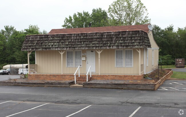
Property Record
796 Pleasant Hill Rd Nw, Lilburn, GA 30047

NEARBY LISTINGS FOR SALE OR LEASE
Property Detail
796 Pleasant Hill Rd Nw
Atlanta-Sandy Springs-Roswell, GA
Pleasant Hill
6-156-003
TRACK 2 PLEASANT HILL RD
Officebuilding
Gwinnett
AE
Georgia
13135C0100F
3
2025
5.20 AC
2025
Stone Mountain
050441
Atlanta
1,224 SF
DEMOGRAPHICS near 796 Pleasant Hill Rd Nw
1 mile
3 mile
5 mile
2024 Total Population
11,589
101,858
265,044
2029 Population
11,916
105,930
276,006
Pop Growth 2024-2029
+ 2.82%
+ 4.00%
+ 4.14%
Average Age
35
35
36
2024 Total Households
3,631
34,502
88,316
HH Growth 2024-2029
+ 2.59%
+ 4.05%
+ 4.19%
Median Household Inc
$50,073
$54,228
$60,547
Avg Household Size
3.00
2.90
2.90
2024 Avg HH Vehicles
2.00
2.00
2.00
Median Home Value
$260,123
$248,141
$270,402
Median Year Built
1992
1991
1990
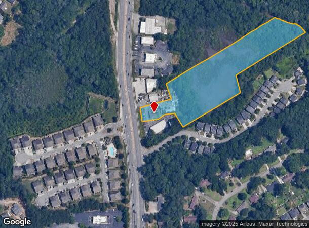
Nearby Places
Map Layers
Map Styles
 Street
 Aerial
Transit
 Traffic
 Biking
Places
Listings with unknown addresses are not visible on the map
- Restaurants
- Banks
- Shops
- Fitness
- Groceries
PUBLIC TRANSPORTATION
AIRPORT
Hartsfield - Jackson Atlanta International
Drive
Walk
Distance
Hartsfield - Jackson Atlanta International
47 min
34.4 mi
SALE & LEASE HISTORY
LISTING DATE
SALE/LEASE

May 23, 2018
For Lease
Nearby Properties
Address
Land Use
TOTAL SIZE
Lot Size
Zoning
Address
Land Use
TOTAL SIZE
Lot Size
Zoning
563,525 SF
47.80 AC
RM13
Address
Land Use
TOTAL SIZE
Lot Size
Zoning
628,779 SF
97.15 AC
M1
Address
Land Use
TOTAL SIZE
Lot Size
Zoning
425,597 SF
49.61 AC
RM13
Address
Land Use
TOTAL SIZE
Lot Size
Zoning
338,670 SF
28.61 AC
RM
Address
Land Use
TOTAL SIZE
Lot Size
Zoning
357,946 SF
30.92 AC
RM
Address
Land Use
TOTAL SIZE
Lot Size
Zoning
444,605 SF
37.43 AC
RM
Address
Land Use
TOTAL SIZE
Lot Size
Zoning
348,681 SF
35.52 AC
RM10
Address
Land Use
TOTAL SIZE
Lot Size
Zoning
440,998 SF
35.04 AC
RM
Address
Land Use
TOTAL SIZE
Lot Size
Zoning
464,756 SF
33.96 AC
RM13
Address
Land Use
TOTAL SIZE
Lot Size
Zoning
584,576 SF
38.60 AC
RM13
Address
Land Use
TOTAL SIZE
Lot Size
Zoning
419,855 SF
29.83 AC
RM13
Address
Land Use
TOTAL SIZE
Lot Size
Zoning
483,912 SF
43.10 AC
OI
Address
Land Use
TOTAL SIZE
Lot Size
Zoning
470,856 SF
34.99 AC
RM13
Address
Land Use
TOTAL SIZE
Lot Size
Zoning
314,338 SF
28.83 AC
RM13
Address
Land Use
TOTAL SIZE
Lot Size
Zoning
361,593 SF
13.35 AC
RM24
Address
Land Use
TOTAL SIZE
Lot Size
Zoning
587,415 SF
4.32 AC
HRR
Address
Land Use
TOTAL SIZE
Lot Size
Zoning
316,443 SF
30.15 AC
RM13
Address
Land Use
TOTAL SIZE
Lot Size
Zoning
265,226 SF
18.05 AC
RM
Address
Land Use
TOTAL SIZE
Lot Size
Zoning
336,554 SF
30.40 AC
RM
Address
Land Use
TOTAL SIZE
Lot Size
Zoning
412,644 SF
23.17 AC
RM
Address
Land Use
TOTAL SIZE
Lot Size
Zoning
313,246 SF
17.15 AC
RM13
Address
Land Use
TOTAL SIZE
Lot Size
Zoning
332,235 SF
17.76 AC
C2
Address
Land Use
TOTAL SIZE
Lot Size
Zoning
455,471 SF
48.23 AC
R75
Address
Land Use
TOTAL SIZE
Lot Size
Zoning
364,994 SF
34.06 AC
RM13
Address
Land Use
TOTAL SIZE
Lot Size
Zoning
331,159 SF
35.49 AC
RM8
Address
Land Use
TOTAL SIZE
Lot Size
Zoning
561,975 SF
41.78 AC
RM13
Address
Land Use
TOTAL SIZE
Lot Size
Zoning
308,378 SF
35.62 AC
C3
Address
Land Use
TOTAL SIZE
Lot Size
Zoning
420,759 SF
33.62 AC
RM13
Address
Land Use
TOTAL SIZE
Lot Size
Zoning
371,383 SF
29.56 AC
RM13
Address
Land Use
TOTAL SIZE
Lot Size
Zoning
287,502 SF
43.15 AC
R1
The World's #1 Commercial Real Estate Marketplace
Connect with us
© 2026 CoStar Group
The information above has been obtained from sources believed reliable. While we do not doubt its accuracy we have not verified it and make no guarantee, warranty or representation about it. It is your responsibility to independently confirm its accuracy and completeness. Any projections, opinions, assumptions, or estimates used are for example only and do not represent the current or future performance of the property. The value of this transaction to you depends on tax and other factors which should be evaluated by your tax, financial, and legal advisors. You and your advisors should conduct a careful, independent investigation of the property to determine to your satisfaction the suitability of the property for your needs.