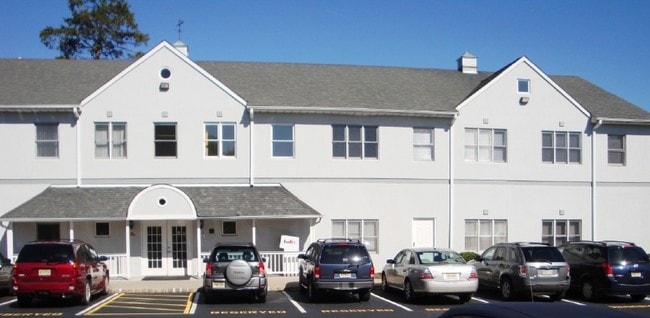
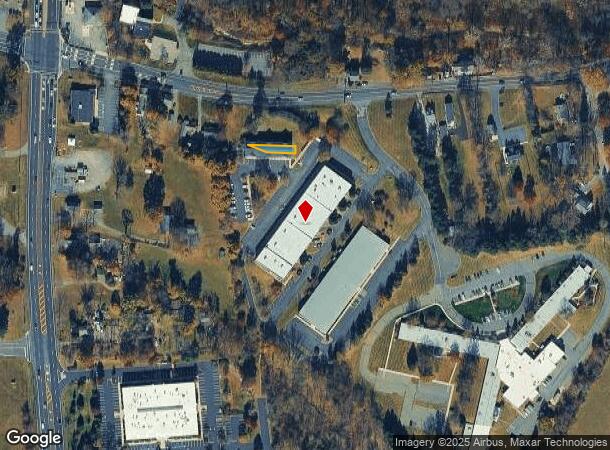
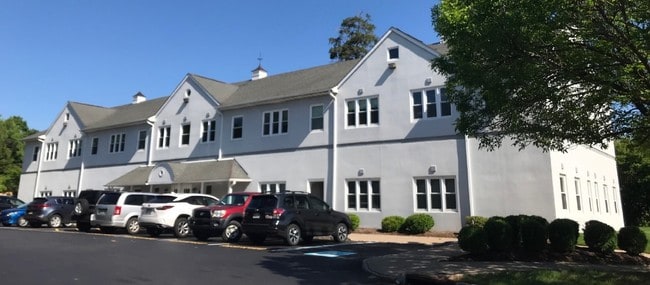
Property Record
8 Bartles Corner Rd, Flemington, NJ 08822
This Property Is For Sale
NEARBY LISTINGS FOR SALE OR LEASE
Property Detail
8 Bartles Corner Rd
21-00016-0000-00014-0000-C0005
Hunterdon
Officebuilding
New Jersey
X
14
34019C0261F
0.05 AC
2024
Hunterdon
2025
Northern New Jersey
011301
Newark, NJ-PA
DEMOGRAPHICS near 8 Bartles Corner Rd
1 Mile
3 Mile
5 Mile
2024 Total Population
2,448
22,541
39,180
2029 Population
2,599
23,120
39,900
Pop Growth 2024-2029
+ 6.17%
+ 2.57%
+ 1.84%
Average Age
44
42
43
2024 Total Households
880
8,517
14,547
HH Growth 2024-2029
+ 6.48%
+ 2.56%
+ 1.87%
Median Household Inc
$167,446
$114,507
$129,677
Avg Household Size
2.70
2.60
2.60
2024 Avg HH Vehicles
2.00
2.00
2.00
Median Home Value
$455,185
$438,198
$472,008
Median Year Built
1992
1982
1982
Nearby Places
- Restaurants
- Banks
- Shops
- Fitness
- Groceries
PUBLIC TRANSPORTATION
COMMUTER RAIL
White House (Raritan Valley Line - NJ Transit Commuter Rail (NJ Transit))
DRIVE
WALK
Distance
White House (Raritan Valley Line - NJ Transit Commuter Rail (NJ Transit))
20 min
7.9 mi
Annandale (Raritan Valley Line - NJ Transit Commuter Rail (NJ Transit))
DRIVE
WALK
Distance
Annandale (Raritan Valley Line - NJ Transit Commuter Rail (NJ Transit))
13 min
8.4 mi
AIRPORT
Trenton Mercer
DRIVE
WALK
Distance
Trenton Mercer
38 min
22.3 mi
Lehigh Valley International
DRIVE
WALK
Distance
Lehigh Valley International
59 min
41.1 mi
Freight Ports
Port of Philadelphia
DRIVE
WALK
Distance
Port of Philadelphia
75 min
44.8 mi
Nearby Properties
Address
Land Use
TOTAL SIZE
Lot Size
Zoning
Address
Land Use
TOTAL SIZE
Lot Size
Zoning
34.80 AC
H
Address
Land Use
TOTAL SIZE
Lot Size
Zoning
68.38 AC
P
Address
Land Use
TOTAL SIZE
Lot Size
Zoning
7.88 AC
CR
Address
Land Use
TOTAL SIZE
Lot Size
Zoning
39.32 AC
P
Address
Land Use
TOTAL SIZE
Lot Size
Zoning
19.85 AC
B-2
Address
Land Use
TOTAL SIZE
Lot Size
Zoning
10,546 SF
12.75 AC
GA
Address
Land Use
TOTAL SIZE
Lot Size
Zoning
12,208 SF
11 AC
GA
Address
Land Use
TOTAL SIZE
Lot Size
Zoning
11.90 AC
CR
Address
Land Use
TOTAL SIZE
Lot Size
Zoning
11.59 AC
B-2
Address
Land Use
TOTAL SIZE
Lot Size
Zoning
23.84 AC
I-2
Address
Land Use
TOTAL SIZE
Lot Size
Zoning
20.89 AC
O/SS
Address
Land Use
TOTAL SIZE
Lot Size
Zoning
26.03 AC
I-2
Address
Land Use
TOTAL SIZE
Lot Size
Zoning
108.22 AC
I-2
Address
Land Use
TOTAL SIZE
Lot Size
Zoning
1,418 SF
19.67 AC
P
Address
Land Use
TOTAL SIZE
Lot Size
Zoning
4.34 AC
PO
Address
Land Use
TOTAL SIZE
Lot Size
Zoning
12.75 AC
B-2
Address
Land Use
TOTAL SIZE
Lot Size
Zoning
11.58 AC
P
Address
Land Use
TOTAL SIZE
Lot Size
Zoning
0.75 AC
H
Address
Land Use
TOTAL SIZE
Lot Size
Zoning
31.46 AC
R-3
Address
Land Use
TOTAL SIZE
Lot Size
Zoning
4.51 AC
R-3
Address
Land Use
TOTAL SIZE
Lot Size
Zoning
16.01 AC
I-2
Address
Land Use
TOTAL SIZE
Lot Size
Zoning
7.99 AC
CR
Address
Land Use
TOTAL SIZE
Lot Size
Zoning
8.07 AC
I-2
Address
Land Use
TOTAL SIZE
Lot Size
Zoning
13.56 AC
CR
Address
Land Use
TOTAL SIZE
Lot Size
Zoning
2,826 SF
6.28 AC
B-2
Address
Land Use
TOTAL SIZE
Lot Size
Zoning
7.75 AC
HR
Address
Land Use
TOTAL SIZE
Lot Size
Zoning
38.30 AC
O-2
Address
Land Use
TOTAL SIZE
Lot Size
Zoning
7.09 AC
I-2
Address
Land Use
TOTAL SIZE
Lot Size
Zoning
15,048 SF
5.61 AC
C-3
Address
Land Use
TOTAL SIZE
Lot Size
Zoning
4.33 AC
B-2
The World's #1 Commercial Real Estate Marketplace
Connect with us
© 2025 CoStar Group
The information above has been obtained from sources believed reliable. While we do not doubt its accuracy we have not verified it and make no guarantee, warranty or representation about it. It is your responsibility to independently confirm its accuracy and completeness. Any projections, opinions, assumptions, or estimates used are for example only and do not represent the current or future performance of the property. The value of this transaction to you depends on tax and other factors which should be evaluated by your tax, financial, and legal advisors. You and your advisors should conduct a careful, independent investigation of the property to determine to your satisfaction the suitability of the property for your needs.