Property Record
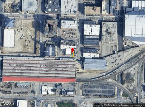
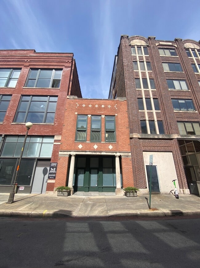
12 W West St, Indianapolis, IN 46202

Current Lease Availabilities
NEARBY LISTINGS FOR SALE OR LEASE
Property Detail
12 W West St
Indianapolis-Carmel-Anderson, IN
Morris Sub
49-11-12-108-002.000-101
MORRIS SUB 21FT 11IN W OF 42FT 8IN E END L6 SQ87
Commercialnec
Marion
X
Indiana
18097C0143G
6
2023
0.04 AC
2024
CBD
356900
Indianapolis
4,662 SF
DEMOGRAPHICS near 12 W West St
1 Mile
3 Mile
5 Mile
2024 Total Population
14,094
119,293
272,300
2029 Population
14,263
121,868
275,198
Pop Growth 2024-2029
+ 1.20%
+ 2.16%
+ 1.06%
Average Age
34
35
36
2024 Total Households
7,973
53,302
114,406
HH Growth 2024-2029
+ 1.28%
+ 2.15%
+ 1.08%
Median Household Inc
$83,648
$54,445
$49,724
Avg Household Size
1.60
2.10
2.20
2024 Avg HH Vehicles
1.00
1.00
1.00
Median Home Value
$351,025
$195,633
$147,305
Median Year Built
1998
1949
1951
Nearby Places
Map Layers
Map Styles
 Street
 Aerial
- Restaurants
- Banks
- Shops
- Fitness
- Groceries
PUBLIC TRANSPORTATION
COMMUTER RAIL
Indianapolis (Cardinal - Amtrak)
DRIVE
WALK
Distance
Indianapolis (Cardinal - Amtrak)
0 min
4 min
0.2 mi
AIRPORT
Indianapolis International
DRIVE
WALK
Distance
Indianapolis International
24 min
13.4 mi
Freight Ports
Port of Toledo
DRIVE
WALK
Distance
Port of Toledo
271 min
226.1 mi
Nearby Properties
Address
Land Use
TOTAL SIZE
Lot Size
Zoning
Address
Land Use
TOTAL SIZE
Lot Size
Zoning
33.61 AC
ZO01
Address
Land Use
TOTAL SIZE
Lot Size
Zoning
1,381,492 SF
15.08 AC
ZO01
Address
Land Use
TOTAL SIZE
Lot Size
Zoning
546,391 SF
4.38 AC
ZO01
Address
Land Use
TOTAL SIZE
Lot Size
Zoning
5.59 AC
ZO01
Address
Land Use
TOTAL SIZE
Lot Size
Zoning
23,200 SF
1.71 AC
Address
Land Use
TOTAL SIZE
Lot Size
Zoning
41.83 AC
ZO01
Address
Land Use
TOTAL SIZE
Lot Size
Zoning
302,187 SF
1.97 AC
ZO01
Address
Land Use
TOTAL SIZE
Lot Size
Zoning
19,176 SF
28.36 AC
ZO01
Address
Land Use
TOTAL SIZE
Lot Size
Zoning
19,536 SF
4.05 AC
ZO01
Address
Land Use
TOTAL SIZE
Lot Size
Zoning
83,966 SF
2.30 AC
ZO01
Address
Land Use
TOTAL SIZE
Lot Size
Zoning
2,273 SF
1.52 AC
ZO01
Address
Land Use
TOTAL SIZE
Lot Size
Zoning
12,392 SF
0.99 AC
ZO01
Address
Land Use
TOTAL SIZE
Lot Size
Zoning
44,485 SF
0.76 AC
ZO01
Address
Land Use
TOTAL SIZE
Lot Size
Zoning
500,908 SF
10.36 AC
ZO01
Address
Land Use
TOTAL SIZE
Lot Size
Zoning
19,896 SF
32.59 AC
ZO01
Address
Land Use
TOTAL SIZE
Lot Size
Zoning
170,000 SF
4.05 AC
ZO01
Address
Land Use
TOTAL SIZE
Lot Size
Zoning
20,422 SF
0.42 AC
ZO01
Address
Land Use
TOTAL SIZE
Lot Size
Zoning
12.63 AC
ZO01
Address
Land Use
TOTAL SIZE
Lot Size
Zoning
384,520 SF
1.93 AC
ZO01
Address
Land Use
TOTAL SIZE
Lot Size
Zoning
123,373 SF
2.14 AC
ZO01
Address
Land Use
TOTAL SIZE
Lot Size
Zoning
5,200 SF
2.43 AC
ZO01
Address
Land Use
TOTAL SIZE
Lot Size
Zoning
6,000 SF
0.47 AC
ZO01
Address
Land Use
TOTAL SIZE
Lot Size
Zoning
21,809 SF
1.57 AC
ZO01
Address
Land Use
TOTAL SIZE
Lot Size
Zoning
36,000 SF
0.94 AC
ZO01
Address
Land Use
TOTAL SIZE
Lot Size
Zoning
40,205 SF
1.58 AC
Address
Land Use
TOTAL SIZE
Lot Size
Zoning
11,775 SF
0.44 AC
ZO01
Address
Land Use
TOTAL SIZE
Lot Size
Zoning
309,006 SF
1.48 AC
ZO01
Address
Land Use
TOTAL SIZE
Lot Size
Zoning
2,674 SF
3.05 AC
ZO01
Address
Land Use
TOTAL SIZE
Lot Size
Zoning
217,895 SF
3.43 AC
ZO01
Address
Land Use
TOTAL SIZE
Lot Size
Zoning
245,608 SF
0.90 AC
The World's #1 Commercial Real Estate Marketplace
Connect with us
© 2025 CoStar Group
The information above has been obtained from sources believed reliable. While we do not doubt its accuracy we have not verified it and make no guarantee, warranty or representation about it. It is your responsibility to independently confirm its accuracy and completeness. Any projections, opinions, assumptions, or estimates used are for example only and do not represent the current or future performance of the property. The value of this transaction to you depends on tax and other factors which should be evaluated by your tax, financial, and legal advisors. You and your advisors should conduct a careful, independent investigation of the property to determine to your satisfaction the suitability of the property for your needs.