Property Record
750 E Covey Ln, Phoenix, AZ 85024

NEARBY LISTINGS FOR SALE OR LEASE
Property Detail
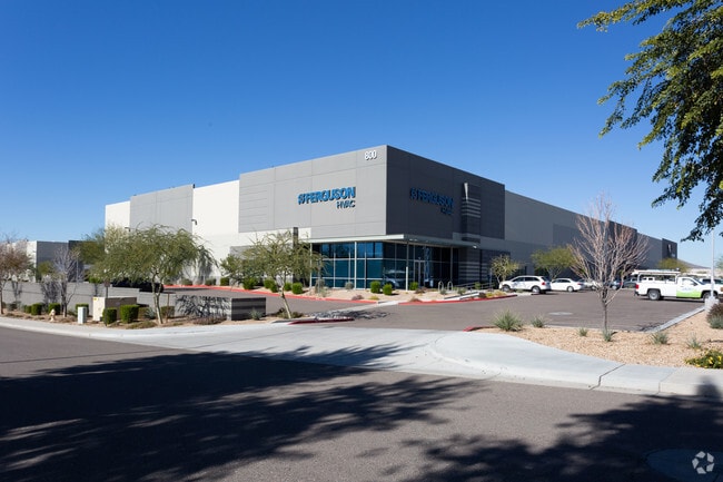
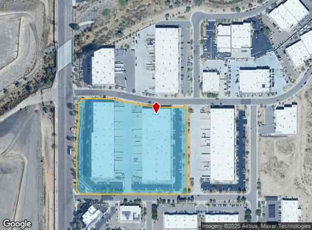
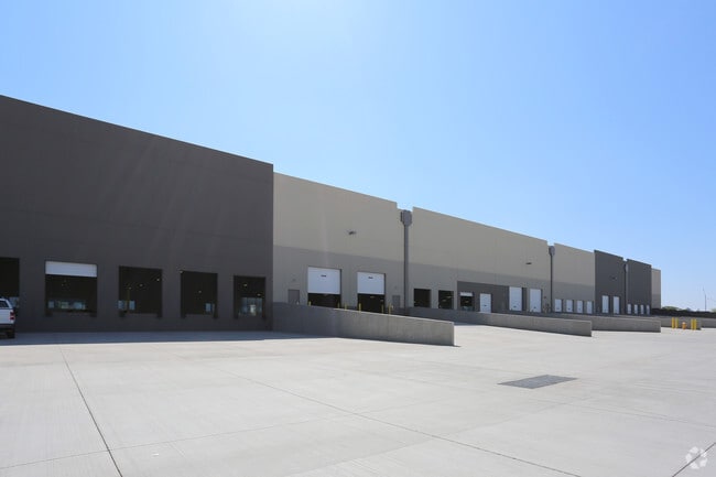
750 E Covey Ln
Phoenix-Mesa-Chandler, AZ
Park Ladera At Spectrum Ridge
213-05-980
PARK LADERA AT SPECTRUM RIDGE MCR 1202-47
Warehouse
Maricopa
X
Arizona
04013C1290M
1
2025
9.32 AC
2025
Deer Vly/Pinnacle Pk
614900
Phoenix
150,553 SF
DEMOGRAPHICS near 750 E Covey Ln
1 Mile
3 Mile
5 Mile
2024 Total Population
5,141
93,120
238,692
2029 Population
5,520
100,609
258,169
Pop Growth 2024-2029
+ 7.37%
+ 8.04%
+ 8.16%
Average Age
37
38
38
2024 Total Households
2,220
39,203
95,904
HH Growth 2024-2029
+ 7.43%
+ 8.14%
+ 8.28%
Median Household Inc
$74,047
$67,646
$75,783
Avg Household Size
2.30
2.30
2.40
2024 Avg HH Vehicles
2.00
2.00
2.00
Median Home Value
$337,790
$313,379
$357,673
Median Year Built
1993
1989
1989
Nearby Places
Map Layers
Map Styles
 Street
 Aerial
- Restaurants
- Banks
- Shops
- Fitness
- Groceries
PUBLIC TRANSPORTATION
AIRPORT
Phoenix Sky Harbor International
DRIVE
WALK
Distance
Phoenix Sky Harbor International
34 min
24.2 mi
Phoenix-Mesa Gateway
DRIVE
WALK
Distance
Phoenix-Mesa Gateway
64 min
48.5 mi
SALE & LEASE HISTORY
LISTING DATE
SALE/LEASE

Aug 10, 2017
For Lease
Nearby Properties
Address
Land Use
TOTAL SIZE
Lot Size
Zoning
Address
Land Use
TOTAL SIZE
Lot Size
Zoning
132,348 SF
9.16 AC
I-P
Address
Land Use
TOTAL SIZE
Lot Size
Zoning
Address
Land Use
TOTAL SIZE
Lot Size
Zoning
267,397 SF
108.70 AC
R-43AG
Address
Land Use
TOTAL SIZE
Lot Size
Zoning
429,168 SF
9.52 AC
R-8
Address
Land Use
TOTAL SIZE
Lot Size
Zoning
289,901 SF
12.30 AC
A-1
Address
Land Use
TOTAL SIZE
Lot Size
Zoning
471,671 SF
18.04 AC
I-1
Address
Land Use
TOTAL SIZE
Lot Size
Zoning
389,967 SF
245.48 AC
I-1
Address
Land Use
TOTAL SIZE
Lot Size
Zoning
8,469 SF
215.03 AC
Address
Land Use
TOTAL SIZE
Lot Size
Zoning
264,909 SF
219.16 AC
I-1
Address
Land Use
TOTAL SIZE
Lot Size
Zoning
968,899 SF
76.37 AC
I-1
Address
Land Use
TOTAL SIZE
Lot Size
Zoning
338,640 SF
10.39 AC
R-4A
Address
Land Use
TOTAL SIZE
Lot Size
Zoning
336,529 SF
11.23 AC
R4A
Address
Land Use
TOTAL SIZE
Lot Size
Zoning
28.71 AC
Address
Land Use
TOTAL SIZE
Lot Size
Zoning
312,070 SF
20.04 AC
A1
Address
Land Use
TOTAL SIZE
Lot Size
Zoning
242,144 SF
29.78 AC
RE-43
Address
Land Use
TOTAL SIZE
Lot Size
Zoning
291,059 SF
16.54 AC
I-1
Address
Land Use
TOTAL SIZE
Lot Size
Zoning
240.86 AC
IND.PK.
Address
Land Use
TOTAL SIZE
Lot Size
Zoning
355,606 SF
11.35 AC
C-C
Address
Land Use
TOTAL SIZE
Lot Size
Zoning
45,487 SF
117.90 AC
S1
Address
Land Use
TOTAL SIZE
Lot Size
Zoning
255,482 SF
15.30 AC
M-H
Address
Land Use
TOTAL SIZE
Lot Size
Zoning
189,524 SF
13.80 AC
I-P
Address
Land Use
TOTAL SIZE
Lot Size
Zoning
240,311 SF
14.42 AC
R-43AG
Address
Land Use
TOTAL SIZE
Lot Size
Zoning
196,485 SF
8.98 AC
Address
Land Use
TOTAL SIZE
Lot Size
Zoning
232,395 SF
17.14 AC
CPGCP
Address
Land Use
TOTAL SIZE
Lot Size
Zoning
217,379 SF
16.13 AC
I-1
Address
Land Use
TOTAL SIZE
Lot Size
Zoning
63,192 SF
94.91 AC
RE43
Address
Land Use
TOTAL SIZE
Lot Size
Zoning
301,696 SF
21.14 AC
I-1
Address
Land Use
TOTAL SIZE
Lot Size
Zoning
316,766 SF
13.32 AC
M-H
Address
Land Use
TOTAL SIZE
Lot Size
Zoning
358,670 SF
18.14 AC
M-H
Address
Land Use
TOTAL SIZE
Lot Size
Zoning
135,370 SF
7.18 AC
I-1
The World's #1 Commercial Real Estate Marketplace
Connect with us
© 2026 CoStar Group
The information above has been obtained from sources believed reliable. While we do not doubt its accuracy we have not verified it and make no guarantee, warranty or representation about it. It is your responsibility to independently confirm its accuracy and completeness. Any projections, opinions, assumptions, or estimates used are for example only and do not represent the current or future performance of the property. The value of this transaction to you depends on tax and other factors which should be evaluated by your tax, financial, and legal advisors. You and your advisors should conduct a careful, independent investigation of the property to determine to your satisfaction the suitability of the property for your needs.