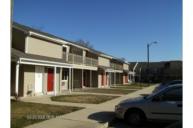
Property Record
800 N Main St, Williamstown, NJ 08094
NEARBY LISTINGS FOR SALE OR LEASE
-
-
View all Williamstown listings for sale on LoopNet.com
Property Detail
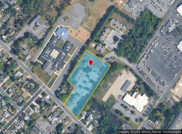
800 N Main St
11-01701-0000-00011-02
Gloucester
Apartment
New Jersey
X
11.2
34015C0209E
3.53 AC
2024
Lower Gloucester County
2025
Philadelphia
501603
Philadelphia-Camden-Wilmington, PA-NJ-DE-MD
DEMOGRAPHICS near 800 N Main St
1 Mile
3 Mile
5 Mile
2024 Total Population
8,598
50,989
107,274
2029 Population
8,910
52,264
109,691
Pop Growth 2024-2029
+ 3.63%
+ 2.50%
+ 2.25%
Average Age
43
40
40
2024 Total Households
3,496
18,506
38,373
HH Growth 2024-2029
+ 3.52%
+ 2.52%
+ 2.35%
Median Household Inc
$77,702
$92,401
$98,502
Avg Household Size
2.40
2.70
2.70
2024 Avg HH Vehicles
2.00
2.00
2.00
Median Home Value
$214,483
$245,109
$258,502
Median Year Built
1980
1986
1985
Nearby Places
Map Layers
Map Styles
 Street
 Aerial
- Restaurants
- Banks
- Shops
- Fitness
- Groceries
PUBLIC TRANSPORTATION
COMMUTER RAIL
Atco (Atlantic City Line - NJ Transit Commuter Rail (NJ Transit))
DRIVE
WALK
Distance
Atco (Atlantic City Line - NJ Transit Commuter Rail (NJ Transit))
16 min
9.2 mi
AIRPORT
Philadelphia International
DRIVE
WALK
Distance
Philadelphia International
44 min
27.0 mi
Atlantic City International
DRIVE
WALK
Distance
Atlantic City International
64 min
35.0 mi
Freight Ports
Broadway Terminal - Pier 5
DRIVE
WALK
Distance
Broadway Terminal - Pier 5
28 min
18.4 mi
Nearby Properties
Address
Land Use
TOTAL SIZE
Lot Size
Zoning
Address
Land Use
TOTAL SIZE
Lot Size
Zoning
64.09 AC
HC
Address
Land Use
TOTAL SIZE
Lot Size
Zoning
38.92 AC
HC
Address
Land Use
TOTAL SIZE
Lot Size
Zoning
46.45 AC
RGMR
Address
Land Use
TOTAL SIZE
Lot Size
Zoning
74.69 AC
RGMR
Address
Land Use
TOTAL SIZE
Lot Size
Zoning
26.77 AC
HC
Address
Land Use
TOTAL SIZE
Lot Size
Zoning
14.07 AC
Address
Land Use
TOTAL SIZE
Lot Size
Zoning
18.02 AC
HC
Address
Land Use
TOTAL SIZE
Lot Size
Zoning
20.63 AC
C
Address
Land Use
TOTAL SIZE
Lot Size
Zoning
15.36 AC
Address
Land Use
TOTAL SIZE
Lot Size
Zoning
1,563 SF
32.90 AC
RL
Address
Land Use
TOTAL SIZE
Lot Size
Zoning
19.53 AC
R2
Address
Land Use
TOTAL SIZE
Lot Size
Zoning
13.69 AC
CC
Address
Land Use
TOTAL SIZE
Lot Size
Zoning
15.45 AC
HC
Address
Land Use
TOTAL SIZE
Lot Size
Zoning
19.86 AC
HC
Address
Land Use
TOTAL SIZE
Lot Size
Zoning
35.07 AC
Address
Land Use
TOTAL SIZE
Lot Size
Zoning
1 SF
19.71 AC
CC
Address
Land Use
TOTAL SIZE
Lot Size
Zoning
9.76 AC
R2
Address
Land Use
TOTAL SIZE
Lot Size
Zoning
29.50 AC
FD10
Address
Land Use
TOTAL SIZE
Lot Size
Zoning
7.69 AC
RG30
Address
Land Use
TOTAL SIZE
Lot Size
Zoning
5.60 AC
Address
Land Use
TOTAL SIZE
Lot Size
Zoning
3.44 AC
RM
Address
Land Use
TOTAL SIZE
Lot Size
Zoning
13.03 AC
RL
Address
Land Use
TOTAL SIZE
Lot Size
Zoning
10.98 AC
RGPR
Address
Land Use
TOTAL SIZE
Lot Size
Zoning
11.46 AC
RGPR
Address
Land Use
TOTAL SIZE
Lot Size
Zoning
17.52 AC
P
Address
Land Use
TOTAL SIZE
Lot Size
Zoning
12.13 AC
P
Address
Land Use
TOTAL SIZE
Lot Size
Zoning
2.80 AC
RG30
Address
Land Use
TOTAL SIZE
Lot Size
Zoning
6.51 AC
C
Address
Land Use
TOTAL SIZE
Lot Size
Zoning
Address
Land Use
TOTAL SIZE
Lot Size
Zoning
12.20 AC
CC
The World's #1 Commercial Real Estate Marketplace
Connect with us
© 2025 CoStar Group
The information above has been obtained from sources believed reliable. While we do not doubt its accuracy we have not verified it and make no guarantee, warranty or representation about it. It is your responsibility to independently confirm its accuracy and completeness. Any projections, opinions, assumptions, or estimates used are for example only and do not represent the current or future performance of the property. The value of this transaction to you depends on tax and other factors which should be evaluated by your tax, financial, and legal advisors. You and your advisors should conduct a careful, independent investigation of the property to determine to your satisfaction the suitability of the property for your needs.