Property Record
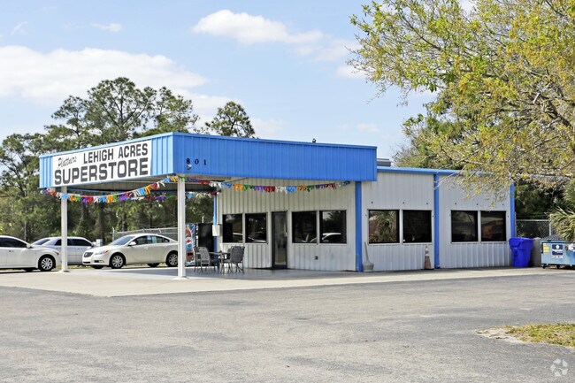
801 Abrams Blvd, Lehigh Acres, FL 33971


Property Detail
801 Abrams Blvd
30-44-26-02-00000.A010
LEHIGH ACRES UNIT 2 PB 26 PG 52 TRACT A
Vehiclerentalsvehiclesales
Lee
C-2
Florida
B and X Area of moderate flood hazard, usually the area between the limits of the 100-year and 500-year floods.
a
2025
4.31 AC
2025
Lehigh
040124
Southwest Florida
2,280 SF
Cape Coral-Fort Myers, FL
NEARBY LISTINGS FOR SALE OR LEASE
DEMOGRAPHICS near 801 Abrams Blvd
1 mile
3 mile
5 mile
2025 Total Population
6,783
44,219
104,670
2030 Population
7,336
48,248
115,511
Pop Growth 2025-2030
+ 8.15%
+ 9.11%
+ 10.36%
Average Age
34
38
40
2025 Total Households
2,024
14,656
37,033
HH Growth 2025-2030
+ 7.51%
+ 8.62%
+ 10.15%
Median Household Inc
$73,492
$75,574
$80,360
Avg Household Size
3.20
2.90
2.70
2025 Avg HH Vehicles
2.00
2.00
2.00
Median Home Value
$318,006
$372,755
$382,749
Median Year Built
2004
2005
2006
Nearby Places
Map Layers
Map Styles
 Street
 Aerial
Layers
 Traffic
 Biking
Places
Listings with unknown addresses are not visible on the map
- Restaurants
- Banks
- Shops
- Fitness
- Groceries
PUBLIC TRANSPORTATION
AIRPORT
Southwest Florida International
Drive
Walk
Distance
Southwest Florida International
15 min
8.2 mi
Punta Gorda
Drive
Walk
Distance
Punta Gorda
36 min
29.2 mi
Freight Ports
Port Manatee
Drive
Walk
Distance
Port Manatee
116 min
100.9 mi
Nearby Properties
Address
Land Use
TOTAL SIZE
Lot Size
Zoning
Address
Land Use
TOTAL SIZE
Lot Size
Zoning
519,706 SF
95.18 AC
RS-1
Address
Land Use
TOTAL SIZE
Lot Size
Zoning
111.70 AC
C1
Address
Land Use
TOTAL SIZE
Lot Size
Zoning
17.50 AC
C1
Address
Land Use
TOTAL SIZE
Lot Size
Zoning
24.69 AC
C-1
Address
Land Use
TOTAL SIZE
Lot Size
Zoning
320,566 SF
500.70 AC
AG-2
Address
Land Use
TOTAL SIZE
Lot Size
Zoning
333,614 SF
294.30 AC
AG-2
Address
Land Use
TOTAL SIZE
Lot Size
Zoning
154,653 SF
11.77 AC
SDA
Address
Land Use
TOTAL SIZE
Lot Size
Zoning
173,791 SF
119.05 AC
AG-2
Address
Land Use
TOTAL SIZE
Lot Size
Zoning
135,503 SF
15.29 AC
AG-2
Address
Land Use
TOTAL SIZE
Lot Size
Zoning
68.11 AC
PUD
Address
Land Use
TOTAL SIZE
Lot Size
Zoning
29.75 AC
CI
Address
Land Use
TOTAL SIZE
Lot Size
Zoning
85,812 SF
15.76 AC
PUD
Address
Land Use
TOTAL SIZE
Lot Size
Zoning
75,477 SF
12.24 AC
SDA
Address
Land Use
TOTAL SIZE
Lot Size
Zoning
95,220 SF
3.23 AC
SDA
Address
Land Use
TOTAL SIZE
Lot Size
Zoning
2.10 AC
C1
Address
Land Use
TOTAL SIZE
Lot Size
Zoning
142,693 SF
5.97 AC
C-2
Address
Land Use
TOTAL SIZE
Lot Size
Zoning
43,676 SF
10.48 AC
CF-2
Address
Land Use
TOTAL SIZE
Lot Size
Zoning
35,579 SF
8.06 AC
SDA
Address
Land Use
TOTAL SIZE
Lot Size
Zoning
108,797 SF
7.39 AC
IL
Address
Land Use
TOTAL SIZE
Lot Size
Zoning
35,974 SF
3.16 AC
IL
Address
Land Use
TOTAL SIZE
Lot Size
Zoning
70,622 SF
2.17 AC
CPD
Address
Land Use
TOTAL SIZE
Lot Size
Zoning
76,999 SF
34.31 AC
C-2
Address
Land Use
TOTAL SIZE
Lot Size
Zoning
11.76 AC
SDA
Address
Land Use
TOTAL SIZE
Lot Size
Zoning
6,710 SF
1.24 AC
SDA
Address
Land Use
TOTAL SIZE
Lot Size
Zoning
35,087 SF
3.34 AC
MU
Address
Land Use
TOTAL SIZE
Lot Size
Zoning
13,953 SF
2.43 AC
MU
Address
Land Use
TOTAL SIZE
Lot Size
Zoning
22,254 SF
2.35 AC
IL
Address
Land Use
TOTAL SIZE
Lot Size
Zoning
19,085 SF
7.30 AC
PUD
Address
Land Use
TOTAL SIZE
Lot Size
Zoning
27,521 SF
4.01 AC
CPD
Address
Land Use
TOTAL SIZE
Lot Size
Zoning
20,220 SF
9.67 AC
CF
The World's #1 Commercial Real Estate Marketplace
Connect with us
© 2026 CoStar Group
The information above has been obtained from sources believed reliable. While we do not doubt its accuracy we have not verified it and make no guarantee, warranty or representation about it. It is your responsibility to independently confirm its accuracy and completeness. Any projections, opinions, assumptions, or estimates used are for example only and do not represent the current or future performance of the property. The value of this transaction to you depends on tax and other factors which should be evaluated by your tax, financial, and legal advisors. You and your advisors should conduct a careful, independent investigation of the property to determine to your satisfaction the suitability of the property for your needs.