Property Record
801 E Roth Rd, French Camp, CA 95231


Save to a Folder
{{folder.Name}}
{{folder.ListingIds.length}} Properties
{{folder.ListingIds.length}} Property
Create a New Folder
Property Detail
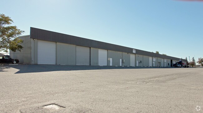
801 E Roth Rd
193-320-18
88-FM 10 & 11 LOT MERGER 87098421
Lightindustrial
SAN JOAQUIN
IL
California
C and X Area of minimal flood hazard, usually depicted on FIRMs as above the 500-year flood level.
a
2025
9.74 AC
2025
SE Stockton
003803
Stockton/Modesto
24,000 SF
Stockton-Lodi, CA
NEARBY LISTINGS FOR SALE OR LEASE
DEMOGRAPHICS near 801 E Roth Rd
1 mile
3 mile
5 mile
2025 Total Population
979
26,693
127,880
2030 Population
1,001
27,759
133,865
Pop Growth 2025-2030
+ 2.25%
+ 3.99%
+ 4.68%
Average Age
39
41
38
2025 Total Households
310
8,211
36,520
HH Growth 2025-2030
+ 2.26%
+ 4.18%
+ 4.91%
Median Household Inc
$92,924
$108,639
$91,691
Avg Household Size
3.10
3.10
3.30
2025 Avg HH Vehicles
3.00
3.00
2.00
Median Home Value
$672,680
$673,924
$567,435
Median Year Built
1973
1999
1994
Nearby Places
Map Layers
Map Styles
 Street
 Aerial
Layers
 Traffic
 Biking
Places
Listings with unknown addresses are not visible on the map
- Restaurants
- Banks
- Shops
- Fitness
- Groceries
PUBLIC TRANSPORTATION
COMMUTER RAIL
Drive
Walk
Distance
11 min
5.7 mi
Drive
Walk
Distance
12 min
7.9 mi
AIRPORT
Stockton Metro
Drive
Walk
Distance
Stockton Metro
8 min
3.7 mi
Freight Ports
Port of Stockton
Drive
Walk
Distance
Port of Stockton
14 min
9.8 mi
SALE & LEASE HISTORY
LISTING DATE
SALE/LEASE

Sep 24, 2016
For Lease
Nearby Properties
Address
Land Use
TOTAL SIZE
Lot Size
Zoning
Address
Land Use
TOTAL SIZE
Lot Size
Zoning
730,300 SF
41.44 AC
Address
Land Use
TOTAL SIZE
Lot Size
Zoning
240,210 SF
66.15 AC
Address
Land Use
TOTAL SIZE
Lot Size
Zoning
622,959 SF
31.75 AC
IW
Address
Land Use
TOTAL SIZE
Lot Size
Zoning
600 SF
19.12 AC
Address
Land Use
TOTAL SIZE
Lot Size
Zoning
746,790 SF
39.23 AC
M2
Address
Land Use
TOTAL SIZE
Lot Size
Zoning
830,175 SF
46.57 AC
IG
Address
Land Use
TOTAL SIZE
Lot Size
Zoning
824,735 SF
52.87 AC
Address
Land Use
TOTAL SIZE
Lot Size
Zoning
Address
Land Use
TOTAL SIZE
Lot Size
Zoning
745,640 SF
41.63 AC
Address
Land Use
TOTAL SIZE
Lot Size
Zoning
565,580 SF
56.99 AC
Address
Land Use
TOTAL SIZE
Lot Size
Zoning
16.02 AC
Address
Land Use
TOTAL SIZE
Lot Size
Zoning
419,608 SF
23.01 AC
IG
Address
Land Use
TOTAL SIZE
Lot Size
Zoning
434,900 SF
17.05 AC
Address
Land Use
TOTAL SIZE
Lot Size
Zoning
343,732 SF
13.90 AC
Address
Land Use
TOTAL SIZE
Lot Size
Zoning
436,800 SF
21.71 AC
Address
Land Use
TOTAL SIZE
Lot Size
Zoning
19,912 SF
6.49 AC
C1
Address
Land Use
TOTAL SIZE
Lot Size
Zoning
452,000 SF
20.42 AC
Address
Land Use
TOTAL SIZE
Lot Size
Zoning
443,640 SF
24.30 AC
Address
Land Use
TOTAL SIZE
Lot Size
Zoning
178,761 SF
11.43 AC
Address
Land Use
TOTAL SIZE
Lot Size
Zoning
404,657 SF
24.89 AC
AG40
Address
Land Use
TOTAL SIZE
Lot Size
Zoning
164,000 SF
7.62 AC
Address
Land Use
TOTAL SIZE
Lot Size
Zoning
500,000 SF
28.38 AC
Address
Land Use
TOTAL SIZE
Lot Size
Zoning
510,495 SF
23.54 AC
Address
Land Use
TOTAL SIZE
Lot Size
Zoning
247,485 SF
63.57 AC
Address
Land Use
TOTAL SIZE
Lot Size
Zoning
10.83 AC
Address
Land Use
TOTAL SIZE
Lot Size
Zoning
11.32 AC
Address
Land Use
TOTAL SIZE
Lot Size
Zoning
110,000 SF
15.10 AC
Address
Land Use
TOTAL SIZE
Lot Size
Zoning
4,800 SF
32.64 AC
Address
Land Use
TOTAL SIZE
Lot Size
Zoning
7.72 AC
Address
Land Use
TOTAL SIZE
Lot Size
Zoning
The World's #1 Commercial Real Estate Marketplace
Connect with us
© 2026 CoStar Group
The information above has been obtained from sources believed reliable. While we do not doubt its accuracy we have not verified it and make no guarantee, warranty or representation about it. It is your responsibility to independently confirm its accuracy and completeness. Any projections, opinions, assumptions, or estimates used are for example only and do not represent the current or future performance of the property. The value of this transaction to you depends on tax and other factors which should be evaluated by your tax, financial, and legal advisors. You and your advisors should conduct a careful, independent investigation of the property to determine to your satisfaction the suitability of the property for your needs.