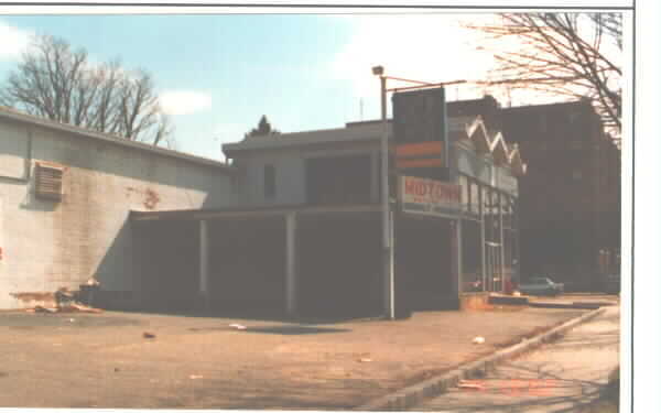
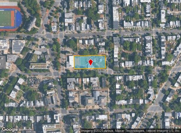
Property Record
801 Taylor St Nw, Washington, DC 20011
NEARBY LISTINGS FOR SALE OR LEASE
Property Detail
801 Taylor St Nw
Washington-Arlington-Alexandria, DC-VA-MD-WV
Petworth
3025-0812
SQUARE 3025 LOT 0812 NBHD: PETWORTH
Recreationalentertainmentgeneral
District of Columbia
X
District of Columbia
24033C0110E
812
0
0.96 AC
2025
Uptown
002400
Washington, DC
1,200 SF
DEMOGRAPHICS near 801 Taylor St Nw
1 Mile
3 Mile
5 Mile
2024 Total Population
51,077
351,320
765,982
2029 Population
45,597
320,863
718,540
Pop Growth 2024-2029
(10.73%)
(8.67%)
(6.19%)
Average Age
37
38
38
2024 Total Households
20,442
167,028
347,945
HH Growth 2024-2029
(11.61%)
(9.52%)
(6.94%)
Median Household Inc
$104,212
$103,259
$105,447
Avg Household Size
2.40
2.00
2.10
2024 Avg HH Vehicles
1.00
1.00
1.00
Median Home Value
$744,221
$737,241
$739,938
Median Year Built
1947
1954
1960
Nearby Places
Map Layers
Map Styles
 Street
 Aerial
- Restaurants
- Banks
- Shops
- Fitness
- Groceries
PUBLIC TRANSPORTATION
TRANSIT/SUBWAY
Georgia Ave-Petworth (Green Line - Washington Metropolitan Area Transit Authority Metrorail (Metrorail), Yellow Line - Washington Metropolitan Area Transit Authority Metrorail (Metrorail))
DRIVE
WALK
Distance
Georgia Ave-Petworth (Green Line - Washington Metropolitan Area Transit Authority Metrorail (Metrorail), Yellow Line - Washington Metropolitan Area Transit Authority Metrorail (Metrorail))
1 min
7 min
0.4 mi
COMMUTER RAIL
DRIVE
WALK
Distance
8 min
3.7 mi
Silver Spring (Brunswick Line - Maryland Area Regional Commuter Trains (The MARC))
DRIVE
WALK
Distance
Silver Spring (Brunswick Line - Maryland Area Regional Commuter Trains (The MARC))
11 min
3.8 mi
AIRPORT
Ronald Reagan Washington Ntl
DRIVE
WALK
Distance
Ronald Reagan Washington Ntl
19 min
8.0 mi
Washington Dulles International
DRIVE
WALK
Distance
Washington Dulles International
51 min
29.4 mi
Baltimore/Washington International Thurgood Marshall
DRIVE
WALK
Distance
Baltimore/Washington International Thurgood Marshall
48 min
32.6 mi
Freight Ports
Port of Baltimore
DRIVE
WALK
Distance
Port of Baltimore
51 min
35.2 mi
Nearby Properties
Address
Land Use
TOTAL SIZE
Lot Size
Zoning
Address
Land Use
TOTAL SIZE
Lot Size
Zoning
2,300,000 SF
1.60 AC
D-5-R
Address
Land Use
TOTAL SIZE
Lot Size
Zoning
1,583,364 SF
276.66 AC
UNZONED
Address
Land Use
TOTAL SIZE
Lot Size
Zoning
1,100,000 SF
2.13 AC
D-6
Address
Land Use
TOTAL SIZE
Lot Size
Zoning
1,310,661 SF
3.38 AC
D-6
Address
Land Use
TOTAL SIZE
Lot Size
Zoning
1,738,573 SF
2.11 AC
D-7
Address
Land Use
TOTAL SIZE
Lot Size
Zoning
1.57 AC
D-5
Address
Land Use
TOTAL SIZE
Lot Size
Zoning
2,247,684 SF
6.39 AC
D-4-R
Address
Land Use
TOTAL SIZE
Lot Size
Zoning
553,914 SF
55.91 AC
R-1B
Address
Land Use
TOTAL SIZE
Lot Size
Zoning
758,000 SF
2.22 AC
D-4-R;MU-7
Address
Land Use
TOTAL SIZE
Lot Size
Zoning
1,185,122 SF
2.43 AC
D-6
Address
Land Use
TOTAL SIZE
Lot Size
Zoning
1,562,988 SF
15.33 AC
MU-10 (IZ+
Address
Land Use
TOTAL SIZE
Lot Size
Zoning
479,505 SF
5 AC
D-6-R
Address
Land Use
TOTAL SIZE
Lot Size
Zoning
1,214,044 SF
1.48 AC
D-6
Address
Land Use
TOTAL SIZE
Lot Size
Zoning
469,183 SF
1.20 AC
D-5
Address
Land Use
TOTAL SIZE
Lot Size
Zoning
1,642,951 SF
95.12 AC
RF-1
Address
Land Use
TOTAL SIZE
Lot Size
Zoning
4.87 AC
D-6
Address
Land Use
TOTAL SIZE
Lot Size
Zoning
512,068 SF
1.36 AC
D-5-R
Address
Land Use
TOTAL SIZE
Lot Size
Zoning
900,000 SF
12.60 AC
RA-4
Address
Land Use
TOTAL SIZE
Lot Size
Zoning
95.32 AC
RA-1
Address
Land Use
TOTAL SIZE
Lot Size
Zoning
314,995 SF
5.83 AC
D-5
Address
Land Use
TOTAL SIZE
Lot Size
Zoning
247,900 SF
170.58 AC
RA-2;UNZON
Address
Land Use
TOTAL SIZE
Lot Size
Zoning
1,018,056 SF
1.14 AC
D-6
Address
Land Use
TOTAL SIZE
Lot Size
Zoning
526,768 SF
1.03 AC
D-5-R
Address
Land Use
TOTAL SIZE
Lot Size
Zoning
814,320 SF
0.99 AC
D-7
Address
Land Use
TOTAL SIZE
Lot Size
Zoning
379,921 SF
1.03 AC
D-5-R
Address
Land Use
TOTAL SIZE
Lot Size
Zoning
431,570 SF
0.78 AC
D-6
Address
Land Use
TOTAL SIZE
Lot Size
Zoning
430,428 SF
0.76 AC
D-6
Address
Land Use
TOTAL SIZE
Lot Size
Zoning
1,835,827 SF
34.66 AC
UNZONED
Address
Land Use
TOTAL SIZE
Lot Size
Zoning
550,211 SF
1.42 AC
D-6
Address
Land Use
TOTAL SIZE
Lot Size
Zoning
511,506 SF
1.18 AC
D-7
The World's #1 Commercial Real Estate Marketplace
Connect with us
© 2025 CoStar Group
The information above has been obtained from sources believed reliable. While we do not doubt its accuracy we have not verified it and make no guarantee, warranty or representation about it. It is your responsibility to independently confirm its accuracy and completeness. Any projections, opinions, assumptions, or estimates used are for example only and do not represent the current or future performance of the property. The value of this transaction to you depends on tax and other factors which should be evaluated by your tax, financial, and legal advisors. You and your advisors should conduct a careful, independent investigation of the property to determine to your satisfaction the suitability of the property for your needs.